Detailed Observation
| Date | 2021-11-26 |
| Location | Haines |
| Observer | Jeff Moskowitz |
| Avalanche | N |
General Observations
Lutak Zone: South winds are drifting new surface storm snow from yesterday into soft wind slabs that are shooting cracks. Steep roll-overs and exposed open terrain above 30 degrees are suspect. These wind slabs could range from a few inches thick to several feet deep in spots prone to wind drifting, including terrain traps. Look for signs of wind loading and avoid these areas.
Uploaded Images


Weather Observations
| New Snow Amount | 65cm |
| Foot Penetration | 80cm |
| Ski Penetration | 25cm |
| Wind Speed | Moderate |
| Wind Direction | SE |
| Sky Cover | Overcast |
| Snowfall Rate | Light |
| Temperature | 19F |
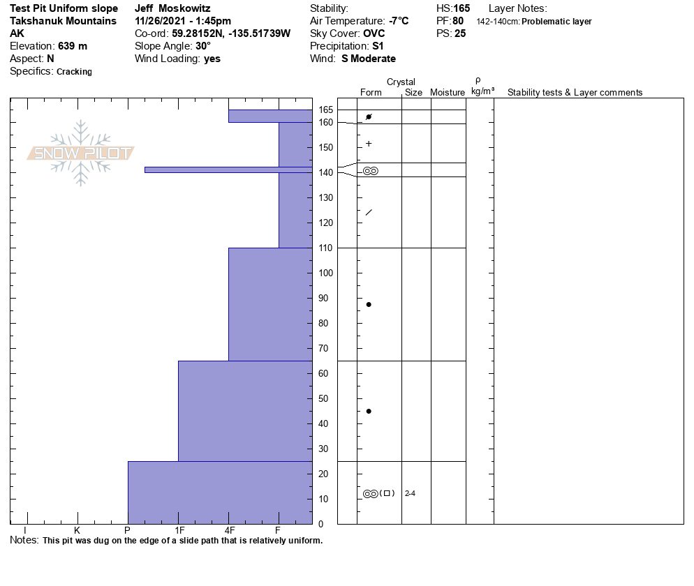
Snowpack Observations
From limited observations and probing the snow, a high degree of spatial variability should be accounted for in our current snowpack. Use wide margins to mitigate the risks. The snowpack might be very different with any change of aspect, elevation, slope, or terrain features.
- At 1,200' the height of snow was 115cm, with 70cm of new snow and a punchy crust down 70-85cm that was hallow underneath.
- At 2,100' the height of snow was 165cm, with 5cm of surface windslab, over new snow and a brittle melt freeze crust between more storm snow.
Areas of rime crust at the surface and deeper pockets of wind drift above 1,500', better snow below 1,500' and dense warmer snow that refroze below 1,000'.