Chugach National Forest
Above 2,500ftHigh
1,500 to 2,500ftHigh
Below 1,500ftConsiderable
Degrees of Avalanche Danger
Avalanche Problems
Problem 1

Likelihood:
- Almost Certain
- Very Likely
- Likely
- Possible
- Unlikely
Size:
- Historic
- Very Large
- Large
- Small
Trend
- Increasing
- Steady
- Decreasing
Problem 2

Likelihood:
- Almost Certain
- Very Likely
- Likely
- Possible
- Unlikely
Size:
- Historic
- Very Large
- Large
- Small
Trend
- Increasing
- Steady
- Decreasing
Problem 3

Likelihood:
- Almost Certain
- Very Likely
- Likely
- Possible
- Unlikely
Size:
- Historic
- Very Large
- Large
- Small
Trend
- Increasing
- Steady
- Decreasing
Problem 4
Likelihood:
- Almost Certain
- Very Likely
- Likely
- Possible
- Unlikely
Size:
- Historic
- Very Large
- Large
- Small
Trend
- Increasing
- Steady
- Decreasing
Avalanche Activity
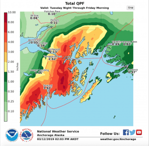
An active weather pattern continues for Eastern Turnagain Arm and another powerful storm is bringing strong winds and heavy snow to our region today. The National Weather Service has issued a Special Weather Statement due to 2-3 ft of snow expected in the mountains of Girdwood, Turnagain Pass and Moose Pass by Friday. Overnight Portage Valley has already seen 0.6 inches SWE (mix of rain and snow) and Turnagain Pass snow stake has ~4 in of new snow overnight. Today 12 inches of snow is expected for Turnagain Pass and Girdwood by early evening and another 1-2 ft of snow is possible overnight. Strong ridgetop winds 30-40 mph from Northeast will continue through the day and build into the 60s mph and gusts in the 80s mph by this evening. This means the avalanche hazard will be increasing throughout the day and natural avalanches will be more likely as today’s storm progresses. The more snow that falls the greater the avalanche hazard. With such strong winds storm slabs could grow to 1-2 ft in the alpine before dark. Below 2000 ft where a stout crust has formed storm slabs could be easily triggered on this slick bed surface as snowfall totals increase. Avoid all avalanche terrain if you see any natural avalanches and be prepared to end your day early due to increasing danger.
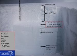
Persistent Slabs: To compound today’s avalanche hazard, there is also weak snow (facets and buried surface hoar) buried under 2-3 ft of new snow from this weekend. Yesterday we heard about a skier partially buried in an avalanche between Placer and Grandview at around 4000 ft on NW aspect. According to a witness in the area the crown was 3 ft deep by 300 ft wide and the skier was partial buried, but okay. This is a good reminder that the size of the avalanche hazard is increasing from large to very large with the addition of more snow and strong wind today. This poor structure is most concerning above 2000 ft where a stout crust formed on Monday night.
South of Turnagain in Summit Lake a variety of old weak layers in the mid and base of the snowpack. The Southerly storm track direction is expected to impact Summit Lake with up to 1-2 ft of new snow by Friday. This wasn’t the case last weekend where only a few inches fell. Be aware that more uncertainty exists in this zone for triggering dangerous avalanche in a variety of old weak layers, and rapid loading from new snow and strong winds could also cause natural avalanches by this evening.
Wet Snow: A mix if rain and snow is expected below 1000 ft. In Portage and Placer Valley where above freezing temperatures mid-day could cause heavy rain, loose-wet avalanches are possible today in lower elevations.
View the full forecast at CNFAIC
Weather
Yesterday: Skies were mostly clear in the morning becoming cloudy by late afternoon. Ridge top winds from the NE were Light becoming 15-25 mph by early afternoon. Temperature remained in low to mid 20s F in upper elevations, ~30F at lower elevations. Overnight snow started falling. Turnagain Pass has an estimated 4 inches of new snow and Alyeska midway station 3 inches new.
Today: A strong storm is tracking over Eastern Turnagain Arm. Heavy snowfall is expected this afternoon through tomorrow morning. A foot of new snow is possible by 8pm and another 1-2 ft is expected overnight. Strong Easterly ridge top winds 30-40 mph will increase into the 60s with gusts in the 80s mph by early evening. Temperatures should remain in the 20s F in the mid and upper elevations, but above freezing temps and rain is possible near sea level. Rain/snow line could reach as high as 1000 ft by this evening.
Tomorrow: Heavy snow fall is expected to decrease by early afternoon tomorrow, but snow showers will continue through the day. Ridgetop winds are also expected to decrease throughout the day from strong to moderate by the evening before another round of precip and strong winds pick up again Friday evening into Saturday. More storms are expected over the weekend and into next week.
*Seattle Ridge anemometer was freed of rime and wind data started around 4pm on 3/12/19
Additional Information