Valdez
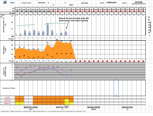
Above 4,000ftHigh
2,000 to 4,000ftHigh
Below 2,000ftHigh
Degrees of Avalanche Danger
Avalanche Problems
Problem 1

Likelihood:
- Almost Certain
- Very Likely
- Likely
- Possible
- Unlikely
Size:
- Historic
- Very Large
- Large
- Small
Trend
- Increasing
- Steady
- Decreasing
Problem 2

Likelihood:
- Almost Certain
- Very Likely
- Likely
- Possible
- Unlikely
Size:
- Historic
- Very Large
- Large
- Small
Trend
- Increasing
- Steady
- Decreasing
Problem 3

Likelihood:
- Almost Certain
- Very Likely
- Likely
- Possible
- Unlikely
Size:
- Historic
- Very Large
- Large
- Small
Trend
- Increasing
- Steady
- Decreasing
Avalanche Activity
2/14: Dry loose D1-2 natural avalanches were observed running over the wowie zowie ice climb in Mineral creek.
2/13: Natural and human triggered D1 avalanches were observed in keystone canyon.
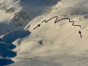
2/12: A D3 avalanche at mile post 38 hit the Richardson highway and closed the road. Released on a south aspect in the upper elevation start zones, ~5500′, and stepped down around 4-4500′. Further DOT mitigation efforts on Three pigs and 40.5 mile produced no results.
2/11: Small avalanche observed on NW aspect of Dimond “promise land”, ~5500′ , R1-D1.5, wind loaded pocket just off ridge line.
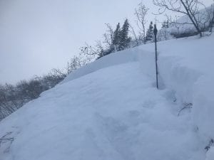
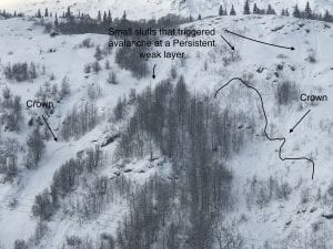
-Several avalanches observed on steep benches below 2500′ on S aspect hippie ridge around MP 35. Only ran height of bench ~100′, but had long connected crowns suggesting these failed on a Persistent weak layer. Crowns ~2′ deep.
2/10: Skies cleared yesterday, from 46 mile to Thompson Pass very few natural avalanches were seen from the 27 inches of snow that fell from 2/8- 2/10.
2/8: Many full path avalanches were reported running around Valdez glacier lake.
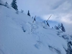
2/6: 2 remote triggered avalanches on RFS at 1800-2000′.
- SS-ARr-R1-D1-O, N aspect, 60′ wide, 50 cm crown, 1800′, failed on buried near surface facets.
- SS-ARr-R3-D1.5-O, N aspect, 100′ wide, ~60 cm crown, 2000′, failed on buried near surface facets.
Photo of 1st remote trigger listed
-Natural avalanches observed on south aspect at mile 40, ~1800′, 1-2 feet deep and ~100′ wide. SS-NL-R2-D1.5-O. These were triggered by small snow sluffs.
2/2: Numerous Small pockets of unsupported terrain released naturally in the tsaina valley below 2000′, 2′ deep.
1/27-1/30: Naturals were observed on RFS, N aspect ~6000′,
Avalanches were also observed on -40.5 mile, ~5000′ ,W aspect, 60 m crown
– 2 paths on Three Pigs, ~5000′, SE aspect, ran into the top 1/3 of aprons.
– 3 slides on Billy Mitchell ranging from 3000′-6000′, NW- N aspect. The most significant was on the upper bowl of cry babys, ~5000′, ~200 m crown, 1-2 meters deep.
1/23- Found fresh debris in a gully off point 3848′ behind the airport. D2, ran ~2000′.
~ 1/10- There have been several natural windslabs that have released in the Thompson Pass region:
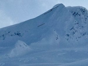
-South slope of catchers mitt, near 27 mile icefall,~3500′, ~300m wide ,~3′ deep, ran 500′ HS-N-R3-D2.5. Photo shows extent of crown, which may have been bigger and is now filled in by wind transported snow.
– Gully Between Little and Big Oddessey, NW, 4000′, ~60 M wide, ~2-4′ crown, ran 1000′
-Averys, ~4000′, SW, ~70 M wide, ran ~1000′
1/11- Two natural wind slab avalanches observed at moonlight basin, 2500′-2800′, S aspect.
The first was on the small last roll before the road and had debris chunks up to 3′ deep “crown filled in by wind”, 200′ wide.
The second was in a cross loaded gully ~ 300′ above the road, with a crown up to ~10′ deep, ~100′ wide. 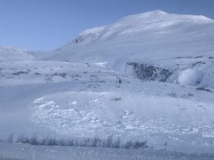
Weather
2/19: The current storm we are experiencing will exit today, with the next storm right on its’ heels. Expect continued heavy snowfall for Thomson Pass and moderate to strong south winds. Snow is forecasted to return to sea level by tonight.
The Thompson Pass Mountain Forecast covers the mountains (above
1000 ft) surrounding Keystone Canyon through Thompson Pass to
Worthington Glacier.

This forecast is for use in snow safety activities and emergency
management.

                   Today        Tonight

Temp at 1000`      34 F         25 F

Temp at 3000`      22-29 F      24 F

Chance of precip   100%         100%

Precip amount
(above 1000 FT)    0.52 in      0.23 in

Snow amount
(above 1000 FT)    3-5 in       2-4 in

Snow level         700 ft       sea level

Wind 3000` ridges  S 11-21 mph  S 6-15 mph

Remarks...None.
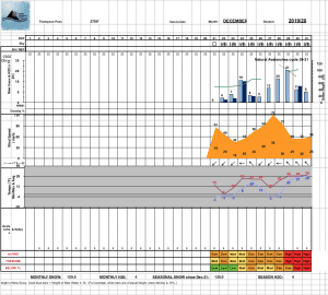
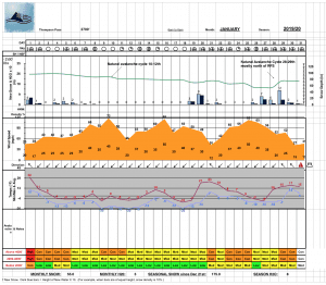
| 24h snowfall (inches) | HN24W (inches)* | Hi Temp (F) | Low Temp (F) | February snowfall | Season Snowfall | Snow height | |
| Valdez | 1.5 | 1.3 | 32 | 30 | 38 | 145 | 55 |
| 46 mile | 5 | .85 | 43 | 32 | 23 | 84 | 28 |
|
Thompson Pass “DOT” |
19 | 2.16 | 29 | 25 | 84 | 441 | 100 |
HN24W= total water received last 24 hours in inches
Thompson Pass weather history 19/20 season beginning 12/21 through 1/23. Click on links below to see full size image.
Additional Information
Weak layers exist in our snowpack. Despite these weaknesses we have had minimal natural and human triggered avalanche activity. Incremental storms have not been enough to overload weak layers and create a widespread avalanche cycle since new years.
On 2/12 a natural D3 hard slab avalanche ran full path at 38 mile and closed the Richardson Highway. This natural released at a weak layer deep within our snowpack. This event is a clear indication that weak layers deep in our snowpack could still be reactive and produce very large destructive avalanches.
Significant storms will impact our area this week. This series of storms will be a real test of the strength of weak layers in our snowpack. Stay away from avalanche terrain while this test is underway.
Forecast Confidence is Moderate.
Resolution is Low
There have been limited observations from interior locations due to low snow at lower elevations. Use caution if you travel in these areas.
If you see something in the mountains that could contribute to this forecast, leave a public observation. The more observations we receive, the better we can tune our forecast. If you would rather not post an observation publicly, feel free to send me an email at [email protected]
Be aware that the elevation bands have changed on our website. Low is now below 2000′, Mid is 2000-4000′ and high is 4000′ and above.
Send in your best mountain recreation photos to [email protected] so we can post a photo of the week!
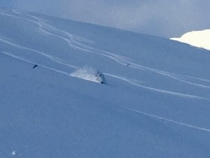
Photo of the Week
Thanks to Spencer Byson for sending in this photo!
Alerts
The avalanche hazard is high at all elevations. Thompson pass has received 18 inches of snow in the last 24 hours with 2.2″ of SWE. Continued heavy snowfall and moderate to strong south winds will continue to stress the snowpack. Natural avalanches are likely today. Avoid travel in and below avalanche terrain.