Valdez
Above 3,000ftModerate
1,500 to 3,000ftModerate
Below 1,500ftModerate
The Avy Rose shows the forecasted danger by elevation and aspect. It adds more detail about where you are likely to find the dangers mentioned in the forecast. The inner circle shows upper elevations (mountain top), the second circle is middle elevations, and the outer circle represents lower elevations. Think of the Rose as a birds-eye view of a mountain, looking down from above. The rose allows our forecasters to visually show you which parts of the mountain they are most concerned about.
Degrees of Avalanche Danger
Avalanche Problems
Problem 1
Old wind slabs formed on 12/17 have settled, gained strength and become unreactive. Light snow began on 12/19 with 1-3 inches of accumulation while moderate north winds continued. This is forming thin windslabs on lee aspects which has caused the top few inches of snow to become upside down.
At this point this avalanche problem does not pose a significant hazard to backcountry travelers in most locations. Isolated areas may have received more snow with specific terrain features being loaded deeper. Poor terrain choices, such as skiing a steep lee slope above a terrain trap would be an instance where this avalanche problem could pose a significant hazard.
Anticipate the hazard for this avalanche problem to increase as more snow becomes available for transport and deeper slabs form. To evaluate the potential hazard of this problem, check the depth and sensitivity of fresh/forming windslabs.

Likelihood:
- Almost Certain
- Very Likely
- Likely
- Possible
- Unlikely
Size:
- Historic
- Very Large
- Large
- Small
Trend
- Increasing
- Steady
- Decreasing
Problem 2
Faceted snow near the base of the snowpack has been identified in all three forecast zones. In most locations above brush line, faceted snow is capped by pencil-knife hard wind affected snow. This has created a strong bridging affect making a person or machines weight unlikely to directly affect these layers.
Our area received 3-4 inches of snow water equivalent over a 5 day period beginning 12/11. This put significant stress on these weak layers. Natural avalanches did occur, but activity was not widespread and natural avalanches were mostly confined to the storm snow. This points to the strength of the wind hardened snow overlying the weak facets at the base of our snowpack.
It has been five days since the last significant snowfall event and stability tests that directly target these layers have not produced propagation since. One exception was an interior location just north of our continental forecast zone where propagation in stability tests still existed on 12/18.
Persistent weak layers are tricky to assess and are notorious for surprising people. As long as temperatures remain cold and our snowpack is thin, these weak layers will continue to lose strength. It is likely that facets will reactivate in the future when stress is being applied through dramatic changes in weather such as: significant snow accumulation, rapid warming and wind loading. Maintaining safe travel protocols such as skiing one at a time and avoiding traveling in or above terrain traps will increase your safety margin.
The most likely areas to trigger a persistent slab avalanche would be in steep terrain that was protected from previous strong winds that have occurred this season. This could be below brushline or in areas of terrain that are typically spared from outflows. The Continental zone remains suspect as this area has a weaker snowpack and generally receives less wind, which would decrease the bridging affect mentioned above.

Likelihood:
- Almost Certain
- Very Likely
- Likely
- Possible
- Unlikely
Size:
- Historic
- Very Large
- Large
- Small
Trend
- Increasing
- Steady
- Decreasing
Avalanche Activity
Below is a summary of observed Avalanche activity from the last 7 days. Avalanches that were noted earlier in the season can be viewed by clicking the link below.
If you trigger or observe a natural avalanche consider leaving a public observation.
12/15- DOT avalanche control work produced several D2-2.5 avalanches from upper elevations of Hogsback and South Three Pigs. Step downs were noted with one slide suspected of failing at the ground.
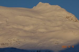
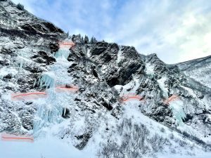
Natural D2-2.5 avalanche activity was observed on Python Buttress north aspect, Berlin Wall northeast aspect, Averys southwest aspect and Girls mountain just above Worthington glacier southwest aspect picture below. There was also a significant amount of avalanche activity in Keystone canyon (Bridal Veil photo below) with at least 1 deep crown reported on the ice climb Gunnison. Most of the avalanches observed involved only storm snow with only a few step downs observed. Exceptions to this include DOT control work and the keystone canyon slide noted above.
Weather
Check out our updated weather tab! A collection of local weather stations are available for viewing with graphs and tabular data included.
NWS Watches and warnings
NONE
NWS Point forecast for Thompson Pass
Date                           Wednesday 12/21/22      Thursday 12/22/22
Time (LT)          18    00    06    12    18    00    06    12    18
Cloud Cover        OV    OV    OV    OV    OV    OV    SC    SC    FW
Cloud Cover (%)    70    70    70    70    70    75    30    25    25
Temperature         1    -3    -5    -5    -2    -2     3     5     6
Min/Max Temp                   -8          -1          -7           6
Wind Dir           NE    NE    NE    NE    NE    NE    NE    NE     N
Wind (mph)         12    11     8    11    12     9    11    13    16
Wind Gust (mph)    35    34    26                            31    32
Precip Prob (%)    50    40    20    30    40    20     5     0     5
Precip Type         S     S     S     S     S     S
12 Hour QPF                  0.10        0.04        0.03        0.00
12 Hour Snow                  0.0         0.0         0.0         0.0
Snow Level (kft)  0.0   0.0   0.0   0.0   0.0   0.0   0.0   0.0   0.0
Click on link below for Thompson Pass weather history graph:

| Date:
12/21 |
24 hr snow | HN24W* | High temp | Low temp | 72 hour SWE* | December snowfall | Seasonal snowfall | Snowpack Depth |
| Valdez | 1 | .1 | 11 | 6 | .1 | 50 | 85 | 38 |
| Thompson pass | 3 | .085 | -13 | -21 | .085 | 73 | 175 | 32 |
| 46 mile | N/O | N/O | -10 | -17 | N/O | ~22 | ~29** | 27 |
*HN24W- 24 hour Snow water equivalent in inches
*SWE– Snow water equivalent
**46 mile seasonal snowfall total begins December 1st.
Additional Information
Click on the link below for a running summary of this seasons weather history of our area.
Announcements
The avalanche hazard is moderate at all elevations. Light snowfall along with moderate north winds will be forming fresh wind slabs that could be triggered by a person up to 6 inches deep. The hazard will be increasing if more snow accumulates and outflow winds continue.
Posted by Gareth Brown 12/21 8:00am.
For a description of current avalanche problems, weather information, season history and more click the (+ full forecast) button. Avalanche forecasts will be issued Wednesday-Sunday.