Valdez
Above 3,000ftModerate
1,500 to 3,000ftModerate
Below 1,500ftModerate
Degrees of Avalanche Danger
Avalanche Problems
Problem 1
Today it will remain possible to trigger small wind slabs up to one foot in depth in steep terrain near ridge lines and in cross loaded gullies. Stability tests have recently shown sensitive snow within the top 4-8 inches of the snowpack. This has only been found to be a concern were it is capped by stiffer wind slabs. Without a wind slab, there is no slab present within this top layer of snow.
Shallow wind slabs will slowly be gaining strength, although it will still be wise to pay attention to their depth and sensitivity in the area that you choose to travel. In areas unaffected by wind, stable conditions continue to be observed and reported in all of our forecast zones. The exception would have been yesterday near the coast on solar aspects where a significant amount of wet loose activity occurred. This activity is not expected to continue today. Low elevation coastal solar aspects will have a melt freeze crust in place that has added strength to the surface and overcast skies will limit the suns’ affect.

Likelihood:
- Almost Certain
- Very Likely
- Likely
- Possible
- Unlikely
Size:
- Historic
- Very Large
- Large
- Small
Trend
- Increasing
- Steady
- Decreasing
Problem 2
Continued light incremental snowfall has put additional stress on a decomposing rain crust that exists below 2500′ that has recently showed signs of instability near the coast. This layer exists in all three forecast zones but has only been found to be a concern in the Maritime zone, this includes Keystone Canyon. This rain crust has lost strength since it has formed and has created a weak layer. It will be possible for the 1/25 rain crust to act as a failure plane in steep terrain at low elevations in the maritime climate zone. Unsupported terrain will be the most suspect.
Watch for signs of instability such as shooting cracks and collapsing. Digging snowpits to assess stability in the area you choose to travel is a good idea if choosing to travel in steep terrain at low elevations in the Maritime climate zone.

Likelihood:
- Almost Certain
- Very Likely
- Likely
- Possible
- Unlikely
Size:
- Historic
- Very Large
- Large
- Small
Trend
- Increasing
- Steady
- Decreasing
Problem 3
Weak snow continues to exist near the base of our snowpack in all three climate zones. The last recorded avalanche activity at this layer occurred during the 1/23-25 storm on Nicks Buttress / ~3500’/ north aspect (see avalanche activity section). This layer is believed to be dormant as there has not been deep avalanche activity for 3 weeks, and only 2 observed in 2 months. Human triggered avalanches are currently unlikely to occur that fail on weak snow near the base of our snowpack.
Faceted snow near the ground has been found to vary significantly from place to place. In most locations this snow has been found to be rounding (gaining strength) and unreactive in stability tests. In thin areas of the snowpack these facets are significantly more developed. Unlikely does not mean impossible, if a person were to affect weak snow near the ground it would be in areas where the snowpack is thin.
If you find it is possible to push a ski pole to the ground in areas you travel. Assume that a weak faceted snowpack exists in that location, that could act as a trigger point. An example of the difference in faceted snow that has been recently found can be seen below.
Depth hoar from Nicks Buttress ~4000′ North aspect 1/31. This was from an area where the snowpack 3 feet deep.

Rounding depth hoar on Cracked Ice / north aspect/ 3000′ on 2/11. This was from an area where the snowpack was 7 feet deep

Likelihood:
- Almost Certain
- Very Likely
- Likely
- Possible
- Unlikely
Size:
- Historic
- Very Large
- Large
- Small
Trend
- Increasing
- Steady
- Decreasing
Avalanche Activity
Below is a summary of observed Avalanche activity from the last 7 days. Avalanches that were noted earlier in the season can be viewed by clicking the link below.
If you trigger or observe an avalanche consider leaving a public observation.
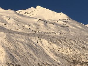
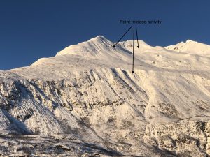
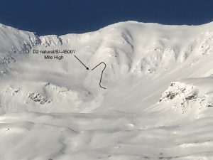
2/15- The sun came out in full force after 6 inches of new snow and produced a significant amount of point release wet/loose activity near the coast on solar aspects. 2- D2’s were also noted in the mid and high elevation band of town mountain and Mile high.
2/9- Several small (D1) natural avalanches were observed that failed on steep wind loaded terrain.
Weather
Check out our updated weather tab! A collection of local weather stations are available for viewing with graphs and tabular data included.
NWS Watches and warnings
NONE
NWS Point forecast for Thompson Pass
Date               Thursday 02/16/23       Friday 02/17/23
Time (LT)          06    12    18    00    06    12    18    00    06
Cloud Cover        OV    OV    OV    OV    OV    OV    OV    FW    OV
Cloud Cover (%)    75    85    70    90   100   100    70    15    95
Temperature        12    20    18    15    18    23    23    18    17
Max/Min Temp                   22          15          26          16
Wind Dir           SE     S     S    SE     E     E     W    SW     S
Wind (mph)          5     8     6     8    14    14     5     4     5
Wind Gust (mph)    18
Precip Prob (%)    20    70    40    60    80    80    30    10    40
Precip Type         S     S     S     S     S     S     S           S
12 Hour QPF                  0.07        0.10        0.18        0.03
12 Hour Snow                  0.7         1.4         3.2         0.0
Snow Level (kft)  0.0   0.0   0.0   0.0   0.0   0.0   0.0   0.0   0.0
Click on link below for Thompson Pass weather history graph:

| Date:
02/16 |
24 hr snow | HN24W* | High temp | Low temp | 72 hour SWE* | February snowfall | Seasonal snowfall | Snowpack Depth |
| Valdez | 0 | 0 | 32 | 8 | .6 | 60 | 205 | 67 |
| Thompson pass | 0 | 0 | N/O | N/O | N/O | 67 | 354 | 66 |
| 46 mile | N/O | N/O | 27 | -8 | N/O | ~16 | ~85** | 46 |
*HN24W- 24 hour Snow water equivalent in inches
*SWE– Snow water equivalent
**46 mile seasonal snowfall total begins December 1st.
Additional Information
Click on the link below for a running summary of the seasons weather history.
Announcements
The avalanche hazard is moderate at all elevations in the maritime climate zone. Human triggered avalanches up to 1 foot in depth are possible. It remains possible to trigger thin wind slabs in steep terrain above 2500 feet. Below 2500 feet weak snow exists near the coast buried 2-3 feet in depth that could be sensitive in steep and/or unsupported terrain. Shooting cracks and collapsing will be an indication that a slope steeper than 32° has the potential to produce an avalanche. Wet loose avalanches that occurred 2/15 on solar aspects near the coast are not expected to occur today as cloud cover will limit the suns affect.
Posted by Gareth Brown 02/16 8:00 am.
For a description of current avalanche problems, weather information, season history and more click the (+ full forecast) button. Avalanche forecasts will be issued Wednesday-Sunday.
If you have pictures of recent natural or human triggered avalanches or notice signs of instability such as shooting cracks or collapsing, leave an observation to help improve forecast accuracy.