Valdez
Above 3,000ftConsiderable
1,500 to 3,000ftConsiderable
Below 1,500ftConsiderable
Degrees of Avalanche Danger
Avalanche Problems
Problem 1
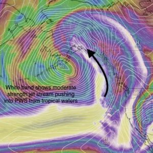
An atmospheric river is forecasted to affect our area with 1-3 feet of snow expected over the next 48 hours at upper elevations. A sharp increase in temperatures will accompany this storm that may drive the freezing line up to 2000′ by midday.
Heavy new snow and rain will be falling on 4-12 inches of dry snow that is sitting on a low friction (slick) bed surface. This will create top heavy storm slabs that will be initially sensitive to human and machine triggers 1-2 feet in depth on all aspects and elevations. If the next 24-48 hours of weather occurs as predicted, we will have all three ingredients necessary to produce avalanches. Bed surface, weak layer and slab.
Conservative terrain choices and cautious route finding will be necessary for safe travel in avalanche terrain tomorrow. Watch for signs of instability such as shooting cracks, collapsing and avalanche activity that would indicate unstable snow.
If we get a much stronger storm than forecasted, the avalanche hazard may rise to HIGH in some locations.

Likelihood:
- Almost Certain
- Very Likely
- Likely
- Possible
- Unlikely
Size:
- Historic
- Very Large
- Large
- Small
Trend
- Increasing
- Steady
- Decreasing
Problem 2
The potential for wet loose avalanches will be on the increase as freezing levels rise and we receive rain on dry snow below 1500′. Even small wet loose avalanches in steep terrain have the potential to entrain significant mass to knock a person off their feet and carry them into potentially dangerous terrain/ exposure. This should be a consideration for ice climbers tomorrow.

Likelihood:
- Almost Certain
- Very Likely
- Likely
- Possible
- Unlikely
Size:
- Historic
- Very Large
- Large
- Small
Trend
- Increasing
- Steady
- Decreasing
Problem 3
Early season rain events followed by mostly cold, dry and windy weather November through December have promoted facet growth in the bottom half of our snowpack. This weak snow has remained dormant over the last 10 days as no major loading events have occurred.
Heavy precipitation and rising temperatures will return to the Valdez/ Thompson Pass region and have the potential to reactivate weak layers in our lower snowpack. It is very difficult to predict how much snow/weight it will take to make these persistent weak layers reactive.
The predicted storm totals of the current storm is unlikely to cause a widespread natural avalanche cycle at these deep layers above brushline. This is due to very strong snow that is capping these weaknesses caused by previous strong wind events that have been frequent through the early season. Although, the potential cannot be ruled out.
Below brushline failures at persistent weak layers will be possible in isolated locations. These include steep slopes below 2500′ with a lack of anchors (alders) EX: steep terrain into gullies or canyons. A lack of very hard wind damaged snow above the October facets will make these areas easier to affect.

Faceted snow near the ground from Crudbusters (continental zone) below brush line.

Likelihood:
- Almost Certain
- Very Likely
- Likely
- Possible
- Unlikely
Size:
- Historic
- Very Large
- Large
- Small
Trend
- Increasing
- Steady
- Decreasing
Avalanche Activity
Below is a summary of observed Avalanche activity from the last 7 days. Avalanches that were noted earlier in the season can be viewed by clicking the link below.
If you trigger or observe a natural avalanche consider leaving a public observation.
No recent avalanche activity has been recorded in the last 7 days.
Weather
Check out our updated weather tab! A collection of local weather stations are available for viewing with graphs and tabular data included.
NWS Watches and warnings
Northeast Prince William Sound-
Including the cities of Valdez and Thompson Pass
449 AM AKST Sun Jan 1 2023

...WINTER WEATHER ADVISORY REMAINS IN EFFECT UNTIL 6 PM AKST THIS
EVENING...

* WHAT...Blowing snow and snow expected. Total snow
  accumulations of 6 to 12 inches. Winds gusting as high as 45
  mph.

* WHERE...Thompson Pass.

* WHEN...Until 6 PM AKST today.

* IMPACTS...Travel could be extremely hazardous due to blowing
  snow with low visibility down to a half mile.

* ADDITIONAL DETAILS...Snow will transition to a rain snow mix by
  this afternoon. The winds combined with the snow will create low
  visibility down to a half mile due to blowing snow.
  Additionally, as snow transitions to a wintry mix, afternoon
  travel could be especially difficult due to slushy and icy
  conditions.
NWS Point forecast for Thompson Pass
Date               Sunday 01/01/23         Monday 01/02/23
Time (LT)          06    12    18    00    06    12    18    00    06
Cloud Cover        OV    OV    OV    OV    OV    OV    OV    OV    OV
Cloud Cover (%)   100   100   100   100   100   100   100   100    95
Temperature        21    30    32    28    27    31    31    26    26
Max/Min Temp                   33          24          32          21
Wind Dir            E    SE    SE    SE    SE    SE    SE    SE    SE
Wind (mph)         20    33    24    14    19    12     8     5     4
Wind Gust (mph)    40    55    35
Precip Prob (%)   100   100   100   100    90   100    70    70    60
Precip Type         S     S     S     S     S     S     S     S     S
12 Hour QPF                  0.79        0.50        0.35        0.14
12 Hour Snow                  8.8         4.9         3.7         1.6
Snow Level (kft)  1.7   2.1   1.9   1.8   1.5   0.9   0.8   0.4   0.4
Click on link below for Thompson Pass weather history graph:

| Date:
01/01 |
24 hr snow | HN24W* | High temp | Low temp | 72 hour SWE* | January snowfall | Seasonal snowfall | Snowpack Depth |
| Valdez | 39 | 28 | 96 | 40 | ||||
| Thompson pass | 6 | ~.5 | 27 | 8 | .15 | 6 | 200 | 31 |
| 46 mile | 6 | .5 | 14 | 8 | .5 | 6 | ~42** | 36 |
*HN24W- 24 hour Snow water equivalent in inches
*SWE– Snow water equivalent
**46 mile seasonal snowfall total begins December 1st.
Additional Information
Click on the link below for a running summary of the seasons weather history.
Announcements
The avalanche hazard is Considerable at all elevations. Today, a strong storm will bring heavy snowfall to upper elevations with snow turning to rain below 1500′. This abrupt change in weather will make human triggered avalanches 1-2 feet in depth likely and natural avalanches possible.
Posted by Gareth Brown 01/01 8:00 am.
For a description of current avalanche problems, weather information, season history and more click the (+ full forecast) button. Avalanche forecasts will be issued Wednesday-Sunday.