Valdez
Above 4,000ftModerate
2,000 to 4,000ftModerate
Below 2,000ftLow
Degrees of Avalanche Danger
Avalanche Problems
Problem 1
Incremental snowfall and mild temperatures continue to build our snowpack. Today instabilities are expected to be shallow (less than 1 foot) and concentrated to areas where the surface snow has been affected by recent winds. Winds have switched direction multiple times over the last 48 hours creating the possibility for shallow wind slabs to exist on a variety of aspects. On 2/14 near Thompson Pass wind slabs that were created from the north winds 2/11-12 were found to be stubborn to triggers and gaining strength.
Fresh slab development from south wind and light snowfall was forming a shallow layer (2-4 inches) of upside down snow at the surface that could be reactive to human triggers where it is found to be deeper. Human triggered avalanches are possible up to 1 foot in depth in specific areas. These areas include cross loaded terrain, steep slopes near high elevation ridge lines and any terrain steeper than 32° where more than 6″ of hard snow exist over softer snow beneath. Pay attention to wind slab depth and sensitivity in the area you choose to travel. Shooting cracks in the surface snow is a bullseye indication that unstable snow exists at the surface.
Better riding conditions and stability will be found in areas protected from recent winds.

Likelihood:
- Almost Certain
- Very Likely
- Likely
- Possible
- Unlikely
Size:
- Historic
- Very Large
- Large
- Small
Trend
- Increasing
- Steady
- Decreasing
Problem 2
Continued light incremental snowfall has put additional stress on a decomposing rain crust that exists below 2500′ that has recently showed signs of instability near the coast. This layer exists in all three forecast zones but has only been found to be a concern in the Maritime zone, this includes Keystone Canyon. This rain crust has lost strength since it has formed and has created a weak layer. It will be possible for the 1/25 rain crust to act as a failure plane in steep terrain at low elevations in the maritime climate zone. Unsupported terrain will be the most suspect.
Watch for signs of instability such as shooting cracks and collapsing. Digging snowpits to assess stability in the area you choose to travel is a good idea if choosing to travel in steep terrain at low elevations in the Maritime climate zone.

Likelihood:
- Almost Certain
- Very Likely
- Likely
- Possible
- Unlikely
Size:
- Historic
- Very Large
- Large
- Small
Trend
- Increasing
- Steady
- Decreasing
Problem 3
Weak snow continues to exist near the base of our snowpack in all three climate zones. The last recorded avalanche activity at this layer occurred during the 1/23-25 storm on Nicks Buttress / ~3500’/ north aspect (see avalanche activity section). This layer is believed to be dormant as there has not been deep avalanche activity for 3 weeks, and only 2 observed in 2 months. Human triggered avalanches are currently unlikely to occur that fail on weak snow near the base of our snowpack.
Faceted snow near the ground has been found to vary significantly from place to place. In most locations this snow has been found to be rounding (gaining strength) and unreactive in stability tests. In thin areas of the snowpack these facets are significantly more developed. Unlikely does not mean impossible, if a person were to affect weak snow near the ground it would be in areas where the snowpack is thin.
If you find it is possible to push a ski pole to the ground in areas you travel. Assume that a weak faceted snowpack exists in that location, that could act as a trigger point. An example of the difference in faceted snow that has been recently found can be seen below.
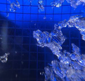
Depth hoar from Nicks Buttress ~4000′ North aspect 1/31. This was from an area where the snowpack 3 feet deep.

Rounding depth hoar on Cracked Ice / north aspect/ 3000′ on 2/11. This was from an area where the snowpack was 7 feet deep

Likelihood:
- Almost Certain
- Very Likely
- Likely
- Possible
- Unlikely
Size:
- Historic
- Very Large
- Large
- Small
Trend
- Increasing
- Steady
- Decreasing
Avalanche Activity
Below is a summary of observed Avalanche activity from the last 7 days. Avalanches that were noted earlier in the season can be viewed by clicking the link below.
If you trigger or observe an avalanche consider leaving a public observation.
2/7- DOT avalanche control work on 2/7 produced several D2-2.5 avalanches. All of these appear to have failed at the new snow/old interface without any step downs observed. Avalanche activity mostly occurred in the mid elevation band 3500′-4000′ on the Buttresses of RFS, Cracked Ice, and Python. The most significant results occurred on Berlin Wall at ~5000′ with a crown that looks to exceed 2 meters. This was likely due to significant wind loading during the storm.
Very little natural avalanche activity was observed.
2/9- Several small (D1) natural avalanches were observed that failed on steep wind loaded terrain.
Weather
Check out our updated weather tab! A collection of local weather stations are available for viewing with graphs and tabular data included.
NWS Watches and warnings
NONE
NWS Point forecast for Thompson Pass
Date               Wednesday 02/15/23      Thursday 02/16/23
Time (LT)          06    12    18    00    06    12    18    00    06
Cloud Cover        OV    BK    BK    BK    OV    OV    OV    OV    OV
Cloud Cover (%)    85    55    55    50    75    95    85   100   100
Temperature        14    18    15     8    11    20    19    16    18
Max/Min Temp                   21           8          23          15
Wind Dir           NE    NE    NE     E    SE     S     S    SE    SE
Wind (mph)          8     4     5     4     5     9     6     6     9
Wind Gust (mph)    29    25    23    28          23
Precip Prob (%)    50    30    30    40    70    80    60    90    90
Precip Type         S     S     S     S     S     S     S     S     S
12 Hour QPF                  0.04        0.04        0.07        0.08
12 Hour Snow                  0.0         0.0         1.3         1.7
Snow Level (kft)  0.0   0.0   0.0   0.0   0.0   0.0   0.0   0.0   0.1
Click on link below for Thompson Pass weather history graph:

| Date:
02/15 |
24 hr snow | HN24W* | High temp | Low temp | 72 hour SWE* | February snowfall | Seasonal snowfall | Snowpack Depth |
| Valdez | 5 | N/O | 29 | 26 | N/O | 42 | 187 | 64 |
| Thompson pass | 2-3 | N/O | N/O | N/O | N/O | 70 | 367 | 66 |
| 46 mile | N/O | N/O | 28 | 15 | N/O | ~16 | ~85** | 46 |
*HN24W- 24 hour Snow water equivalent in inches
*SWE– Snow water equivalent
**46 mile seasonal snowfall total begins December 1st.
Additional Information
Click on the link below for a running summary of the seasons weather history.
Announcements
The avalanche hazard is moderate above 2000′ in the intermountain and continental forecast zones and low below. Human triggered avalanches up to 1 foot in depth are possible. The most likely place to encounter unstable snow will be in areas where surface snow is affected by wind. Shooting cracks and collapsing will be an indication that a slope steeper than 32° has the potential to produce an avalanche.
Posted by Gareth Brown 02/15 8:00 am.
For a description of current avalanche problems, weather information, season history and more click the (+ full forecast) button. Avalanche forecasts will be issued Wednesday-Sunday.
If you have pictures of recent natural or human triggered avalanches or notice signs of instability such as shooting cracks or collapsing, leave an observation to help improve forecast accuracy.