Valdez
Above 4,000ftLow
2,000 to 4,000ftLow
Below 2,000ftLow
Degrees of Avalanche Danger
Avalanche Problems
Problem 1

Likelihood:
- Almost Certain
- Very Likely
- Likely
- Possible
- Unlikely
Size:
- Historic
- Very Large
- Large
- Small
Trend
- Increasing
- Steady
- Decreasing
Problem 2
Likelihood:
- Almost Certain
- Very Likely
- Likely
- Possible
- Unlikely
Size:
- Historic
- Very Large
- Large
- Small
Trend
- Increasing
- Steady
- Decreasing
Problem 3

Likelihood:
- Almost Certain
- Very Likely
- Likely
- Possible
- Unlikely
Size:
- Historic
- Very Large
- Large
- Small
Trend
- Increasing
- Steady
- Decreasing
Avalanche Activity
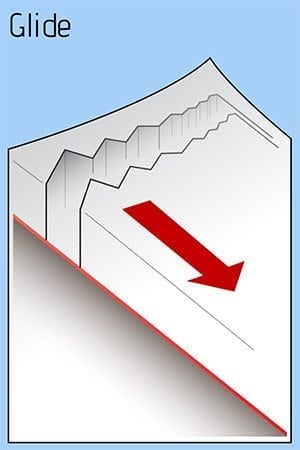
The only reported avalanche was a natural glide avalanche at 31 mile where the Tsaina River meets Richardson Hwy.
Photo thanks to @hewitt_clyde also a video of glide cracks on our FB page: https://www.facebook.com/valdezavycenter/videos/839450486398343/
Please share your field observations including signs of stable snow HERE.
Weather
A small round of clouds and snow is approaching tonight through Friday (Jan 11). The next significant weather change is expected on Saturday night (Jan 12-14).
The most recent NWS rec Forecast can be found HERE:
320 PM AKST Thu Jan 10 2019
The Thompson Pass Mountain Forecast covers the mountains (above
1000 ft) surrounding Keystone Canyon through Thompson Pass to
Worthington Glacier.
                   Tonight      Fri

Temp at 1000`      -9--3 F      14 F

Temp at 3000`      -2-10 F      3-12 F

Chance of precip   0%           30%

Precip amount
(above 1000 FT)    0.00 in      0.06 in

Snow amount
(above 1000 FT)    0 in         0-1 in

Snow level         sea level    sea level

Wind 3000` ridges  NE 5-20 mph  SE 5-10 mph
Additional Information
SNOWPACK BIG PICTURE: The region has been high and dry, cold, and dry, since Jan 5th with moderate+ north winds blowing the New Year’s storms’ snow and building wind slabs. The New Year’s Eve storm brought nearly 2.5″ of SWE to Valdez and almost another 1″ on the 2-3rd of January. The rain line was 1200′ during the last storm (which has now formed a 1-3″ crust locking up all the snow beneath it). That is a LOT of snow and rain in 5 days and it accumulated to over 3′ above 2000′ near Thompson Pass. Both of these storms had little wind. Above 4000′ the snowpack averages over 300cm deep and has good strength and structure (few lemons). Below 4000′, the snowpack is significantly shallower and has more problem layers: facet-crust combos and BASEL facets (all the way to sea level).
If you get out riding, please send in an observation.
Do a rescue practice with your partners. Always carry a beacon, shovel, and probe, and KNOW HOW TO USE THEM.
Practice good risk management, which means only expose one person at a time to slopes 30 degrees and steeper, make group communication and unanimous decision making a priority, and choose your terrain wisely: eliminating unnecessary exposure and planning out your safe zones and escape routes.
Announcements
The current avalanche hazard rating is LOW across all elevations in the Valdez region. Click FULL FORECAST for more information and please share your field observations HERE.
There are a lot of events coming up in January, check out our Facebook page for the complete list.