Valdez
Above 4,000ftConsiderable
2,000 to 4,000ftModerate
Below 2,000ftModerate
Degrees of Avalanche Danger
Avalanche Problems
Problem 1
Snowfall returned stronger than forecasted to our area on 4/22 with 9 inches of new snow recorded at the Nicks snotel at 4200′. This new snow is falling on a layer of surface hoar at upper elevations on shaded aspects and various melt/ freeze crusts in other places. Surface hoar was found to be widespread prior to 4/22 on shaded upper elevation terrain with grains up to 1 cm observed. Areas where the new snow is overlying surface hoar will be the most prone to human triggered avalanches.
Today it will be very important to pay attention to new snowfall amounts and what type of interface it has been deposited on (Surface Hoar, melt freeze crust). Be aware that the sensitivity of new snow/old interface will likely vary spatial (from place to place) with different degrees of sensitivity possible even with slight changes in aspect. The most sensitive areas are expected to be: places that received the greatest storm totals, high elevation north facing terrain (where surface hoar is now buried), and slopes that are being actively or recently loaded by northeast winds.
The sensitivity of this problem is expected to be lower at mid-low elevations where new snow amounts are lower, surface hoar likely doesnt exist and warmer temperatures on 4/22 promoted better bonding. Light snowfall is forecasted to continue today as well as more storms on tap through mid week. Expect for storm slabs to slowly build in depth keeping the avalanche hazard elevated in areas where 4/22 buried surface hoar exists.

Likelihood:
- Almost Certain
- Very Likely
- Likely
- Possible
- Unlikely
Size:
- Historic
- Very Large
- Large
- Small
Trend
- Increasing
- Steady
- Decreasing
Problem 2
The degree of wet loose avalanche activity that occurs today will depend on if the clouds break and the sun is able to pop out. New snow from 4/22 will easily be affected on steep solar aspects especially at low-mid elevations that are receiving direct sun. If today remains overcast the potential for wet loose avalanche activity will be lower, although still possible on E-S-W aspects below 4000′.
Wet loose avalanches occur when the surface of the snow is heated up, causing the snow to become moist-wet at the surface and lose strength. This process is accentuated on steep rocky slopes that are facing the sun. This type of avalanche problem often starts out with a small point release, which then entrains snow as it moves down hill. The size/ volume of slides that are possible will directly correlate with the size/ relief of the slope, the steepness and the degree to which the surface has been heated. This avalanche problem can present as very small harmless point releases to very large destructive avalanches that have the potential to step down to deeper layers in the snowpack.
The way to manage this problem is pretty simple. Pay attention to aspect, slopes that are directly facing the sun will be the ones heating up the most. East aspects are the first to heat up during the day followed by south and then west. Realize that even a slight aspect change can make a big difference when it comes to wet loose likelihood during this time of year. Ask yourself, what is the sun doing to the surface snow on the terrain you choose to travel, and on slopes that are above you. Avoid traveling on or being exposed to steep slopes where the sun is making the surface snow wet.

Likelihood:
- Almost Certain
- Very Likely
- Likely
- Possible
- Unlikely
Size:
- Historic
- Very Large
- Large
- Small
Trend
- Increasing
- Steady
- Decreasing
Problem 3
North winds up to 35 mph is expected today for upper elevation ridge lines, and wind channeled terrain. Expect to encounter fresh wind slabs at upper elevations that are sensitive to human triggers. Wind slabs may be deposited atop surface hoar on high elevation shaded aspects, creating higher sensitivity in those areas. Pay attention to the degree of wind redistribution in the area you choose to travel and watch for signs of instability such as shooting cracks, collapsing and recent avalanche activity.

Likelihood:
- Almost Certain
- Very Likely
- Likely
- Possible
- Unlikely
Size:
- Historic
- Very Large
- Large
- Small
Trend
- Increasing
- Steady
- Decreasing
Problem 4
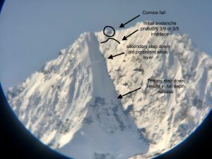
This may be the last problem on the list and least likely to encounter, but it is the most dangerous one. There have been 2 reports in the last week of cornice fall causing very large persistent slabs to full depth avalanches (see avalanche activity section). Avoiding traveling on or exposing yourself to cornices is highly recommended. Lower temperatures and cloud cover will decrease the possibilty for cornice fall today.
Weak snow exists at the base of our snowpack. On 4/15 our area saw the first deep slab activity occur since late February. This occurred on Meteorite (see avalanche activity section) and was a cornice fall that triggered a series of step down avalanches that eventually stepped down to the ground. This is a clear indication that large triggers can have an affect on depth hoar. Increasing temperatures could produce more significant activity later in the season while our snowpack is undergoing a transition from a winter snowpack to a spring one.
This problem is very difficult to assess due its depth and the fact that signs of instability will likely not be present. You can stack the odds in your favor by avoiding steep terrain that is undergoing rapid changes such as strong solar and avoiding exposure to large triggers such as cornices.

Likelihood:
- Almost Certain
- Very Likely
- Likely
- Possible
- Unlikely
Size:
- Historic
- Very Large
- Large
- Small
Trend
- Increasing
- Steady
- Decreasing
Avalanche Activity
Below is a summary of observed Avalanche activity from the last 7 days. Avalanches that were noted earlier in the season can be viewed by clicking the link below.
If you trigger or observe an avalanche consider leaving a public observation.
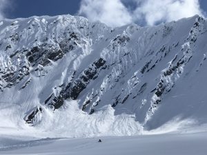
4/17- Large natural avalanche reported on the upper Tasnuna just east of “The Wall”. Cornice fall was likely the initial trigger with other sympathetic avalanches occurring as well as full depth step downs. SS-Nc-R2.5-D3
– Skier triggered avalanche reported in the Tasnuna valley “The Hammer” SS-ASu-D2-I down 40 cms on 4/7 buried surface hoar/ NE aspect ~5500′. 5th Skier on slope was caught and partially buried in a crevasse/ skier did not sustain any major injuries.
4/15- A cornice fall produced a series of step down avalanches on Meteorite which resulted in failure at the ground. This intiatied as a cornice fall at 6500′ that triggered an avalanche most likely at the 3/9 interface which then stepped down to a persistent slab around 6100′ NE and stepped down to the ground at 5600′ NE.
SS/HS-NC-D3-O/G 6200′ NE, step down to ground ~5600′ NE
Weather
Check out our updated weather tab! A collection of local weather stations are available for viewing with graphs and tabular data included.
NWS Watches, warnings and advisories
NONE
NWS Point forecast for Thompson Pass
Date                     Sunday 04/23/23         Monday 04/24/23
Time (LT)          04    10    16    22    04    10    16    22    04
Cloud Cover        OV    OV    OV    OV    OV    OV    OV    OV    OV
Cloud Cover (%)    85    80    75    80    80    90    90    85    80
Temperature        23    24    30    23    14    20    32    29    26
Max/Min Temp                   32          13          33          25
Wind Dir           NE    NE    NE     N    NE    NE    NE     S    SE
Wind (mph)         20    20    24    27    24    17     6     4     6
Wind Gust (mph)    40
Precip Prob (%)    50    10    10     5     5     5    70    30    20
Precip Type         S     S     S                       S     S     S
12 Hour QPF                  0.03        0.00        0.01        0.09
12 Hour Snow                  0.0         0.0         0.0         0.4
Snow Level (kft)  0.0   0.0   0.2   0.1   0.0   0.1   0.5   0.6   0.2
Click on link below for Thompson Pass weather history graph:

| Date:
04/22 |
24 hr snow | HN24W* | High temp | Low temp | 72 hour SWE* | April snowfall | Seasonal snowfall | Snowpack Depth |
| Valdez | 0 | 0 | 51 | 34 | 0 | 11 | 248 | 37 |
| Thompson Pass | ~4 | 0 | N/O | N/O | N/O | 12 | 438 | N/O |
| 46 mile | Trace | .2 | 47 | 28 | .2 | ~5 | ~117** | 42 |
*HN24W- 24 hour Snow water equivalent in inches
*SWE– Snow water equivalent
**46 mile seasonal snowfall total begins December 1st.
Additional Information
Click on the link below for a running summary of the seasons weather history.
Announcements
The avalanche hazard is Considerable above 4000 feet and moderate below. Human triggered avalanches are likely in upper elevations that received more than 8 inches of new snow. New snow has been deposited on a potentially dangerous weak layer on shaded upper elevation terrain. This will make storm slabs more sensitive to human triggers than what is typical. Moderate north winds are forecasted to increase today which will build wind slabs on the lee side of high elevation ridge lines and cross loaded terrain. Pay attention to new snow depths and the sensitivity to new snow at the interface of the old snow. Avoid traveling on or being exposed to slopes where the sun is making the snow surface wet.
Posted by Gareth Brown 04/23 8:00 am.
For a description of current avalanche problems, weather information, season history and more click the (+ full forecast) button. Avalanche forecasts will be issued Wednesday-Sunday through April 30th.
If you have pictures of recent natural or human triggered avalanches or notice signs of instability such as shooting cracks or collapsing, leave an observation to help improve forecast accuracy.