Valdez
Above 4,000ftModerate
2,000 to 4,000ftModerate
Below 2,000ftModerate
Degrees of Avalanche Danger
Avalanche Problems
Problem 1
Storm snow avalanches will be likely today in areas that have received more than 8 inches of snow in the last 24 hours. This storm appears to be favoring our Maritime forecast zone with 5 inches at sea level and double that expected above 1500′. Thompson Pass has seen lower amounts at the road, however Nicks snotel at 4200′ has recorded 4-6 new. Additional snowfall of 4-8 inches near the coast with 2-4 inches near Thompson Pass is possible today. Moderate to strong southeast winds accompanied this new snow at upper elevations, which will have formed deeper and stiffer slabs in specific locations.
As stated above, the hazard level will be dictated by the amount of new snow an area has received. This will likely vary fairly significantly within our forecast area. Locations that saw only minor accumulations will maintain a moderate hazard, with old wind loaded slopes being the main concern. In areas with higher snowfall accumulations human triggered slab avalanches will be likely in steep terrain. Wind loaded, convex and unsupported terrain will be the most suspect. Pay attention to the depth and sensitivity of new snow, as well as the amount of wind redistribution that has occurred.

Likelihood:
- Almost Certain
- Very Likely
- Likely
- Possible
- Unlikely
Size:
- Historic
- Very Large
- Large
- Small
Trend
- Increasing
- Steady
- Decreasing
Problem 2
Wet loose activity will be likely today as the sun comes out. New snow will easily be affected if the strong April sun makes an appearance. Steep south aspects will be the first to show activity especially in steep rocky terrain. So far this season wet loose activity has been below average. Generally by this time of year steep solar aspects are beginning to lose mass by way of natural wet loose avalanche activity. Many of these areas are still gaining mass, creating the potential for more substantial activity once temperatures rise to seasonal norms and wet loose/ wet slab activity begins in earnest. Temperatures look to slowly stair step up this week but a drastic change is not yet in the forecast.
Timing is key in avoidance of this avalanche problem. Pay attention to the amount of warmth that is being transferred into the snow surface (Is it becoming moist-wet?). In general, it is recommended to avoid traveling on or being exposed to steep solar aspects as snow surfaces are becoming moist-wet.

Likelihood:
- Almost Certain
- Very Likely
- Likely
- Possible
- Unlikely
Size:
- Historic
- Very Large
- Large
- Small
Trend
- Increasing
- Steady
- Decreasing
Problem 3
Weak snow exists at the base of our snowpack. This weak snow is currently unlikely to be affected due to the strength of old wind affected snow at the 3/17 new/old interface. Depth hoar may become a concern later in the season if our area returns to a period of major snowfall and the very strong wind damaged layer at the new/old interface starts to break down and lose strength within the snowpack. As very hard wind slabs break down within the snowpack, a person or machines weight will have a more direct affect on weak layers at the bottom of the snowpack. In addition, the increasing intensity of the sun will be putting pressure on deep layers during the heat of the day.
This problem is difficult to assess. if we do see deep slab avalanches begin to occur in our forecast zone, they will likely first show up on south aspects. This has not occurred yet, but would be a clear indicator of an increasing potential to see this avalanche problem on other aspects.

Likelihood:
- Almost Certain
- Very Likely
- Likely
- Possible
- Unlikely
Size:
- Historic
- Very Large
- Large
- Small
Trend
- Increasing
- Steady
- Decreasing
Avalanche Activity
Below is a summary of observed Avalanche activity from the last 7 days. Avalanches that were noted earlier in the season can be viewed by clicking the link below.
If you trigger or observe an avalanche consider leaving a public observation.
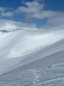
4/9- Skier triggered D2 avalanche reported on a wind loaded NW aspect of Berlin Wall ~5400′. Skier was caught and carried, but not buried/ no injuries.
Small wind loaded pockets D1-1.5 were observed to be sensitive to human triggers in cross loaded terrain on Billy Mitchell.
4/7- Numerous D1-1.5 natural dry loose avalanches observed that occurred mid storm 4/5-6. No step downs observed.
Several small (D1) human triggered avalanches were observed along the road corridor where the new snow had been wind affected.
4/6- Skier triggered D1 reported in Gully 1 on a wind loaded convexity.
4/2- D1.5 skier triggered wind slab avalanche. NW aspect/~4000′.
4/1- Multiple skier triggered D1 avalanches were reported on a variety of aspects. These were wind slabs in the 4-8 inch range.
3/31- Skier triggered avalanche reported at high elevation of the Maritime climate zone. This failed on surface hoar that was buried on 3/30. No skier involvement. Crown depth was 4-8 inches.
3/24- Ski cuts were reported as being productive, with avalanches up to D2 at the 3/21 interface.
3/18-21- Several D1-D2 human triggered avalanches have been reported. For the most part these have been outside our forecast zone and appear to be more likely in areas with either a weaker underlying snowpack (continental zone) or where storm totals were higher (SE of Thompson Pass). Remote triggers have also been reported as the Hamilton storm slab has settled and gained cohesion.
3/17- Multiple D1-D2 natural storm slab avalanches were reported and observed along the road corridor. These all failed within the storm snow with the exception of one deep persistent avalanche reported on Billy Mitchell.
Weather
Check out our updated weather tab! A collection of local weather stations are available for viewing with graphs and tabular data included.
NWS Watches, warnings and advisories
NONE
NWS Point forecast for Thompson Pass
Date                     Wednesday 04/12/23      Thursday 04/13/23
Time (LT)          04    10    16    22    04    10    16    22    04
Cloud Cover        OV    OV    OV    OV    OV    OV    OV    OV    OV
Cloud Cover (%)    90    85    85    85    85    85    90    90    90
Temperature        21    25    30    26    21    24    29    23    20
Max/Min Temp                   31          20          29          19
Wind Dir           SE     E    SW    SW     S     S     S    SE     E
Wind (mph)          9     9     6     8     6     3     8    10    16
Wind Gust (mph)
Precip Prob (%)    70    70    70    50    40    60    60    50    70
Precip Type         S     S     S     S     S     S     S     S     S
12 Hour QPF                  0.08        0.11        0.09        0.10
12 Hour Snow                  1.0         0.8         0.7         1.1
Snow Level (kft)  0.0   0.0   0.3   0.1   0.0   0.0   0.1   0.1   0.1
Click on link below for Thompson Pass weather history graph:

| Date:
04/12 |
24 hr snow | HN24W* | High temp | Low temp | 72 hour SWE* | April snowfall | Seasonal snowfall | Snowpack Depth |
| Valdez | 5 | N/O | 35 | 31 | N/O | 9 | 246 | 47 |
| Thompson Pass | 1 | .1 | N/O | N/O | .1 | 10 | 438 | N/O |
| 46 mile | 0 | 0 | 38 | 21 | 0 | 5 | ~116** | 50 |
*HN24W- 24 hour Snow water equivalent in inches
*SWE– Snow water equivalent
**46 mile seasonal snowfall total begins December 1st.
Additional Information
Click on the link below for a running summary of the seasons weather history.
Announcements
The avalanche hazard is Moderate at all elevations for the Continental climate zone. Only minor new snow accumulations are expected to have occurred in the Continental zone, with the brunt of new snow affecting the coastal mountains. The hazard in this forecast zone is expected to remain moderate with old wind slabs being the primary concern. The hazard will be higher if new snow totals end up being greater than 8 inches. Pay attention to the depth and sensitivity of new snow and choose your terrain accordingly.
Posted by Gareth Brown 04/12 8:00 am.
For a description of current avalanche problems, weather information, season history and more click the (+ full forecast) button. Avalanche forecasts will be issued Wednesday-Sunday.
If you have pictures of recent natural or human triggered avalanches or notice signs of instability such as shooting cracks or collapsing, leave an observation to help improve forecast accuracy.