Valdez
Above 4,000ftModerate
2,000 to 4,000ftModerate
Below 2,000ftLow
Degrees of Avalanche Danger
Avalanche Problems
Problem 1
On 1/17 northeast winds increased to moderate along high elevation ridge lines and wind channeled terrain. There is a lot of low density snow available for transport, which will allow wind slabs to quickly form that are expected to be initially sensitive to human triggers in specific locations. The duration of increased outflow winds is expected to be short which should limit new wind slab depth to around a foot or less.
Newly formed wind slabs are being deposited in specific locations on surface hoar that is buried ~ 8 inches in many locations. Currently the 1/14 buried surface hoar layer is not a major hazard in areas unaffected by wind. This is because there is not sufficient cohesion (density), or depth of new snow to overload this layer. This will change as more snowfall arrives this week.
In areas where there is wind deposited snow, a cohesive slab will exist over this layer of facets (weak snow) and human triggered avalanches 1-2 feet in depth are possible on the lee side of high elevation ridges and lee slopes in wind channeled terrain.

Likelihood:
- Almost Certain
- Very Likely
- Likely
- Possible
- Unlikely
Size:
- Historic
- Very Large
- Large
- Small
Trend
- Increasing
- Steady
- Decreasing
Problem 2
Buried surface hoar formed quickly the night of 1/12 and was buried on 1/14. Since then very light snow has been incrementally accumulating on top of this layer. On 1/17 the 1/14 BSH layer was found to be buried 8 inches deep at the base of Tones Temple at 5400′. Pit results produced moderate failure at this layer but without propagation in both ECT and PST. This is due to the snow above it being uncohesive (no slab) and their being an insufficient amount of new snow on top. This layer is suspected to be widespread.
Currently this layer should only be a concern where it is capped by fresh wind slabs (see above) or in areas where more than a foot of snow has fallen since 1/14. This situation will likely change this week and become our main concern as more significant snowfall is expected later in the week.
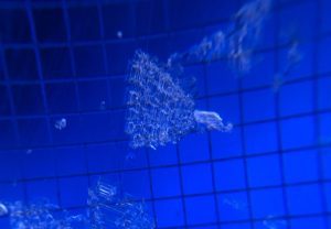
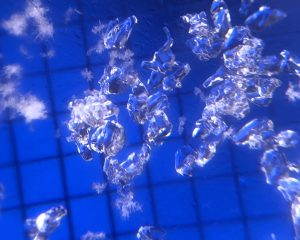
Surface Hoar from Girls Mountain at ~3000′ on 1/13 when it was still at the surface.

Likelihood:
- Almost Certain
- Very Likely
- Likely
- Possible
- Unlikely
Size:
- Historic
- Very Large
- Large
- Small
Trend
- Increasing
- Steady
- Decreasing
Problem 3
Faceted snow at the base of our snowpack has not been reactive for 12 days, on 1/6 one outlier avalanche occurred at mid elevation near Thompson Pass (see avalanche activity section). Prior to this, avalanches haven’t occurred since 12/16 at these deep layers.
A slowly building snowpack and recent benign weather have allowed our snowpack to slowly gain strength. Rounding (strengthening) has been observed at these facets in all three forecast zones, but this process takes a lot of time. At this point triggering an avalanche at this layer is very unlikely. Once significant snowfall returns to our area expect for the potential to affect these deep layers to increase.
Unlikely does not mean impossible, and triggering an avalanche deep in the snowpack would carry significant consequences. The most likely place to affect these layers would be in thin, rocky areas in the Continental zone.
Rounding facets near the base of our snowpack from Cracked Ice at 4000′ on 1/11.

Likelihood:
- Almost Certain
- Very Likely
- Likely
- Possible
- Unlikely
Size:
- Historic
- Very Large
- Large
- Small
Trend
- Increasing
- Steady
- Decreasing
Avalanche Activity
Below is a summary of observed Avalanche activity from the last 7 days. Avalanches that were noted earlier in the season can be viewed by clicking the link below.
If you trigger or observe a natural avalanche consider leaving a public observation.
1/17- Numerous wet loose point release were observed on solar aspects in the Port of Valdez. Most of these originated from rocks were the suns energy permeated into dry snow and caused surface snow to become upside down. No step down slab avalanches were observed.
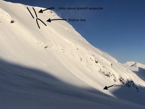
-Small (D1) spin drift avalanches on the lee side of Tones Temple ridge triggered a small slab at the 1/14 BSH layer.
1/13- Numerous natural shallow (D1) soft slab avalanches were observed on all aspects and elevations. These were about 4 inches deep and look to have occurred during peak intensity of the 1/11 snowfall event.
Weather
Check out our updated weather tab! A collection of local weather stations are available for viewing with graphs and tabular data included.
NWS Watches and warnings
NONE
NWS Point forecast for Thompson Pass
Date               Wednesday 01/18/23      Thursday 01/19/23
Time (LT)          06    12    18    00    06    12    18    00    06
Cloud Cover        BK    SC    OV    OV    OV    OV    OV    OV    OV
Cloud Cover (%)    55    45    80    90    95    95    95   100   100
Temperature        10    15    20    16    16    21    24    18    21
Max/Min Temp                   21          14          26          15
Wind Dir            E    SE    NE     E     E    NE     E    SE     E
Wind (mph)          5     2     5    10    12    12    11    11     3
Wind Gust (mph)                            34    26          26
Precip Prob (%)    10     5     5    30    50    70    80    90    80
Precip Type                           S     S     S     S     S     S
12 Hour QPF                  0.00        0.06        0.20        0.46
12 Hour Snow                  0.0         0.0         2.1         7.0
Snow Level (kft)  0.0   0.0   0.0   0.0   0.0   0.6   0.9   1.2   1.3
Click on link below for Thompson Pass weather history graph:

| Date:
01/18 |
24 hr snow | HN24W* | High temp | Low temp | 72 hour SWE* | January snowfall | Seasonal snowfall | Snowpack Depth |
| Valdez | 0 | 0 | 27 | 11 | .21 | 26 | 123 | 45 |
| Thompson pass | 0 | 0 | N/O | N/O | ~.2 | 54 | 248 | 39 |
| 46 mile | 0 | 0 | 11 | -10 | 0 | 24 | ~60** | 36 |
*HN24W- 24 hour Snow water equivalent in inches
*SWE– Snow water equivalent
**46 mile seasonal snowfall total begins December 1st.
Additional Information
Click on the link below for a running summary of the seasons weather history.
Announcements
The avalanche hazard is Moderate above 2000′ and Low below. Human triggered avalanches up to 1 foot deep are possible on the lee side of high elevation ridge lines and lee slopes in wind channeled terrain. Watch for signs of recent wind loading and avoid freshly wind loaded slopes.
Posted by Gareth Brown 01/18 8:00 am.
For a description of current avalanche problems, weather information, season history and more click the (+ full forecast) button. Avalanche forecasts will be issued Wednesday-Sunday.
If you have pictures of recent natural or human triggered avalanches or notice signs of instability such as shooting cracks or collapsing, leave an observation to help improve forecast accuracy.