Haines Avalanche Center
Above 2,500ftHigh
1,500 to 2,500ftHigh
Below 1,500ftHigh
Degrees of Avalanche Danger
Avalanche Problems
Problem 1
The Bottom Line: This zone received around 2 feet of new snowfall in the last 2 days, and SE winds were howling. Temperatures increased by nearly 20 degrees F. There was probably a natural avalanche cycle and these fresh storm snow instabilities (3ft deep or more) will be slowly settling down. Avoid all avalanche terrain today, and be especially mindful to avoid terrain traps where even small slides can pile up deep. Stick to the trees, and avoid any steep openings or gullies. Remember that cornices have grown quite large and will be ready to fall. Stay far back and away from all cornices and snow ledges.
Any surface avalanches within the new snow could step down to one or more Deep Persistent weak layers and cause a very wide and deadly avalanche. Consequences are high.
Give runout zones a wide berth. Natural avalanches are still possible and they could be quite large.

Likelihood:
- Almost Certain
- Very Likely
- Likely
- Possible
- Unlikely
Size:
- Historic
- Very Large
- Large
- Small
Trend
- Increasing
- Steady
- Decreasing
Problem 2
Recent heavy snowfall and strong warming is stressing the remaining persistent weak layers deeper down in the snowpack. The result is an increased likelihood of very large and deadly avalanches that can break super wide across a slope.
When seeking out wind protected zones, remember that wind-protected pockets may be harboring buried surface hoar layers. Protected means preserved.
Buried Surface Hoar Layers (These layers have become less reactive in snowpits, but smaller slides could still step down and trigger them):
- Jan 25th melt freeze crust is about 3-4 feet deep (with recent winds and snow, there is a lot of variability on depth of this widespread layer) sitting on top of it are near surface facets, and buried surface hoar from Feb 1-4.
- January 10th surface hoar is now buried about 4-5 feet deep
Old Melt Layers and Crusts:
- Dec 31 surface hoar layer is present in the Transitional and Pass zones, about 5 ft deep. This layer caused some natural avalanches in early January.
- A buried persistent weak layer about 8+ feet deep (The “Big Warmup” Layer, Formed Nov 17th) is still a concern. Numerous natural avalanches observed 1/27 likely on this layer.
- A wide safety margin is necessary. This setup could produce avalanches that break wider than expected, and are most likely to be triggered from shallow trigger points like rocks or small trees. You could ride the same slope numerous times until that right spot produces a large destructive slide.
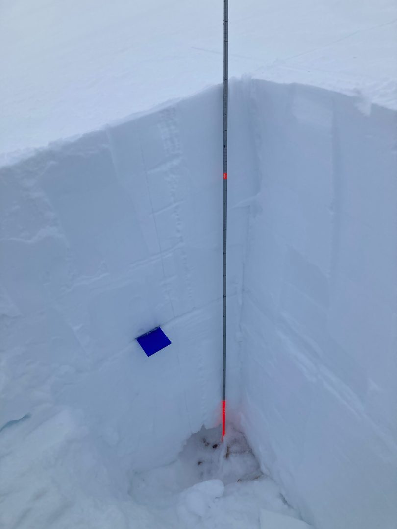
Pit at Old Faithful, 2700’, East aspect on Mar 15 (now has an additional 2ft on top). PST 60/100 End on the Jan 10 buried SH 4-6mm that is rounding down 130 cm

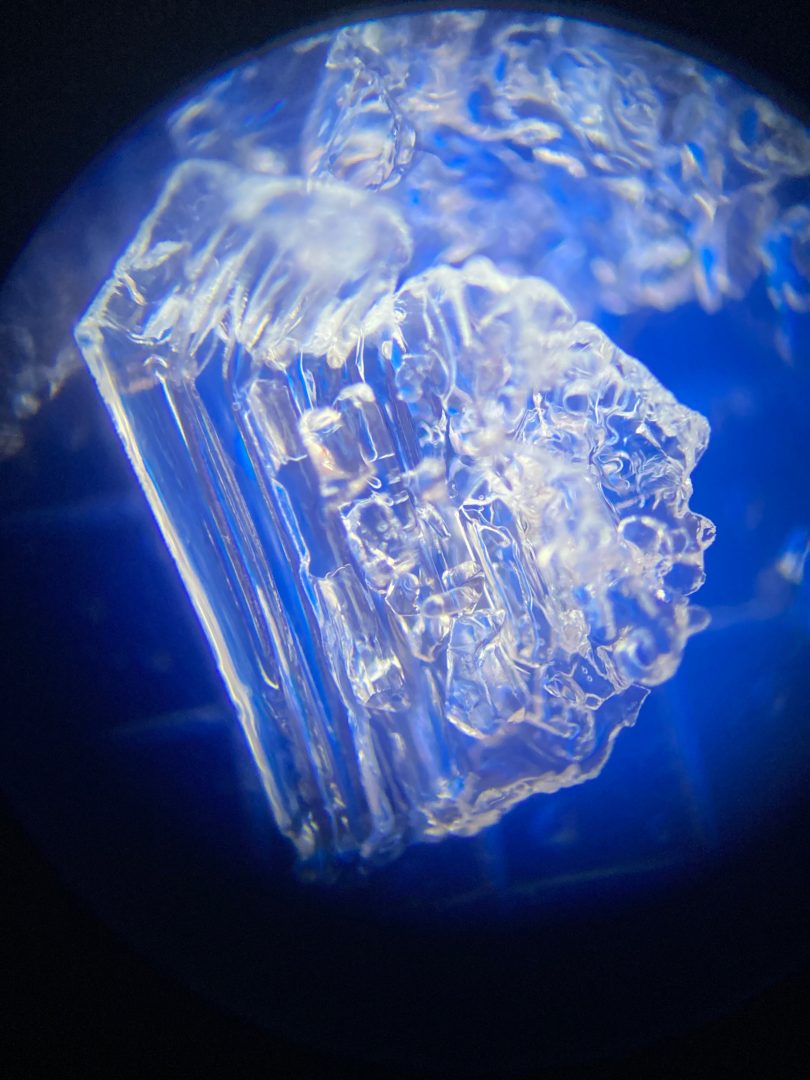
Depth Hoar at the Ground (In thinner areas above 3,000′):
- October snow followed by long cold snaps created depth hoar at the ground in most areas.
- You are most likely to human-trigger this layer from shallow spots around rocks, or trees, or have a surface avalanche step down to the ground on this layer. Any slides that break to the ground are likely to be deadly.
Photos shows 6-9mm advanced depth hoar at the ground down 180cm with ECTP 25 down 80cm on facets below a crust in the Haines Pass Zone at 4,000ft on a NE-aspect.

Likelihood:
- Almost Certain
- Very Likely
- Likely
- Possible
- Unlikely
Size:
- Historic
- Very Large
- Large
- Small
Trend
- Increasing
- Steady
- Decreasing
Problem 3
Snow levels reached up to 1700ft over the last 24 hours. Below that level, there was a lot of rain-on-snow. Wet slabs and large wet-loose avalanches are likely today below 1500ft, especially in open terrain steeper than 32 degrees. This will add to the threat of avalanches today, even down at lower elevations.

Likelihood:
- Almost Certain
- Very Likely
- Likely
- Possible
- Unlikely
Size:
- Historic
- Very Large
- Large
- Small
Trend
- Increasing
- Steady
- Decreasing
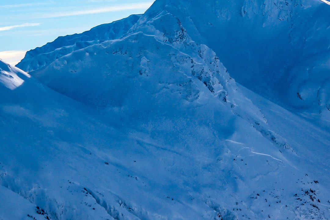
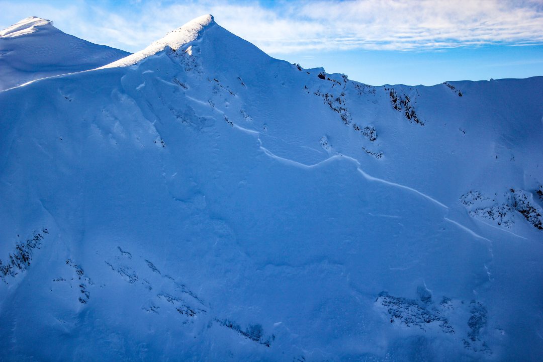
Avalanche Activity
March 7-9: Multiple D2 natural wind slab avalanches in top 45cm, on wind loaded SW, S, SE aspects in the Transitional zone, 3000-4000ft.
March 4-5: Human triggered wind slab D1/D2 at 5-mile creek Chilkat Pass, 2200ft, W aspect
D2-R4 hard slab: Mid-slope propagation, E aspect, in steep wind loaded area, unsupported slope.
D2-R4 New Faithful, W aspect, high alpine
March 2: Small natural soft slabs were observed in steep trees in the Lutak zone. This kind of small to large natural activity is likely widespread in the Lutak zone.
Feb 19-23: 6 different observations of natural avalanches in the transitional zone and in the Chilkat range. The natural D2 slides were on all aspects, a few on lower angle, all running on a mid-snow pack layer, and a majority with widespread propagation.
A larger, D3-R4 natural avalanche was observed near Four Winds on a S, SW aspect, down 60-120cm, it looked like a loose wet slide that maybe stepped down to a lower layer. Widespread propagation.
Feb 9: Glide cracks ~3000-3400′ in the transitional zone on N, NE aspects. Also notable was observation of reloading of bed surfaces on previous slides.
Jan 28: Two D2’s in the Glory Hole. NW-aspect around 3,200′
Jan 25-29th Multiple wide propagating natural slides released.
Weather
Forecast:
Friday we can expect the precipitation to end early on, with moderate SE winds and steady temperatures. We may get another short period of light snowfall Friday night and/or Sunday, but otherwise expect mostly cloudy conditions and decreasing winds, and temperatures cooling off slightly.
Recent Weather Summary:
- March 15-16: 2-4 feet of new snow, strong south winds, and warming temperatures, snow levels reached about 2000ft.
- March 4-7 strong NW / N outflow event with cooling temps.
- March 1st brought a strong and cold storm, with 10-15″ of new snow inland, and 30″+ in the Lutak zone.
- Late Feb 20-Feb 23 a cold high pressure system with moderate to strong N, NW winds
- Feb 19-Feb 20- warmer, solar effect on south aspects, valley fog on the 19th at ~1500-2000 ft.
- Feb 12 freezing levels 1250ft
- Incremental snow (more in Lutak zone) since Feb 5th, periods of moderate S/SE winds
- Feb 1-4 Near surface facets on top of crust from Jan 25 warm-up
- Jan 17-26 brought around 5″ of precip (3-5feet of new snow above 3000ft), strong SE winds, and a noticeable warmup
- Surface Hoar and Near Surface Facet growth Jan 8-10
- A strong front brought 24-30″ of snow above 2000ft on Jan 2nd.
- There was widespread Surface Hoar growth on Dec 31st.
- Complete Season Histories: Transitional Zone Lutak Zone
| Snow Depth | Last 24-hr Snow/SWE | Last 3-days Snow/SWE | Today’s Freezing Level | Today’s Winds | Next 24-hr Snow/SWE | |
| Mount Ripinsky @ 2,500′ | 158″ | 24″ / 2.00 | 42″ / 3.50 | 1500′ | mod, SE | 1″ / 0.10″ |
| Flower Mountain @ 2,500′ | 83″ | 12″ / 1.00 | 24″ / 2.00 | 1500′ | mod, SE | 0″ / 0.00″ |
| Chilkat Pass @ 3,100ft | 54″ | 10″ / 0.85 | 18″ / 1.50 | 1500′ | mod, SE | 0″ / 0.00″ |
Additional Information
WEAR A HELMET! Be careful of rocks and hidden hazards. Be prepared for crevasses when on a glacier.
Are your riding companions trained and practiced in avalanche rescue? Everyone in your group needs to have a beacon, shovel, and probe, and know how to use them. Our mountains have very limited cell coverage, carry an emergency communication device and enough gear to spend the night.

Avalanche Canada’s Daily Process Flow – Utilize this everyday you go out in the mountains.
Announcements
Click the +Full Forecast link below for each zone to read more. If you see any recent natural avalanche activity, or signs of instability please submit an observation.