Haines Avalanche Center
Above 2,500ftConsiderable
1,500 to 2,500ftConsiderable
Below 1,500ftConsiderable
Degrees of Avalanche Danger
Avalanche Problems
Problem 1
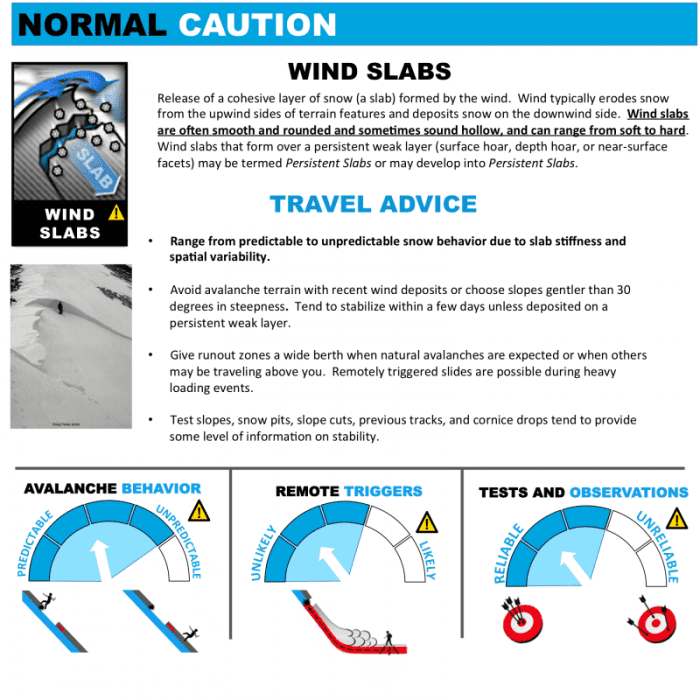
Confidence: High. Distribution: Specific to wind loaded aspects (S-E-W). Sensitivity: Touchy.
Recent NW winds and forecasted northerly flow have drifted new snow into sensitive wind slabs. Human triggers are very likely. Moderate to strong winds transported snow significantly faster than it fell from the sky, resulting in deep deposits on leeward slopes. These fresh wind slabs are sitting over a variety of old snow surfaces including now buried near surface facets, melt-freeze crusts, and sun crusts. Cross loading and top loading adds texture to the snow surface, so keep an eye out of visible loading patterns. Wind slabs often are triggered from shallow areas in the snowpack like rocks, cliffs and vegetation and propagate to deeper areas. Be aware of run-out zones, islands of “safety”, underlying terrain and terrain traps. Avoid wind loaded slopes.

Likelihood:
- Almost Certain
- Very Likely
- Likely
- Possible
- Unlikely
Size:
- Historic
- Very Large
- Large
- Small
Trend
- Increasing
- Steady
- Decreasing
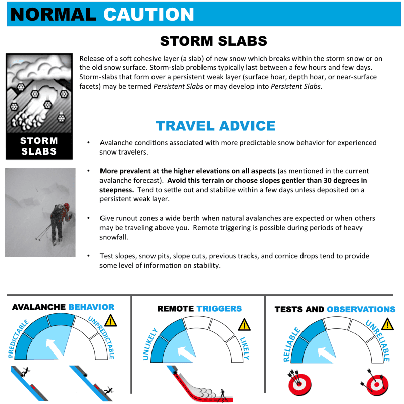
Problem 2
Confidence: High. Distribution: Widespread. Sensitivity: Reactive.
Recent storm snow on all aspects at all elevations will be reactive to human triggers, as it slowly bonds to the old snow surface and settles out. Human triggers are likely within the new snow, while the trend decreases over time. Keep in mind weak near surface facets that are now buried, or hard melt-freeze crusts provide a smooth running surface for the avalanches to occur on. Anticipate releases on slopes greater than 30 degrees and limit exposure by traveling one at a time. Keep in mind that wind drifted snow, or wind slab could be significantly deeper and harder to anticipate (see wind slab problem above).

Likelihood:
- Almost Certain
- Very Likely
- Likely
- Possible
- Unlikely
Size:
- Historic
- Very Large
- Large
- Small
Trend
- Increasing
- Steady
- Decreasing
Avalanche Activity
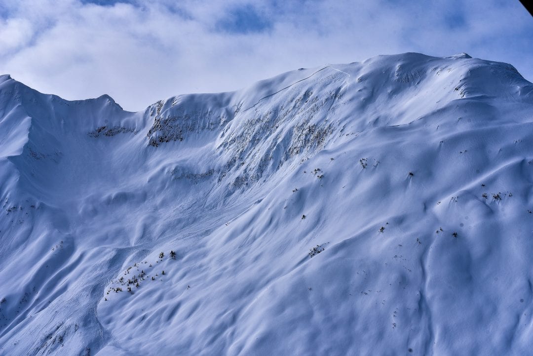
March 22nd – an impressive D3 natural slide in the Transitional Zone, on a steep unsupported S/SE aspect at about 4500ft. Occurred with direct solar radiation on the slope. This is an indication of the wide propagation potential and deep slab nature of our tricky persistent slab problem. South aspects should be considered highly suspect during times of solar radiation. Other aspects will likely also get into the action as temperatures warm up this spring.
Weather
Wednesday temperatures at sea-level were below freezing while overnight alpine temperatures were in the single digits! A cold northerly flow provided clear sunny weather before a winter storm walloped the town-site of Haines in 16-24″ of snowfall. Accumulation was significantly less up the valley’s and near the border around 6-8″. Strong northwest winds followed and the northerly flow will continue into the weekend until Sunday.
| Snow Depth [in] | Last 24-hr Snow/SWE [in] | Last 3-days Snow/SWE [in] | Today’s Freezing Level [ft] | Today’s Winds | Next 24-hr Snow/SWE | |
| Mount Ripinsky @ treeline | 130″+* | 24″ / 2.00* | 24″ / 2.00* | 200′ | mod, SE | 0″ /0.00* |
| Flower Mountain @ treeline | 108 | 5″ / 0.40 | 5″ / 0.50* | 0′ | mod, SE | 0″ /0.00* |
| Chilkat Pass @ 3,100ft | 59″ | 4″ / 0.30 | 0″ / 0.30* | 0′ | mod, SE | 0″ /0.00* |
( *star means meteorological estimate )
—The Mt. Ripinsky weather station is completely buried and no longer reporting.—
Additional Information
Practice like you play. Make sure all your rescue gear it is fully functional and your beacon has full batteries. Make sure 1) everyone in the group has a functioning beacon, shovel and probe 2) knows how to use them and 3) has trained in companion rescue in the last year. Keep your skills fresh. If you head into the hills, watch out for red flag avalanche conditions, natural avalanches, whoomphing or collapsing, and shooting cracks.
Education Video Links:
- AIARE
- How to Practice Avalanche Rescue Snowmobile Edition: https://youtu.be/2ML499MMDfM
- AK Sled Shed Motorized Learning:
- Intro: https://youtu.be/aoagKHfGkxs
- Personal Electronics in Avalanche Terrain: https://youtu.be/2Vz9S0OEyFk
- Snowmobile Macgyver Tool Kit: https://youtu.be/4WBNu_t6Bbk
- Head and Face Protection: https://youtu.be/jIzW89wOyZI
- Pre-season prep: https://youtu.be/zJmrb8cZlR4
- My Transceiver: https://youtu.be/yblaDWP7Jf8
- BCA Avalanche Safety for Snowmobilers
- How to Fix Common Snowmobile Problems in the Field: https://youtu.be/g9fiTxEvuFk
- Sleducation: Avalanche Safety for Snowmobilers: https://youtu.be/EWFOd_9DYb8
- Intro to Avalanche Transceivers for Snowmobilers: https://youtu.be/6ZLSBmsceog
- Avalanche Transceiver Trailhead Test for Snowmobilers: https://youtu.be/rWoXbadFBsY
- Avalanche Transceiver Searching Use Snowmobiles: https://youtu.be/w1ucyI6LMXM
- BCA Avalanche Rescue Series
- Beacon Search 101: https://youtu.be/nnHXLVA2FcE
- Avalanche Probing 101: https://youtu.be/-0_yDN5Drzw
- Avalanche Shoveling 101: https://youtu.be/dGQg9o3vAkM
- Organizing a Backcountry Rescue: https://youtu.be/gywtmukgt8s
- Post Avalanche Patient Care: https://youtu.be/9FyIeUy4wpQ
- Backcountry Evacuation: https://youtu.be/WPF-dciefL8
- Complex Multiple Burials Backup Techniques: https://youtu.be/pB6AfY2KyYo
- National Avalanche Center
- Avalanche Problems Explained: https://youtu.be/DkbnT_9-cHU
- Intro to North American Avalanche Danger Scale: https://youtu.be/r_-KpOu7tbA
Announcements
Click the + Full Forecast link below for each zone to read more. Submit and read local observations below.