Haines Avalanche Center
Above 2,500ftConsiderable
1,500 to 2,500ftModerate
Below 1,500ftModerate
Degrees of Avalanche Danger
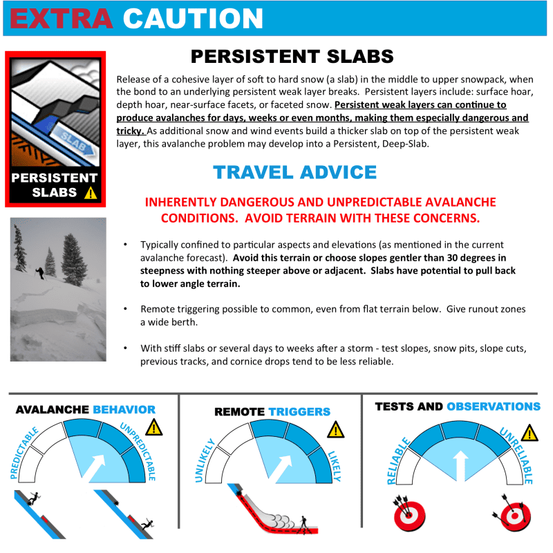
Avalanche Problems
Problem 1
Aspect: All aspects, especially wind loaded terrain
Elevation: Above Treeline
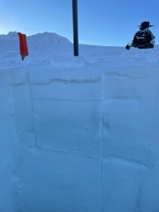
Rain Crust up to 3300′ on Flower Mountain & Propagating test results at 3500′ down 30cm ECTP 13 with a very hard failure down 100cm (Both photos from 2/10/2022)
Bottom Line: There is uncertainty on how deep this problem is lurking. Fresh hard wind slab in the alpine may be waiting for a trigger, especially on high, cold, steep aspects where snow was available for transport. Stronger layers are ultimately sitting over weaker layers as settlement and bonding slowly occurs. In steep or wind loaded areas, you may be able to cause a slide deep enough to bury or kill. Due to the nature of the current persistent problem, snow pit test results and observations can at times be unreliable due to a lack of feedback.
Our snowpack was nuked over the last week: first with heavy snowfall, then strong warming, then more heavy loading. Added up, there was 2.5″ of new SWE (nearly 3 feet of new snow above 3000ft) in this zone. This stressed our previous weak layers and probably caused a natural avalanche cycle. The next storm is likely to produce new instabilities near the surface. Below 3,000ft hard surface conditions exist from warming last week and cooling trend from Thursday.
Travel Advice:
- Think about the consequences of a deep, wide hard slab breaking before you commit to a slope. How can you avoid triggering an avalanche? What is your plan if one is triggered? Always reduce your exposure to these risks as much as possible. Travel one-at-a-time in avalanche terrain, and only group up in safe areas, with a wide safety margin.
- Stick to slopes less steep than 30-degrees while in the alpine. If you choose to venture onto steeper slopes, carefully evaluate them by digging, probing, and testing them.
- Look for shooting cracks, whumphing or collapsing that indicate a stiffer slab over weaker snow.
- Hard wind slabs can break above you, take into consideration extra safety margins
- Probe and feel for slabs underneath you

Likelihood:
- Almost Certain
- Very Likely
- Likely
- Possible
- Unlikely
Size:
- Historic
- Very Large
- Large
- Small
Trend
- Increasing
- Steady
- Decreasing
Avalanche Activity
From 1/29 to 2/1, several reports came in of recent avalanches in the alpine. The common characteristics of these slides were wide propagation, and failing 2-5ft deep at the interface below the wind slabs from last week’s atmospheric river. We have strong reason to suspect these slides occurred on a buried surface hoar layer from 1/20. They happened on all aspects, at elevations from 3000 – 5000ft, and all were in wind sheltered areas below ridges, features, and starting zones. Slide were observed in the Transitional and Lutak zones.
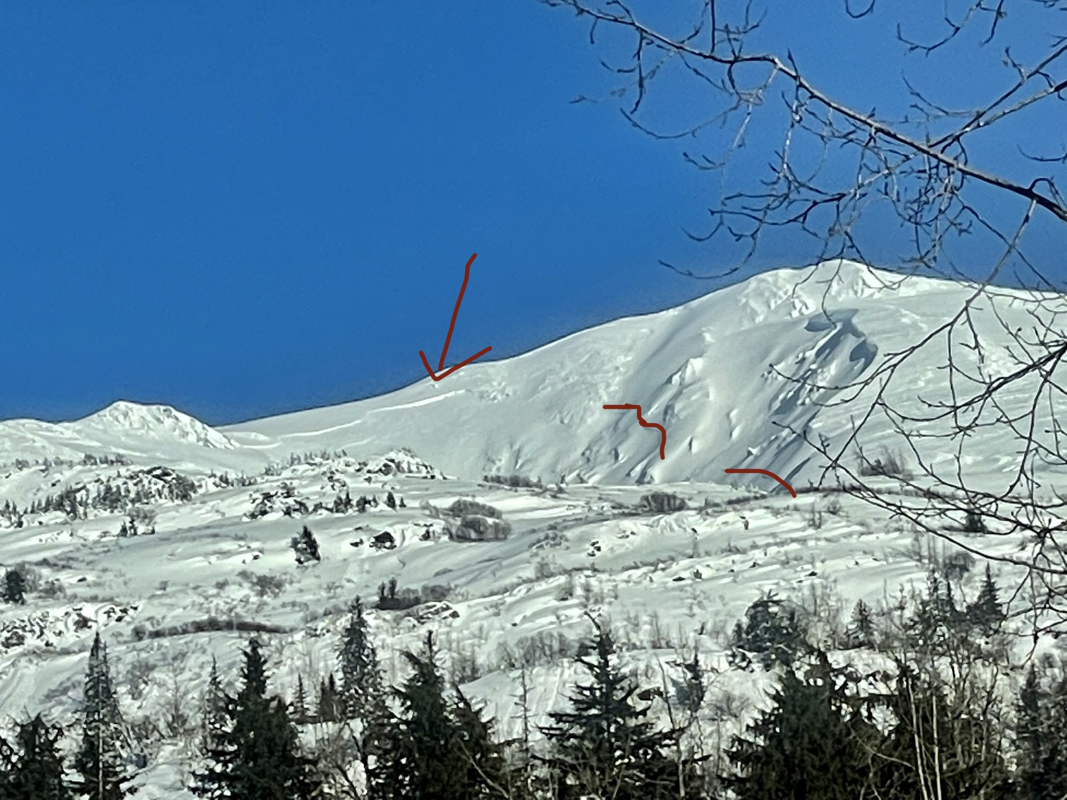
4Winds zone. SW. 4000-5000′
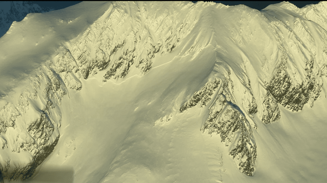
Near Mt. Kraus

The confluence of the Boundary and Saksaia glaciers above Glacier Creek. N. ~4700′
Weather
Forecast:
Overcast skies with snow/rain showers. Moderate S-SE winds decreasing by end of day. More mild/spring like temps with Freezing Levels around 1500
Seasonal Summary:
- Feb 5th-9th brought snow levels near 3,500ft, and 2.5-4″ of SWE with strong south winds.
- Feb 1st-4th brought in 12-24″ of low density powder.
- Jan 27-29 brought 1.5 – 2.4″ of SWE with freezing levels near 1500ft.
- An Atmospheric river hit Jan 21-22. It brought in 2-7″ of SWE (2-5ft of snow above 2500ft, mostly rain below)
- Jan 9th-15th brought 24-48″ of new snow in the alpine, with some light rain up to 3,500ft, followed by heavier rain up to 2000ft.
- Very strong NW winds and arctic temperatures blasted the area the first week of January.
- Jan 1st: New snow (20″ in Lutak, 7″ Transitional zone) buried any preserved surface hoar.
- Moderate NW winds hit exposed slopes Dec 19-20th.
- Surface hoar formed on all aspects and elevations Dec 17-18th.
- December brought in about 2-5 feet of snowfall (highest in Lutak zone), and a few strong NW wind events.
- November brought consistent heavy snowfalls, cold weather, and SE winds.
- October brought heavy snow in the alpine, followed by a few rain/sun crusts.
| Snow Depth [in] | Last 24-hr Snow/SWE [in] | Last 3-days Snow/SWE [in] | Today’s Freezing Level [ft] | Today’s Winds | Next 24-hr Snow/SWE | |
| Mount Ripinsky @ treeline ** | 120″ * | 0″ / 0.00″* | 5″ / 0.40″* | 1000-1800′ | Mod, S | .5″ /1″ * |
| Flower Mountain @ treeline | 73″ | 0″ / 0.00″ | 5″ / 0.40″ | 1000-1700′ | Mod, SE | 2″ / 1 “ |
| Chilkat Pass @ 3,100ft | 29″ | 1″ / 0.10″ | 3″ / 0.20″ | 1000-1500′ | Mod, S | 2″ / 1″* |
( *star means meteorological estimate )
** The Ripinsky weather station is in need of repair, and will likely be down until Summer.
Additional Information
Safe backcountry travel requires training and experience. You control your own risk by choosing where, when and how you travel. Ride rescue ready. Be prepared for an emergency. Prevent hypothermia. Carry bear spray. Winter is a high consequence environment.
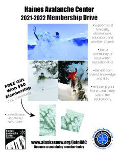
Become a sustaining Haines Avalanche Center Member by clicking the poster or visiting dev.alaskasnow.org/joinHAC. Support local forecasts, observations, education and weather stations. Join a community of winter recreationalists. Benefit from collective knowledge and skills. Help keep your friends and family safe in the backcountry. Get a free limited edition mountain buff, or neck gaiter with a $50 membership (first 20 members!).
Practice like you play. Make sure all your rescue gear is fully functional and your beacon has NEW batteries. Make sure 1) everyone in the group has a functioning beacon, shovel and probe 2) knows how to use them and 3) has trained in companion rescue in the last year. Keep your skills fresh. If you head into the hills, watch out for red flag avalanche conditions, natural avalanches, whoomphing or collapsing, and shooting cracks.
Education Video Links:
- AIARE
- How to Practice Avalanche Rescue Snowmobile Edition: https://youtu.be/2ML499MMDfM
- AK Sled Shed Motorized Learning:
- Intro: https://youtu.be/aoagKHfGkxs
- Personal Electronics in Avalanche Terrain: https://youtu.be/2Vz9S0OEyFk
- Snowmobile Macgyver Tool Kit: https://youtu.be/4WBNu_t6Bbk
- Head and Face Protection: https://youtu.be/jIzW89wOyZI
- Pre-season prep: https://youtu.be/zJmrb8cZlR4
- My Transceiver: https://youtu.be/yblaDWP7Jf8
- BCA Avalanche Safety for Snowmobilers
- How to Fix Common Snowmobile Problems in the Field: https://youtu.be/g9fiTxEvuFk
- Sleducation: Avalanche Safety for Snowmobilers: https://youtu.be/EWFOd_9DYb8
- Intro to Avalanche Transceivers for Snowmobilers: https://youtu.be/6ZLSBmsceog
- Avalanche Transceiver Trailhead Test for Snowmobilers: https://youtu.be/rWoXbadFBsY
- Avalanche Transceiver Searching Use Snowmobiles: https://youtu.be/w1ucyI6LMXM
- BCA Avalanche Rescue Series
- Beacon Search 101: https://youtu.be/nnHXLVA2FcE
- Avalanche Probing 101: https://youtu.be/-0_yDN5Drzw
- Avalanche Shoveling 101: https://youtu.be/dGQg9o3vAkM
- Organizing a Backcountry Rescue: https://youtu.be/gywtmukgt8s
- Post Avalanche Patient Care: https://youtu.be/9FyIeUy4wpQ
- Backcountry Evacuation: https://youtu.be/WPF-dciefL8
- Complex Multiple Burials Backup Techniques: https://youtu.be/pB6AfY2KyYo
- National Avalanche Center
- Avalanche Problems Explained: https://youtu.be/DkbnT_9-cHU
- Intro to North American Avalanche Danger Scale: https://youtu.be/r_-KpOu7tbA
Announcements
Click the +Full Forecast button below to read the details. Please submit your observations if you head out!