Haines Avalanche Center
Above 2,500ftConsiderable
1,500 to 2,500ftModerate
Below 1,500ftModerate
The Avy Rose shows the forecasted danger by elevation and aspect. It adds more detail about where you are likely to find the dangers mentioned in the forecast. The inner circle shows upper elevations (mountain top), the second circle is middle elevations, and the outer circle represents lower elevations. Think of the Rose as a birds-eye view of a mountain, looking down from above. The rose allows our forecasters to visually show you which parts of the mountain they are most concerned about.
Degrees of Avalanche Danger
Avalanche Problems
Problem 1
This zone received about 8″ of new snow this week, and about 6″ last week. South winds were blowing in the alpine during last week’s storms, which caused significant wind loading on W-NW-N-NE-E aspects. This week’s snow fell in light winds, but will add additional load to previous weak layers. You may find loose-snow (fast, large sluff) dangers in steeper terrain, and soft slab dangers in more wind-affected areas.
There is also significant Step Down potential right now. Any surface avalanches could easily step down to deeper weak layers that then trigger a wide, deadly avalanche. See the Persistent Slab problem below.

Likelihood:
- Almost Certain
- Very Likely
- Likely
- Possible
- Unlikely
Size:
- Historic
- Very Large
- Large
- Small
Trend
- Increasing
- Steady
- Decreasing
Problem 2
Aspect: All aspects and below terrain features
Elevation: Mainly Treeline and above
Observations from Ripinsky yesterday found collapsing and cracking on old wind slabs in the midpack. These slabs were failing on softer layers (facets) 1-3ft deep, that formed over the last two weeks. Snowpit results found clean, active shears 1 meter deep, which means potential for propagation and a lack of friction on the layer.
As if that isn’t enough to give you pause, we have also found significant weak facets at the bottom of the alpine snowpack in both zones, and the lingering October Rain Crust with weak layers above and below it. It is possible that any surface avalanches could step down to the deeper rain crust, or even the ground in alpine areas.
- One of the best ways to reduce your exposure to deep persistent weak layers would be to stick to areas of deeper snowpack (>1m deep). But be wary of hidden rocks that can act as trigger points, and thin areas around the margins of a slab.
- Look and listen for deep whumping! Report any natural avalanche activity on these deeper layers!

Likelihood:
- Almost Certain
- Very Likely
- Likely
- Possible
- Unlikely
Size:
- Historic
- Very Large
- Large
- Small
Trend
- Increasing
- Steady
- Decreasing
Weather
We’ve had about 20″ of low-density new snow this week in the Lutak zone, and around 8″ in the Transitional zone.
Last week, it snowed 6-14″. Winds switched from SE to NW and increased into typical northerly outflow as temperature plummeted into the single digits.
October brought heavy snow in the alpine, followed by a few rain/sun crusts, followed by regular heavy snowfalls in November.
| Snow Depth [in] | Last 24-hr Snow/SWE [in] | Last 3-days Snow/SWE [in] | Today’s Freezing Level [ft] | Today’s Winds | Next 24-hr Snow/SWE | |
| Mount Ripinsky @ treeline ** | 67″ | 8″ / 0.50* | 18″ / 1.15* | 0′ | Light, NW | 7″ / 0.40* |
| Flower Mountain @ treeline | 50″ * | 2″ / 0.10 | 8″ / 0.30 | 0′ | Light, NW | 5″ / 0.30* |
| Chilkat Pass @ 3,100ft | 29″ | 0″ / 0.00 | 3″ / 0.15 | 0′ | Light, NW | 3″ / 0.20* |
( *star means meteorological estimate )
** The Ripinsky weather station is in need of repair, and will likely be down until Summer.
Additional Information
Beware of deep treewells which can trap a person. It’s deep out there. Temperatures and wind chill are cold. Be prepared to prevent hypothermia.
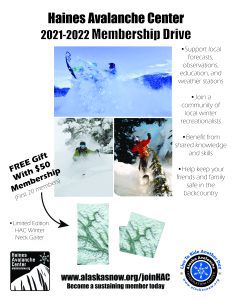
Become a sustaining Haines Avalanche Center Member by clicking the poster or visiting dev.alaskasnow.org/joinHAC. Support local forecasts, observations, education and weather stations. Join a community of winter recreationalists. Benefit from collective knowledge and skills. Help keep your friends and family safe in the backcountry. Get a free limited edition mountain buff, or neck gaiter with a $50 membership (first 20 members!).
Practice like you play. Make sure all your rescue gear is fully functional and your beacon has NEW batteries. Make sure 1) everyone in the group has a functioning beacon, shovel and probe 2) knows how to use them and 3) has trained in companion rescue in the last year. Keep your skills fresh. If you head into the hills, watch out for red flag avalanche conditions, natural avalanches, whoomphing or collapsing, and shooting cracks.
Education Video Links:
- AIARE
- How to Practice Avalanche Rescue Snowmobile Edition: https://youtu.be/2ML499MMDfM
- AK Sled Shed Motorized Learning:
- Intro: https://youtu.be/aoagKHfGkxs
- Personal Electronics in Avalanche Terrain: https://youtu.be/2Vz9S0OEyFk
- Snowmobile Macgyver Tool Kit: https://youtu.be/4WBNu_t6Bbk
- Head and Face Protection: https://youtu.be/jIzW89wOyZI
- Pre-season prep: https://youtu.be/zJmrb8cZlR4
- My Transceiver: https://youtu.be/yblaDWP7Jf8
- BCA Avalanche Safety for Snowmobilers
- How to Fix Common Snowmobile Problems in the Field: https://youtu.be/g9fiTxEvuFk
- Sleducation: Avalanche Safety for Snowmobilers: https://youtu.be/EWFOd_9DYb8
- Intro to Avalanche Transceivers for Snowmobilers: https://youtu.be/6ZLSBmsceog
- Avalanche Transceiver Trailhead Test for Snowmobilers: https://youtu.be/rWoXbadFBsY
- Avalanche Transceiver Searching Use Snowmobiles: https://youtu.be/w1ucyI6LMXM
- BCA Avalanche Rescue Series
- Beacon Search 101: https://youtu.be/nnHXLVA2FcE
- Avalanche Probing 101: https://youtu.be/-0_yDN5Drzw
- Avalanche Shoveling 101: https://youtu.be/dGQg9o3vAkM
- Organizing a Backcountry Rescue: https://youtu.be/gywtmukgt8s
- Post Avalanche Patient Care: https://youtu.be/9FyIeUy4wpQ
- Backcountry Evacuation: https://youtu.be/WPF-dciefL8
- Complex Multiple Burials Backup Techniques: https://youtu.be/pB6AfY2KyYo
- National Avalanche Center
- Avalanche Problems Explained: https://youtu.be/DkbnT_9-cHU
- Intro to North American Avalanche Danger Scale: https://youtu.be/r_-KpOu7tbA
Announcements
Thursday, Friday, Saturday and Sunday forecasts have begun. Click the –Full Forecast– button below for more details. We need your observations!