Haines Avalanche Center
Above 2,500ftConsiderable
1,500 to 2,500ftConsiderable
Below 1,500ftModerate
Degrees of Avalanche Danger
Avalanche Problems
Problem 1
Aspect: W-NW-N-NE-E
Elevation: Near and Above Treeline
Bottom Line: Strong southerly winds January 9th and 10th combined with the 16+” of new snowfall precipitation during the same storm caused significant wind loading on leeward slopes. These leeward slopes greater than 30 degrees should be treated as suspect. Listen for collapsing and look for cracks as sure signs of instability. The upside-down storm system that occurred likely did not bond this new snow well with the existing snowpack.
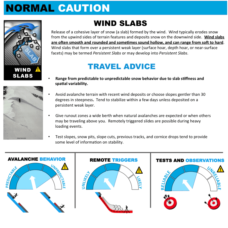

Likelihood:
- Almost Certain
- Very Likely
- Likely
- Possible
- Unlikely
Size:
- Historic
- Very Large
- Large
- Small
Trend
- Increasing
- Steady
- Decreasing
Problem 2
Aspect: all aspects
Elevation: Treeline and below
Bottom Line: Earlier this week we had around 16″+ of new upside-down snow in this zone, followed by a major warm up and more rain-on-snow below treeline. You are likely to encounter wet surface snow below treeline today, and human triggering of heavy wet sluffs and slabs will be likely in terrain steeper than 30 degrees.
Travel Advice: Conditions are saturated and isothermal at lower elevations. Expect the new snow to slide around, or to run from paths above. You should avoid steep terrain and run-outs. Especially watch out for terrain traps where even small slides could pile up quite deep.
See Storm Snow and Persistent Slab problem for above treeline travel advice.

Likelihood:
- Almost Certain
- Very Likely
- Likely
- Possible
- Unlikely
Size:
- Historic
- Very Large
- Large
- Small
Trend
- Increasing
- Steady
- Decreasing
Problem 3
Aspect: Mainly on wind-protected and wind loaded slopes, most likely beneath terrain features on S, SE, and E aspects
Elevation: All elevations, mainly at and above treeline.
Travel advice: Consider any possible slopes harboring buried surface hoar, or other weak snow as guilty until proven innocent. Always use safe travel techniques such as only exposing one person at a time both on the way up and down. Identify and avoid thin areas where weak layers are more likely to trigger a slide from. Group up in safe zones that are out of harms way. Have good communication, including radios and a set plan in case of an emergency. Be practiced at companion rescue..
- Facets formed on the surface at the end of the arctic outflow event (around Jan 7) from high daily temperature swings.
- Surface hoar from Dec 18th may have been preserved in wind-protected areas. It is now buried by about a foot of snow.
- Recent observations from Old Faithful found a thin crust with weak snow down 60-70cm near 3,200′ and below
- This bathtub ring effect, from lower-elevations to mid-elevation, where freezing levels are more likely to cause crusts and weak layers – should be carefully evaluated.
- Weaker snow (buried facets) forming between wind slabs in the top of the pack
It is still possible that any surface avalanches could step down to deeper weak layers, the October rain crust, or even the ground in alpine areas.
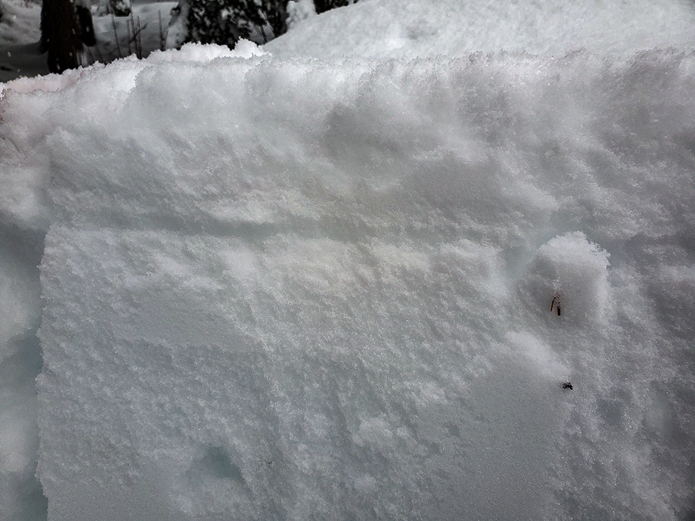
Buried surface hoar layer (thin grey line) in an opening below treeline in the Transitional zone. This layer is now about 1-3ft deep. It exists in isolated wind protected areas.

Likelihood:
- Almost Certain
- Very Likely
- Likely
- Possible
- Unlikely
Size:
- Historic
- Very Large
- Large
- Small
Trend
- Increasing
- Steady
- Decreasing
Avalanche Activity
01/14-15/2022 – Numerous Wet Loose small avalanches reported along Haines Hwy
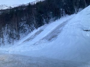
01/15/2022 – An observation from Four Winds Mountain reported a collapse and a remote trigger of an approximately 200′ wide avalanche at 3,000′ on a northern aspect. It was estimated to run a couple hundred feet but low visibility kept observations to a minimum.
Weather
Forecast:
An area of low pressure will track northward towards the southern
panhandle, then eastward towards Canada. This low is expected to
bring rain to the area but the best chance for rain is in the
south. Rain amounts will be greatest in the south where a quarter
to half inch of rain is expected, lighter amounts expected for the
central and northern regions. Warmer temps keep snow out of the
forecast for most of the area. That being said, some light snow,
up to 1 to 2 inches, is possible in the higher elevations of the
northern Lynn Canal area.

As the low tracks away from SE AK and high pressure begins to
build Sunday, the rain and snow chances will decrease beginning
Sunday afternoon. And will continue to decrease into Sunday
night. This high pressure will bring colder temps back to the area.
Seasonal Summary:
- A strong storm brought 16-36″ of new snow Jan 9th-11th, finishing with some light rain up to 3,500ft.
- Very strong NW winds and arctic temperatures blasted the area the first week of January
- Jan 1st: New snow (20″ in Lutak, 7″ Transitional zone) buried any preserved surface hoar.
- Moderate NW winds hit exposed slopes Dec 19-20th
- Surface hoar formed on all aspects and elevations Dec 17-18th
- December brought in about 2-5 feet of snowfall (highest in Lutak zone), and a few strong NW wind events
- November brought consistent heavy snowfalls, cold weather, and SE winds
- October brought heavy snow in the alpine, followed by a few rain/sun crusts
| Snow Depth [in] | Last 24-hr Snow/SWE [in] | Last 3-days Snow/SWE [in] | Today’s Freezing Level [ft] | Today’s Winds | Next 24-hr Snow/SWE | |
| Mount Ripinsky @ treeline ** | 100″* | 0″ / 0.0* | 10″ / 1.88* | 1400′ | Light, S-W | 2″ / 0.19* |
| Flower Mountain @ treeline | 61″ | 0″ / 0.00 | 8″ / 0.60 | 1400′ | Light, S-W | 2″ / 0.19* |
| Chilkat Pass @ 3,100ft | 19.5″ | 0″ / 0.00 | 2″ / 0.20 | 1400′ | Light, S | 1″ / 0.10* |
( *star means meteorological estimate )
** The Ripinsky weather station is in need of repair, and will likely be down until Summer.
Additional Information
Ride rescue ready. Be prepared for an emergency. Prevent hypothermia. Carry bear spray. Winter is a high consequence environment.
Become a sustaining Haines Avalanche Center Member by clicking the poster or visiting dev.alaskasnow.org/joinHAC. Support local forecasts, observations, education and weather stations. Join a community of winter recreationalists. Benefit from collective knowledge and skills. Help keep your friends and family safe in the backcountry. Get a free limited edition mountain buff, or neck gaiter with a $50 membership (first 20 members!).
Practice like you play. Make sure all your rescue gear is fully functional and your beacon has NEW batteries. Make sure 1) everyone in the group has a functioning beacon, shovel and probe 2) knows how to use them and 3) has trained in companion rescue in the last year. Keep your skills fresh. If you head into the hills, watch out for red flag avalanche conditions, natural avalanches, whoomphing or collapsing, and shooting cracks.
Education Video Links:
- AIARE
- How to Practice Avalanche Rescue Snowmobile Edition: https://youtu.be/2ML499MMDfM
- AK Sled Shed Motorized Learning:
- Intro: https://youtu.be/aoagKHfGkxs
- Personal Electronics in Avalanche Terrain: https://youtu.be/2Vz9S0OEyFk
- Snowmobile Macgyver Tool Kit: https://youtu.be/4WBNu_t6Bbk
- Head and Face Protection: https://youtu.be/jIzW89wOyZI
- Pre-season prep: https://youtu.be/zJmrb8cZlR4
- My Transceiver: https://youtu.be/yblaDWP7Jf8
- BCA Avalanche Safety for Snowmobilers
- How to Fix Common Snowmobile Problems in the Field: https://youtu.be/g9fiTxEvuFk
- Sleducation: Avalanche Safety for Snowmobilers: https://youtu.be/EWFOd_9DYb8
- Intro to Avalanche Transceivers for Snowmobilers: https://youtu.be/6ZLSBmsceog
- Avalanche Transceiver Trailhead Test for Snowmobilers: https://youtu.be/rWoXbadFBsY
- Avalanche Transceiver Searching Use Snowmobiles: https://youtu.be/w1ucyI6LMXM
- BCA Avalanche Rescue Series
- Beacon Search 101: https://youtu.be/nnHXLVA2FcE
- Avalanche Probing 101: https://youtu.be/-0_yDN5Drzw
- Avalanche Shoveling 101: https://youtu.be/dGQg9o3vAkM
- Organizing a Backcountry Rescue: https://youtu.be/gywtmukgt8s
- Post Avalanche Patient Care: https://youtu.be/9FyIeUy4wpQ
- Backcountry Evacuation: https://youtu.be/WPF-dciefL8
- Complex Multiple Burials Backup Techniques: https://youtu.be/pB6AfY2KyYo
- National Avalanche Center
- Avalanche Problems Explained: https://youtu.be/DkbnT_9-cHU
- Intro to North American Avalanche Danger Scale: https://youtu.be/r_-KpOu7tbA
Announcements
Bottom Line: Temperatures are starting to return to below freezing but vigilance is key. SE winds blew hard earlier this week in the alpine, while 16+” of new upside-down snow fell. New wind slabs have built up in any wind loaded areas in the alpine, and will be sitting on weak snow that fell Sunday. Avoid these heavily wind loaded areas. Multiple weak layers in the snowpack exist, avoid shallow areas where it is easier to trigger these layers. Human-triggered avalanches in the alpine will be likely within the new snow, likely failing on the new/old snow interface.