Valdez
Above 3,000ftModerate
1,500 to 3,000ftModerate
Below 1,500ftLow
Degrees of Avalanche Danger
Avalanche Problems
Problem 1
There is abundant loose snow available for transport. Northeast winds began to blow 20-30 mph late afternoon at Thompson Pass, and continued through the night. Areas just north of the pass have remained mostly calm. Human triggered avalanches will be possible on lee aspects (SE-NW) where wind is present. Signs of windslab include, a hollow drum like feel, shooting cracks and pillowed snow surfaces. Watch for changing conditions and adjust your plans accordingly if windslabs begin to form.

Likelihood:
- Almost Certain
- Very Likely
- Likely
- Possible
- Unlikely
Size:
- Historic
- Very Large
- Large
- Small
Trend
- Increasing
- Steady
- Decreasing
Avalanche Activity
12/3- Numerous natural avalanches were observed north of Thompson Pass with many avalanches failing at the ground. Observations were not made south of Thompson Pass.
Avalanches observed from 46 mile towards Thompson Pass:
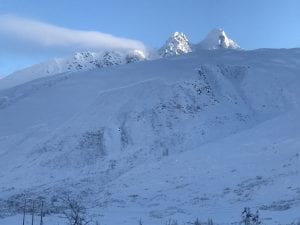
Three Pigs: Nearly every path on the SE face ran with debris deposits stopping in the top 1/3 of aprons, thick alders prevented slides from running full path. These were mostly D3 avalanches.
40.5 Mile Peak: Many paths running similar to Three Pigs, with one running full path to the Tsaina river. Mainly W-NW aspects, D3’s
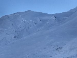
Max High (Peak on the southern extent of Hippie Ridge) had a D3 avalanche with a crown near 5500′,SW aspect.
Upper Catchers Mitt bowl E aspect, slid R4-D3 ,triggering further avalanches lower down.
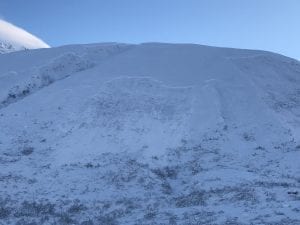
The main activity noted, was on the buttresses on the east side of the pass, from Cracked Ice through North Odessey Gully. Every buttress had significant avalanche activity originating ~4000-5000′. Many of these failed at the ground, north – northwest aspect. Pictures below.
School Bus and North Odyssey Gully both ran with debris in the runouts.
Many other large to very large natural avalanches occurred.
12/2- DOT reported a natural D2.5-3 avalanche that hit the Lowe river at Snowslide Gulch.
11/30- Natural avalanche observed on 40.5 mile peak just to the South of the Shovel. West aspect, ~4500′, crown ~200′ wide, poor light prevented further observation. SS-N-R1-D2-U.
11/29: Natural avalanche observed on Billy Mitchell Cry babys shoulder, similar elevation as 11/16 slide but originated a couple hundred meters further west. Released from ~4000′ with a crown length of ~ 200 meters, North aspect, ~ 37°, failed at the ground. HS-N-R2-D2.5-G
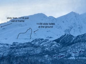
11/16: Natural avalanche observed on Billy Mitchell “Cry babys shoulder”. Released from~3500′ with a crown length of ~200 meters, North aspect. This slide was triggered by recent NE wind cross loading the slope. SS-N-R2-D2-U
11/15: Natural avalanche observed in Loveland Basin on a South aspect, down the ridge from Tones Temple. This slide was triggered by recent NE wind loading and failed at the ground. SS-N-R1-D2-G
Weather
The Thompson Pass Mountain Forecast covers the mountains (above
1000 ft) surrounding Keystone Canyon through Thompson Pass to
Worthington Glacier.

This forecast is for use in snow safety activities and emergency
management.

                   Today        Tonight

Temp at 1000`      30 F         22 F

Temp at 3000`      24-32 F      15-27 F

Chance of precip   0%           40%

Precip amount
(above 1000 FT)    0.00 in      0.04 in

Snow amount
(above 1000 FT)    0 in         trace

Snow level         sea level    sea level

Wind 3000` ridges  NE 20-33 mph  NE 25-36 mph

Remarks...Blowing snow through the pass Monday morning.
| Date: 12/12 | 24 hr snow (inches) | HN24W (snow water equivalent inches) | High Temp (F) | Low Temp (F) | Weekly SWE Inches (Monday-Sunday) | December snowfall | Season snowfall | HS (snowpack depth inches) |
| Valdez | 0 | 0 | 26 | 10 | 1.66 | 14 | 58 | 29 |
| Thompson Pass | 0 | 0 | 16 | -8 | 1.22 | 58 | 176 | 50 |
| 46 Mile | 0 | 0 | 2 | -14 | 1.24 | 23 | 52 | 22 |
Thompson Pass weather history 20/21. Click on links above the images to see full size view
Additional Information
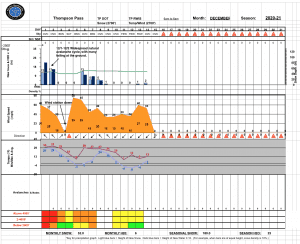
12/8-12/12- Clear cold and calm was the theme during this period. With this, surface hoar has begun to form below 3000′. On 12/12 surface hoar was found to exist up to 1.5 cm in length on flat benches. On slopes the size was 2-4 mm. SH has not been observed in high elevation start zones. If conditions remain calm before the next snowfall this will form a sensitive layer in our snowpack in our low and mid elevation bands.

12/5-12/7- Thompson Pass received 23 inches of snow with 2.23″ of SWE. Temperatures and freezing line rose mid storm bringing rain to the coast.
NE winds began 12/4 and have redistributed the storm snow onto lee aspects. This wind event has not been widespread and appears to be concentrated to areas in close proximity to Thompson Pass.
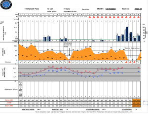
November was mostly dominated by clear, cold and windy weather. On 11/25 a major wx pattern shift occurred which produced 8 days of consecutive storms that delivered 10 inches of water and 90″ of snow to Thompson Pass. This storm fell on a thin snowpack with poor structure near the ground. On 12/1-12/2 a widespread natural avalanche cycle occurred with many avalanches failing at the ground. This event was caused by 4.6″ of SWE on Thompson Pass in a 72 hour period along with rising temperatures bringing the freezing line up to 3000′.
Announcements
The avalanche hazard is Moderate at mid and upper elevations. Human triggered avalanches up to 1′ deep are possible in terrain steeper than 32° that has seen recent wind loading. In areas unaffected by wind the hazard is lower. The latest storm ending 12/8 has deposited up to 2 feet of new snow. This may be redistributed into wind slabs in isolated areas where wind is present. Watch for signs of wind slab, these include stiff snow over soft, shooting cracks and snow that has a hollow drum like feel.. Avoid cross loaded gullies and areas that are receiving active wind loading.
For more information click the (+full forecast) button below.
Your observations are valuable! If you have been out recreating in the mountains, please leave an observation.