Valdez
Above 4,000ftConsiderable
2,000 to 4,000ftConsiderable
Below 2,000ftConsiderable
Degrees of Avalanche Danger
Avalanche Problems
Problem 1
Continued moderate snowfall have been steadily building storm slabs since 11/25. Our thin “weak” snowpack will slowly adjust to this added weight. Natural and human triggered storm slab avalanches will be likely on 11/29.

Likelihood:
- Almost Certain
- Very Likely
- Likely
- Possible
- Unlikely
Size:
- Historic
- Very Large
- Large
- Small
Trend
- Increasing
- Steady
- Decreasing
Problem 2
Winds have been blowing from multiple directions since the last round of storms began 11/25. With abundant dry snow available for transport, and changing wind direction expect wind slabs to have formed on a variety of aspects. Avoid slopes that are actively, or have recently been loaded by wind. Signs of recently loaded slopes include: new snow that gets rapidly deeper over a short distance, like over a ridge or pass. Pillowed snow surfaces, shooting cracks and freshly formed cornices.
Many Cornices are in their infancy stages of forming at this point in the season. While traveling on or below cornices is always dangerous and never recommended. They can be especially dangerous early season when they may be made primarily of freshly drifted snow that almost surely can’t support the weight of a person or snowmachine.
The Thompson Pass RWIS wind station has been down for more than 48 hours, and the FAA camera wind station has been reporting suspect data. With limited field observations during this last round of storms and the TP weather station not recording. There is a lot of uncertainty with this avalanche problem and its distribution.

Likelihood:
- Almost Certain
- Very Likely
- Likely
- Possible
- Unlikely
Size:
- Historic
- Very Large
- Large
- Small
Trend
- Increasing
- Steady
- Decreasing
Avalanche Activity
11/15: Natural avalanche observed in Loveland Basin on a South aspect, down the ridge from Tones Temple. This slide was triggered by recent NE wind loading and failed at the ground. SS-N-R1-D2-G
11/16: Natural avalanche observed on Billy Mitchell “Cry babys shoulder”. Released from~3500′ with a crown length of ~200 meters, North aspect. This slide was triggered by recent NE wind cross loading the slope. SS-N-R2-D2-U
Weather
11/29- Accumulating snowfall is forecasted to continue on Thompson Pass through Sunday, before a brief break on Monday. Warm air is forecasted to move in on Tuesday 12/1 along with another more powerful storm. This storm will likely switch precipitation from snow to rain up to 2500′. Updates to freezing line with this storm will happen as the event gets closer…
The Thompson Pass Mountain Forecast covers the mountains (above
1000 ft) surrounding Keystone Canyon through Thompson Pass to
Worthington Glacier.

This forecast is for use in snow safety activities and emergency
management.

                   Today        Tonight

Temp at 1000`      32 F         23 F

Temp at 3000`      27 F         25 F

Chance of precip   100%         90%

Precip amount
(above 1000 FT)    0.48 in      0.31 in

Snow amount
(above 1000 FT)    1-5 in       3-5 in

Snow level         400 ft       sea level

Wind 3000` ridges  SE 0-15 mph  E 10-20 mph

Remarks...Snow ongoing through the day, continuing into tonight.
Warming temperatures, rising snow levels, rain, snow and heavy
precipitation expected starting Monday afternoon.
| Date: 11/28 | 24 hr snow (inches) | HN24W (snow water equivalent inches) | High Temp (F) | Low Temp (F) | Weekly SWE Inches (Monday-Sunday) | November snowfall | Season snowfall | HS (snowpack depth inches) |
| Valdez | 3 | .15 | 33 | 26 | 1.79 | 41 | 41 | 28 |
| Thompson Pass | N/O | N/O | 24 | 19 | ~4.4 | ~65 | ~100 | ~26 |
| 46 Mile | 6 | .6 | 26 | 22 | 1.6 | 21 | 21 | 18 |
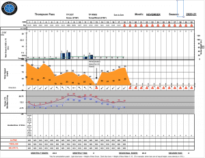
Thompson Pass weather history 20/21. Click on links below the images to see full size view
Announcements
The avalanche hazard is Considerable at all elevations. A series of winter storms beginning 11/25 has deposited more than 3 feet of snow on Thompson Pass. This snow has been deposited on a thin/weak snowpack that needs time to adjust. Human triggered avalanches are likely and natural avalanches are possible. Conservative terrain choices will be critical if traveling in the mountains today. Avoid avalanche paths and terrain traps today. Hazard will be increasing with continued heavy snowfall through Sunday.
For more information click the (+full forecast) button below.
Your observations are valuable! If you have been out recreating in the mountains leave an observation.