Haines Avalanche Center
Above 2,500ftExtreme
1,500 to 2,500ftHigh
Below 1,500ftHigh
Degrees of Avalanche Danger
Avalanche Problems
Problem 1
Given the data in the weather section (below), it should be clear that we are in a major loading event, as precipitation adds stress to layers in the snowpack. Storm slabs will be 60-100cm deep (up to 200cm in some areas), and under a state of constant settlement, adjustment, and avalanching in steep areas. Further heavy precip, rain-on-snow, and further warming will only increase the size of natural avalanches, which are certain to be occurring. Some avalanches could be quite large with this storm. For reference, if we receive as much precip. as expected, that would likely be a 75-100 year storm, as per the National Weather Service. It is not out of the question to see 75-100 year avalanches as well. Avoid all avalanche terrain and lower runout zones!

Likelihood:
- Almost Certain
- Very Likely
- Likely
- Possible
- Unlikely
Size:
- Historic
- Very Large
- Large
- Small
Trend
- Increasing
- Steady
- Decreasing
Problem 2
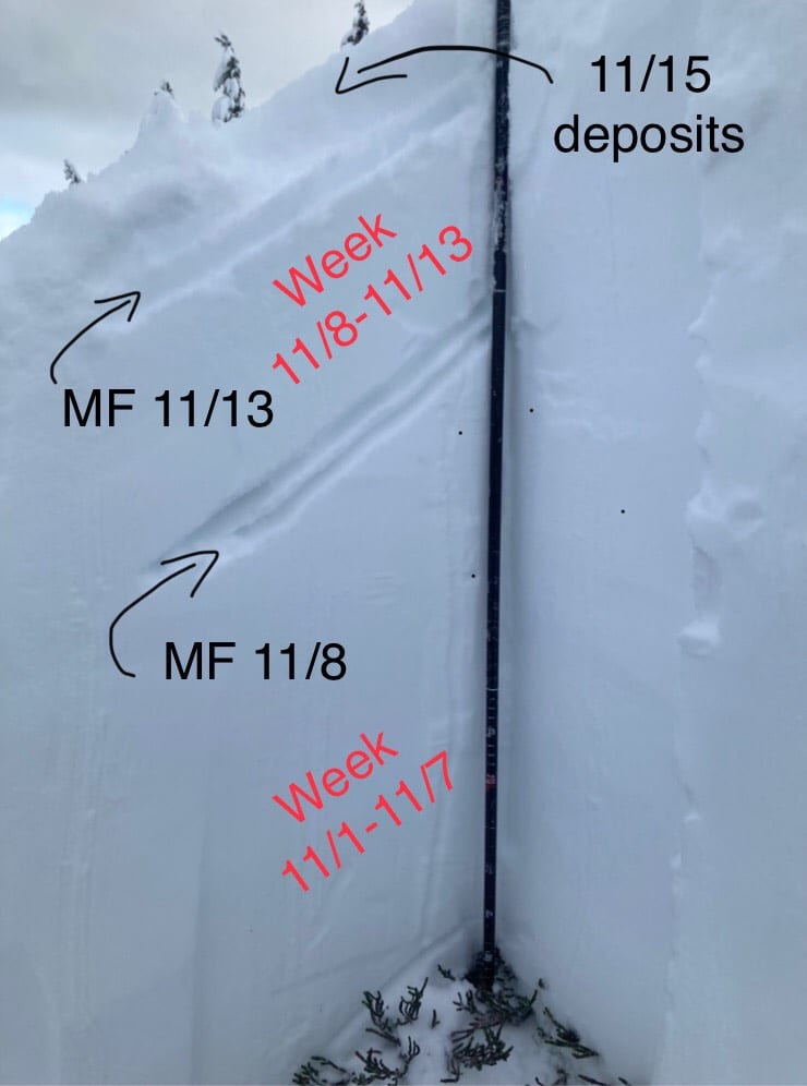 In areas above treeline, depth hoar exists at the ground. There are also 2 melt-freeze crusts just above this depth hoar and in the midpack. Any of these crusts can act as a bed surface and a weak interface within the old snow. Heavy new loading above these persistent layers has increased the likelihood of triggering these layers. This will be a problem on all aspects. Be especially cautious of steep, heavily wind-loaded areas above treeline, and unsupported slopes. Convexities, where there is a steep rollover, will be a likely place to trigger a deeper slab that runs to the ground with high consequences. This kind of danger is tricky and can be hard to manage, so a wide safety margin is recommended.
(Photo from Lutak Zone, 11/15, 2500ft, NE aspect)

Likelihood:
- Almost Certain
- Very Likely
- Likely
- Possible
- Unlikely
Size:
- Historic
- Very Large
- Large
- Small
Trend
- Increasing
- Steady
- Decreasing
Avalanche Activity
Please send in any observations of avalanche activity, including estimated depth, width, length, and location/elevation. Photos are great too.
Weather
We are stuck under the atmospheric river. As of 1pm Tuesday, we have received 2.5-3″ of water-equivalent, with perhaps 6″ more still to come over the next 48 hours. Snow levels are currently pretty low, but will be rising to 3000-4000ft. This is an ongoing major weather event. Snow totals so far include 34″ at Glacier creek (4,100ft), 22″ at Flower Mt., 14″ at the Pass, 12″ at Customs, 2-6″ in Haines, and around 36″ on Ripinsky (estimate based on incomplete data). Between getting buried and constant power outages, the weather stations are taking a beating and struggling to keep up. Ripinsky station especially.
| Snow Depth [in] | Last 24-hr Snow/SWE [in] | Last 3-days Snow/SWE [in] | Today’s Freezing Level [ft] | Today’s Winds | Next 24-hr Snow/SWE | |
Mount Ripinsky @ treeline |
~90″ | 36″ / 3.00* | 36″ / 3.00* | 1,000 -> 4,000 | strong, variable | 18″ / 3.50 * |
Flower Mountain @ treeline |
58″ | 22″ / 2.50 | 22″ / 2.50 | 500 -> 3,000 | strong, E | 18″ / 3.00 * |
Chilkat Pass @ 3,100ft |
27″ | 14″ / 1.00 | 14″ / 1.00 | 500 -> 3,000 | strong, SE | 20″ / 2.00 * |
( *star means meteorological estimate )
Additional Information
It’s time to start thinking avalanche. Dust off your gear and make sure it is fully functional. Put new batteries in your beacons! Do a beacon practice to start the season and keep your skills fresh. If you head into the hills, watch out for avalanche conditions, and be especially careful of rocks and hidden hazards like crevasses beneath the snow. WEAR A HELMET!
Education Video Links:
- AIARE
- How to Practice Avalanche Rescue Snowmobile Edition: https://youtu.be/2ML499MMDfM
- AK Sled Shed Motorized Learning:
- Intro: https://youtu.be/aoagKHfGkxs
- Personal Electronics in Avalanche Terrain: https://youtu.be/2Vz9S0OEyFk
- Snowmobile Macgyver Tool Kit: https://youtu.be/4WBNu_t6Bbk
- Head and Face Protection: https://youtu.be/jIzW89wOyZI
- Pre-season prep: https://youtu.be/zJmrb8cZlR4
- My Transceiver: https://youtu.be/yblaDWP7Jf8
- BCA Avalanche Safety for Snowmobilers
- How to Fix Common Snowmobile Problems in the Field: https://youtu.be/g9fiTxEvuFk
- Sleducation: Avalanche Safety for Snowmobilers: https://youtu.be/EWFOd_9DYb8
- Intro to Avalanche Transceivers for Snowmobilers: https://youtu.be/6ZLSBmsceog
- Avalanche Transceiver Trailhead Test for Snowmobilers: https://youtu.be/rWoXbadFBsY
- Avalanche Transceiver Searching Use Snowmobiles: https://youtu.be/w1ucyI6LMXM
- BCA Avalanche Rescue Series
- Beacon Search 101: https://youtu.be/nnHXLVA2FcE
- Avalanche Probing 101: https://youtu.be/-0_yDN5Drzw
- Avalanche Shoveling 101: https://youtu.be/dGQg9o3vAkM
- Organizing a Backcountry Rescue: https://youtu.be/gywtmukgt8s
- Post Avalanche Patient Care: https://youtu.be/9FyIeUy4wpQ
- Backcountry Evacuation: https://youtu.be/WPF-dciefL8
- Complex Multiple Burials Backup Techniques: https://youtu.be/pB6AfY2KyYo
- National Avalanche Center
- Avalanche Problems Explained: https://youtu.be/DkbnT_9-cHU
- Intro to North American Avalanche Danger Scale: https://youtu.be/r_-KpOu7tbA
Alerts
Avoid all avalanche terrain and lower runouts for the next few days. Natural avalanches are certain. Read the full details for more info. Also beware of roof avalanches which can be fatal.
Announcements
We have begun periodic conditions updates for winter 2020/2021. Click the + Full Forecast link below for each zone to read more.