Valdez
Above 3,000ftModerate
1,500 to 3,000ftConsiderable
Below 1,500ftModerate
Degrees of Avalanche Danger
Avalanche Problems
Problem 1
Surface Hoar was buried beginning 1/3 with additional snowfall recorded 1/6 -1/8. The first reported human triggered avalanches occurred on this layer 1/8, see observations and avalanche activity section. This is a clear indication that enough new snow exists to activate (cause to fail) this weak layer in specific locations. Only steep convexities where reactive 1/8, this is a perfect example of how buried surface hoar is strong in compression and weak in shear. Meaning that on 1/8 trigger points existed on steep terrain features, where more moderate terrain in close proximity was not reactive. This situation will continue to change through the weekend and become more dangerous. Continued snowfall will bury this layer deeper and will also begin to make the snow above it more cohesive. As this happens trigger points will become more widespread and avalanches will propagate longer distances. It will be possible to experience good stability were this layer doesn’t exist, although it may exist with a change of aspect, elevation or location and be reactive. This can make snowpack assessment difficult and can catch even experienced users off guard.
The distribution of this layer will be important in the coming days/weeks. The mid elevation band (2000-4000′) north of Thompson Pass is where this layer is the most prominent, but has been reported in the Port of Valdez up to brush line as well. Gullies and shaded/protected terrain will also likely harbor buried surface hoar. Most reports from 12/31-1/2 indicated that SH went away in upper elevation start zones, but may exist in some locations up to ridge lines.
Public observations will be important in the coming days.

Likelihood:
- Almost Certain
- Very Likely
- Likely
- Possible
- Unlikely
Size:
- Historic
- Very Large
- Large
- Small
Trend
- Increasing
- Steady
- Decreasing
Problem 2
Fairly regular snowfall beginning 1/3 has deposited 1.78 inches of SWE to Valdez. This translates to ~2 feet of new snow for the mountains. Storms started as low density snow and have moved towards heavier snow as temperatures have been rising across our region. This set up causes the upper portion of the snowpack to be upside down and creates instabilities within the new snow. We are still within 24 hours of a snowfall event, allow the snowpack time to adjust. Human triggered avalanches 1-3 feet deep may fail at the 1/3 buried surface hoar layer. Conservative terrain choices will be necessary today. Avoid large avalanche slopes, steep convex terrain and terrain traps.
Moderate winds have been blowing from multiple directions on ridge tops. Wind was light at mid elevations 1/8. Watch for the redistribution of new snow and avoid loaded lee aspects off ridge lines or terrain features.
The continental zone saw a rapid warm up the night of 1/8 briefly reaching 33° at 46 mile. This is the first time this has happened to the most recent round of new snow in this location, and has created a sudden change in the surface snow. This will create considerable avalanche hazard for all elevations in this zone.

Likelihood:
- Almost Certain
- Very Likely
- Likely
- Possible
- Unlikely
Size:
- Historic
- Very Large
- Large
- Small
Trend
- Increasing
- Steady
- Decreasing
Avalanche Activity
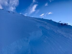
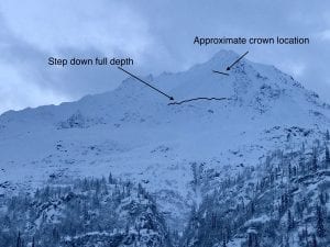
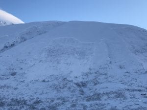
1/8- 3 separate skier triggered avalanches on Cracked Ice at 2800’/ 40 cms deep (16 inches)/ 100-300′ wide/ ran 600-700 feet and failed on the 1/3 buried surface hoar layer. SS-AR-U-D1.5-2-O
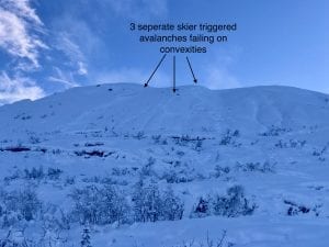
Lower section of far lookers left crown.
12/24- Observers reported remote triggered avalanches up to 100 meters away that were a meter deep. Tsaina trees below 3000′.
12/23- DOT mitigation work on snow slide gulch produced 3 D2.5’s that ran half of their path.
– HS-N-R3-D3-G, NW Crudbusters/ ~5000′
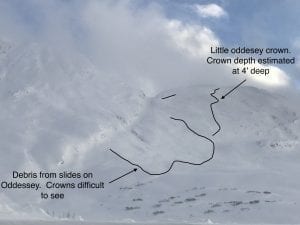
-Multiple D2-D2.5 slides on Oddessey and Little Oddessey. NW-N aspects. Only Little Oddessey crown was clear. ~100 yards wide, ~4′ deep.
-Natural D3 avalanche on Billy Mitchell NW-N aspects, originated ~5000′ stepped down to the ground around 4200′ in rocky terrain. Approximately 200 yards wide.
-Natural D2 avalanche activity was also noted on west aspects of 40.5 mile and Iguana Backs ~3500′. Further observations were prevented due to poor light.
12/20- A powder cloud reached the highway at the mp 42 slide path. “Three Pigs”. No other details available
-Numerous small (3-4″ deep) natural avalanches were observed in the Python and Cracked Ice Buttress area.
12/20- Multiple D1 soft slabs off Mt Cheddar Cheese Wedge (Hippie Ridge) originating from ~6500′
12/3- Numerous natural avalanches were observed north of Thompson Pass with many avalanches failing at the ground. Observations were not made south of Thompson Pass.
Avalanches observed from 46 mile towards Thompson Pass:
Three Pigs: Nearly every path on the SE face ran with debris deposits stopping in the top 1/3 of aprons, thick alders prevented slides from running full path. These were mostly D3 avalanches.
40.5 Mile Peak: Many paths running similar to Three Pigs, with one running full path to the Tsaina river. Mainly W-NW aspects, D3’s
Max High (Peak on the southern extent of Hippie Ridge) had a D3 avalanche with a crown near 5500′,SW aspect.
Upper Catchers Mitt bowl E aspect, slid R4-D3 ,triggering further avalanches lower down.
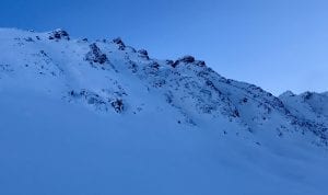
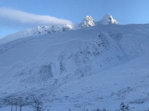
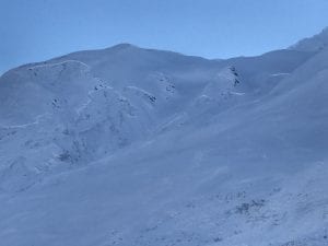
The main activity noted, was on the buttresses on the east side of the pass, from Cracked Ice through North Odessey Gully. Every buttress had significant avalanche activity originating ~4000-5000′. Many of these failed at the ground, north – northwest aspect. Pictures below.
School Bus and North Odyssey Gully both ran with debris in the runouts.
Many other large to very large natural avalanches occurred.
12/2- DOT reported a natural D2.5-3 avalanche that hit the Lowe river at Snowslide Gulch.
11/30- Natural avalanche observed on 40.5 mile peak just to the South of the Shovel. West aspect, ~4500′, crown ~200′ wide, poor light prevented further observation. SS-N-R1-D2-U.
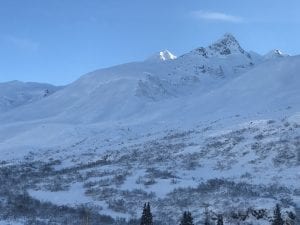
11/29: Natural avalanche observed on Billy Mitchell Cry babys shoulder, similar elevation as 11/16 slide but originated a couple hundred meters further west. Released from ~4000′ with a crown length of ~ 200 meters, North aspect, ~ 37°, failed at the ground. HS-N-R2-D2.5-G
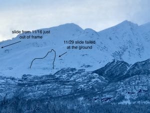
11/16: Natural avalanche observed on Billy Mitchell “Cry babys shoulder”. Released from~3500′ with a crown length of ~200 meters, North aspect. This slide was triggered by recent NE wind cross loading the slope. SS-N-R2-D2-U
11/15: Natural avalanche observed in Loveland Basin on a South aspect, down the ridge from Tones Temple. This slide was triggered by recent NE wind loading and failed at the ground. SS-N-R1-D2-G
Weather
1/9: 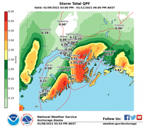
The Thompson Pass Mountain Forecast covers the mountains (above
1000 ft) surrounding Keystone Canyon through Thompson Pass to
Worthington Glacier.

This forecast is for use in snow safety activities and emergency
management.

                   Today        Tonight

Temp at 1000`      29 F         25 F

Temp at 3000`      24 F         26 F

Chance of precip   70%          70%

Precip amount
(above 1000 FT)    0.07 in      0.15 in

Snow amount
(above 1000 FT)    0-1 in       3-7 in

Snow level         sea level    sea level

Wind 3000` ridges  NE 15-30 mph NE 20-36 mph

Remarks...None.
| Date: 01/09 | 24 hr snow (inches) | HN24W (snow water equivalent inches) | High Temp (F) | Low Temp (F) | Weekly SWE Inches (Monday-Sunday) | January snowfall | Season snowfall | HS (snowpack depth inches) |
| Valdez | 4 | .2 | 37 | 21 | 1.87 | 24 | 122 | 52 |
| Thompson Pass | N/O | N/O | 27 | 23 | ? | ? | N/O | N/O |
| 46 Mile | 1 | .28 | 33 | 13 | 1.82 | 19 | 93 | 42 |
Thompson Pass weather history 20/21. Click on links above the images to see full size view
Additional Information
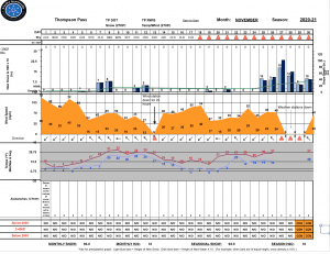
Our season began with a cold, dry and windy November which promoted faceting in the thin snowpack that existed. Only 28 inches of snow were recorded at Thompson Pass from 11/1 through 11/24.
November 25 began a series of storms that deposited 90” of snow and 11.1” of SWE on Thompson Pass at road level in an 8 day period. At the tail end of these storms the pass received 25” of snow and 3.7” of SWE in 48 hours, along with rising temps that pushed freezing line up to 3000’. This sparked a widespread natural avalanche cycle that failed on faceted snow created in early November. Many of these slides failed at the ground. See avalanche activity section for pictures of the cycle.
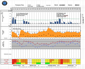
December continued with fairly regular snow fall and a couple periods of stable (dry) weather, with snowfall totaling 120 inches on Thompson Pass. Another, smaller natural avalanche cycle occurred on the 12/22 after Thompson Pass received 44 inches of snow with 4” of SWE in a 4 day period. Two full-depth naturals occurred in the Continental region on NW-N aspects between 4500-5000’ on NW Crudbusters and Billy Mitchell. Various other soft slab D2’s occurred in other regions as well. This indicated that depth hoar is still a concern in the Continental region but is becoming less so in our Maritime and Intermountain regions. Incremental snowfall during the second half of December has allowed the snowpack to slowly gain depth and strength.
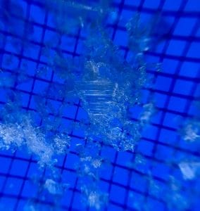
Cold, stable weather at the end of December created widespread areas of surface hoar up to 1 cm in height, observed on all aspects between 2000-4000’ and up to ridge lines in isolated locations. This layer was more concentrated on the north side of Thompson Pass, promoted by colder temperatures and an ice fog layer that was forming during this time frame. However, this surface hoar has been reported in the Port of Valdez up to brush line.
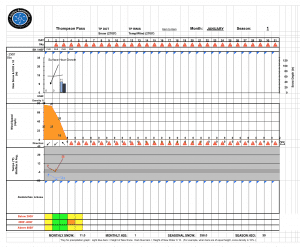
A small storm has recently buried this layer and it has become preserved in some locations. As snow continues to accumulate through this month it will be important to pay attention to the depth and distribution of the 1/3 Buried Surface Hoar layer.
Snowpack structure generally becomes thinner and weaker as you move North from Thompson Pass
Photos of Surface Hoar taken 1/1 on Crudbusters at 3500′ north aspect.
Announcements
The avalanche hazard is Considerable at mid elevations, and Moderate at low and upper elevations for the Maritime and Intermountain zone. In the Continental zone the avalanche hazard is Considerable at all elevations. Continued snowfall is continuing to stress faceted weak layers in our upper snowpack created during the new years dry spell. Human triggered avalanches will be likely in specific locations for the mid elevation band in steep and/or convex terrain. Pay attention to what the slope you are traveling on drains into. Choosing terrain that ends in alluvial fans is much safer than those that end in flat benches, depressions, or gullies, these are terrain traps and even shallow avalanches can pile up deeply and bury, injure or kill a person. The avalanche hazard will be increasing this weekend with periods of heavy snow and strong storm winds forecasted for the next 72 hours.
For more information click the (+full forecast) button below.
Help to improve your community avalanche forecast! Visit our observation page to leave a comment or you can email me directly at [email protected].