Haines Avalanche Center
Above 2,500ftNone
1,500 to 2,500ftNone
Below 1,500ftNone
Degrees of Avalanche Danger
Avalanche Problems
Problem 1
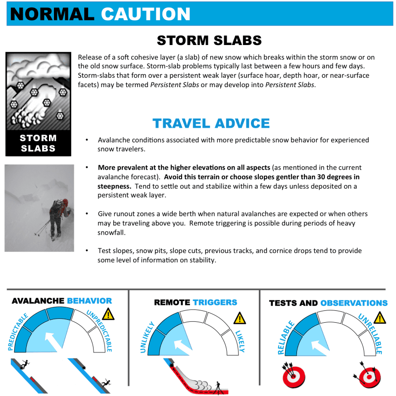 As new snow begins falling Saturday and becomes heavy, fresh storm slabs will be building in open areas above treeline. When these slabs build to about 4″ or deeper they begin to pose a threat. These fresh slabs will be quite touchy and poorly bonded to the underlying snow surface (new/old snow interface). Be careful to avoid terrain traps where small amounts of snow can pile up deeply.
(Click to enlarge graphic to read more…)

Likelihood:
- Almost Certain
- Very Likely
- Likely
- Possible
- Unlikely
Size:
- Historic
- Very Large
- Large
- Small
Trend
- Increasing
- Steady
- Decreasing
Problem 2
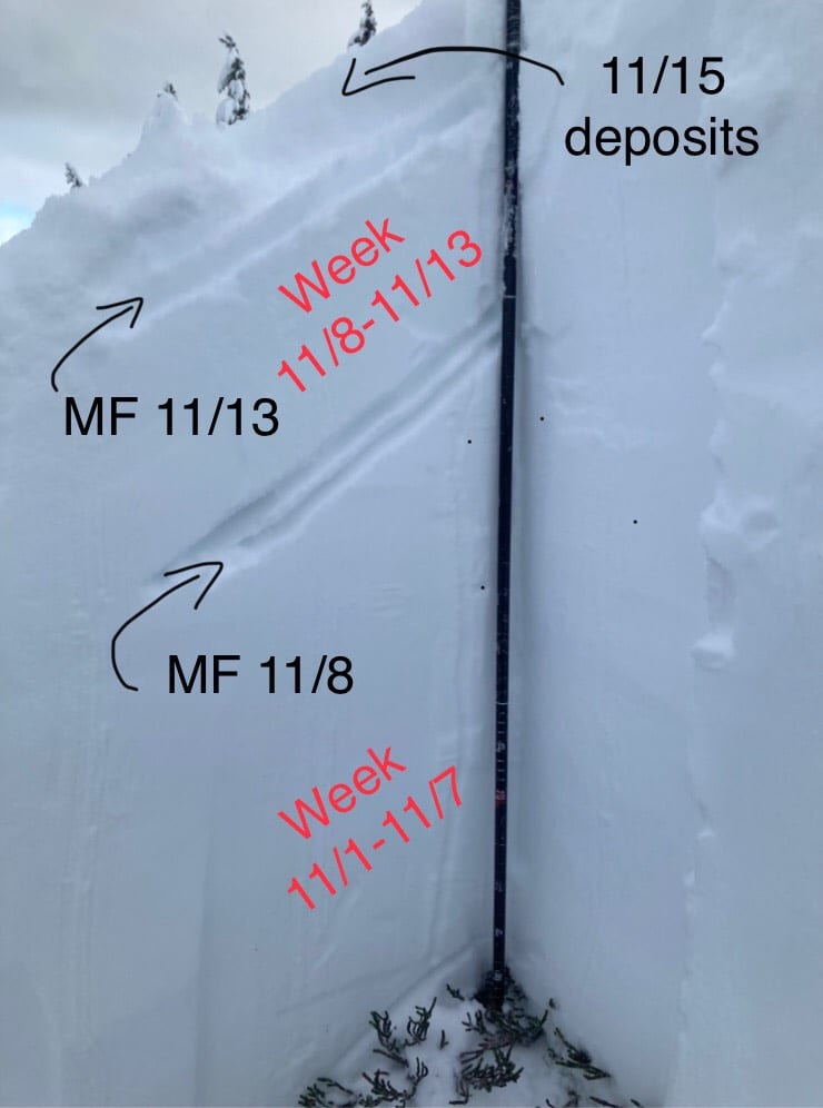 In areas above treeline, depth hoar exists at the ground. There are also 2-3 rain/melt-freeze crusts above just above this depth hoar and in the midpack. Any of these crusts can act as a bed surface and a weak interface within the old snow. This will be a problem on all aspects. Be especially cautious of steep, heavily wind-loaded areas above treeline, and unsupported slopes. Convexities, where there is a steep rollover, will be a likely place to trigger a deeper slab that runs to the ground with high consequences. This kind of danger is tricky and can be hard to manage, so a wide safety margin is recommended.
(Photo from Lutak Zone, 11/15, 2500ft, NE aspect)

Likelihood:
- Almost Certain
- Very Likely
- Likely
- Possible
- Unlikely
Size:
- Historic
- Very Large
- Large
- Small
Trend
- Increasing
- Steady
- Decreasing
Weather
6-12″ of new snow fell Nov 12-13, with a melt-freeze crust in the middle. After that, temperatures cooled down again and NW winds blew hard on the 18th.
We are expecting a storm coming in Saturday-Sunday, with 6-10″ of new snow likely. Winds should be light-moderate NW. More heavy snow is likely with a new storm on Monday-Tuesday. Temperatures will remain below freezing at sea level into next week.
| Snow Depth [in] | Last 24-hr Snow/SWE [in] | Last 3-days Snow/SWE [in] | Today’s Freezing Level [ft] | Today’s Winds | Next 24-hr Snow/SWE | |
Mount Ripinsky @ treeline |
26″ | 0″ / 0.00 | 0″ / 0.00 | 0 | Mod, NW | 0″ / 0.00 * |
Flower Mountain @ treeline |
12″ | 0″ / 0.00 | 0″ / 0.00 | 0 | Mod, NW | 0″ / 0.00 * |
Chilkat Pass @ 3,100ft |
2″ | 0″ / 0.00 | 0″ / 0.00 | 0 | Mod, NW | 0″ / 0.00 * |
( *star means meteorological estimate )
Additional Information
It’s time to start thinking avalanche. Dust off your gear and make sure it is fully functional. Put new batteries in your beacons! Do a beacon practice to start the season and keep your skills fresh. If you head into the hills, watch out for avalanche conditions, and be especially careful of rocks and hidden hazards like crevasses beneath the snow. WEAR A HELMET!
Education Video Links:
- AIARE
- How to Practice Avalanche Rescue Snowmobile Edition: https://youtu.be/2ML499MMDfM
- AK Sled Shed Motorized Learning:
- Intro: https://youtu.be/aoagKHfGkxs
- Personal Electronics in Avalanche Terrain: https://youtu.be/2Vz9S0OEyFk
- Snowmobile Macgyver Tool Kit: https://youtu.be/4WBNu_t6Bbk
- Head and Face Protection: https://youtu.be/jIzW89wOyZI
- Pre-season prep: https://youtu.be/zJmrb8cZlR4
- My Transceiver: https://youtu.be/yblaDWP7Jf8
- BCA Avalanche Safety for Snowmobilers
- How to Fix Common Snowmobile Problems in the Field: https://youtu.be/g9fiTxEvuFk
- Sleducation: Avalanche Safety for Snowmobilers: https://youtu.be/EWFOd_9DYb8
- Intro to Avalanche Transceivers for Snowmobilers: https://youtu.be/6ZLSBmsceog
- Avalanche Transceiver Trailhead Test for Snowmobilers: https://youtu.be/rWoXbadFBsY
- Avalanche Transceiver Searching Use Snowmobiles: https://youtu.be/w1ucyI6LMXM
- BCA Avalanche Rescue Series
- Beacon Search 101: https://youtu.be/nnHXLVA2FcE
- Avalanche Probing 101: https://youtu.be/-0_yDN5Drzw
- Avalanche Shoveling 101: https://youtu.be/dGQg9o3vAkM
- Organizing a Backcountry Rescue: https://youtu.be/gywtmukgt8s
- Post Avalanche Patient Care: https://youtu.be/9FyIeUy4wpQ
- Backcountry Evacuation: https://youtu.be/WPF-dciefL8
- Complex Multiple Burials Backup Techniques: https://youtu.be/pB6AfY2KyYo
- National Avalanche Center
- Avalanche Problems Explained: https://youtu.be/DkbnT_9-cHU
- Intro to North American Avalanche Danger Scale: https://youtu.be/r_-KpOu7tbA
Alerts
Due to the US/Canada border closure, we have very limited information about conditions in the Chilkat Pass zone. Updates for this zone are based on conditions on the US side and may be quite different in the Pass. We will not be issuing danger ratings for the Pass this season.