Haines Avalanche Center
Above 2,500ftModerate
1,500 to 2,500ftModerate
Below 1,500ftLow
Degrees of Avalanche Danger
Avalanche Problems
Problem 1
The Bottom Line: Sub-zero temperatures in the alpine have rotted out buried weak layers below and around melt-freeze crusts. The probability of triggering one of these widespread layers could increase with warming temperatures and today’s inversion. A shallow and variable early season snowpack, along with the unpredictable nature of the problem makes human triggered avalanches possible especially from thin spots around rocks, trees, or cliffs.
Mid-Pack Persistent Layers:
The unique weak layer in the midpack below a melt-freeze crust is buried about 50-70cm deep and formed Nov. 17 when temperatures spiked in the alpine and then refroze. The “Big Warmup” Layer has faceted, or become weak due to the arctic outflow and cold temperatures last week. With the low predictability of this unusual weak layer, a wide safety margin is necessary.
Test results from 12/1 in the Lutak zone found high strength within the “Big Warmup” layer but still failed and propagated. We know it to exist at all elevations above 1000ft — even up to the highest summits. We expect this layer (or other midpack crust-facet layers) to be an ongoing issue going forward.
Depth Hoar Formation:
Late October storms and November cold snaps created basal facets in thin areas above 1000ft. These facets haven’t been active yet, but the possibility still exists that an avalanche could fail at the ground in thin areas with a slab on top. This concern may grow into a deep slab problem over time if these facets weaken into depth hoar with single digit temperatures like we had last week.
Snow pit photo from Lutak zone 12/1, and profile from 11/26.


Likelihood:
- Almost Certain
- Very Likely
- Likely
- Possible
- Unlikely
Size:
- Historic
- Very Large
- Large
- Small
Trend
- Increasing
- Steady
- Decreasing
Problem 2
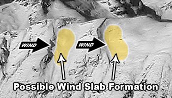
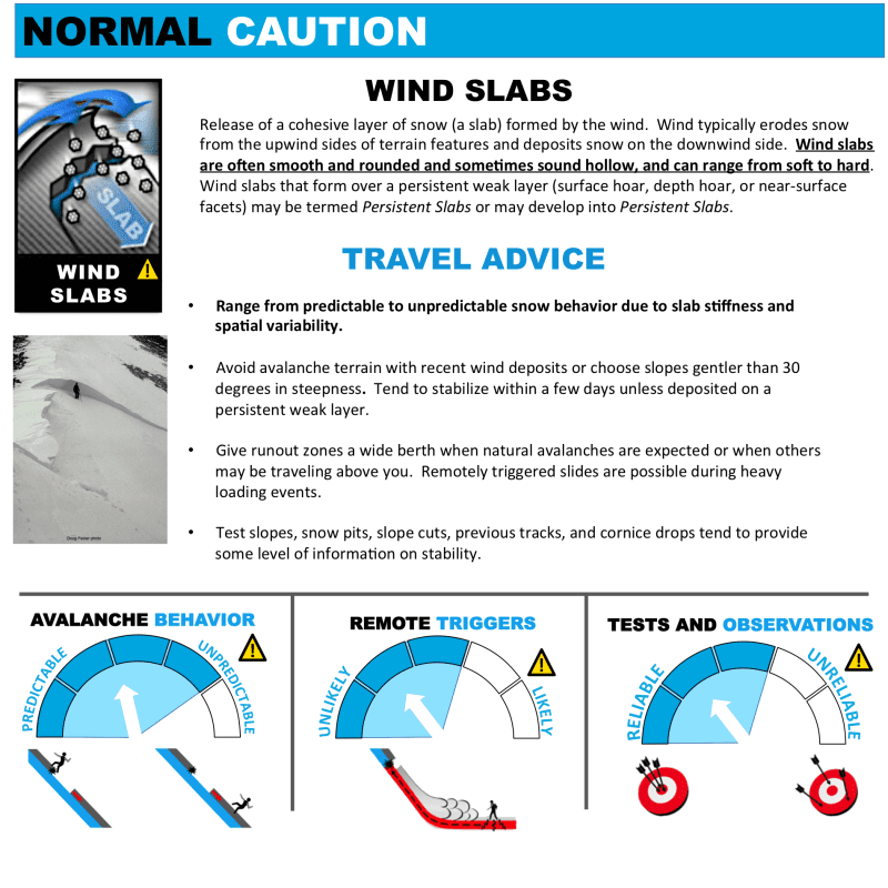
Very stiff wind slabs, from several days of strong NW winds are still at the surface of our snowpack on SW-S-SE-E aspects and terrain features like cross-loaded gullies. Wind slabs 1-2ft thick remain possible for human triggering. These surface wind slabs could also step down to persistent weak layers.
Wind loaded slopes and cross-loaded gullies should be avoided or carefully managed. You can tell if a slope is wind loaded by the filled-in, rounded or pregnant shape of the snow. Probe around for hollow, slabby surface snow. Minimize your exposure to these slopes, and always travel one-at-a-time through any suspect areas. Rocks will be a major safety hazard as well, so take it slow and easy, and keep your avalanche eyeballs on, especially in wind loaded areas and convexities! Avoid terrain traps!

Likelihood:
- Almost Certain
- Very Likely
- Likely
- Possible
- Unlikely
Size:
- Historic
- Very Large
- Large
- Small
Trend
- Increasing
- Steady
- Decreasing
Avalanche Activity
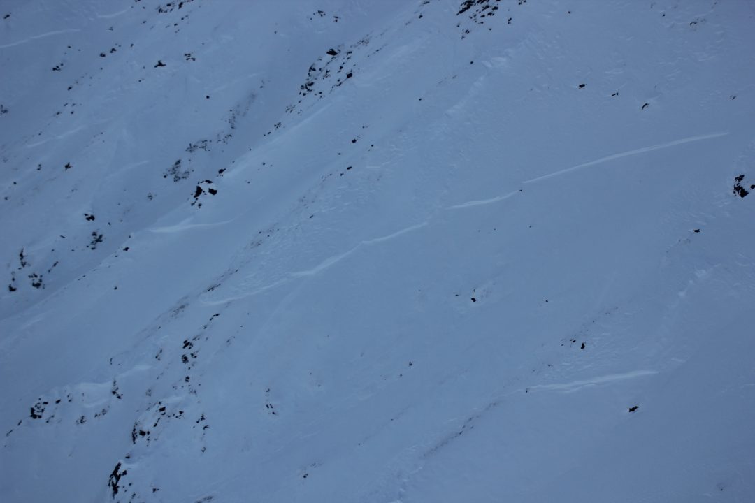
Flower Mt. area, D2 wind slab near 4,000′ on E-NE aspects in cross loaded gullies and terrain features
Photo from 12/2 in the Transitional Zone Credit: Forecaster, Erik Stevens
(Click to enlarge)
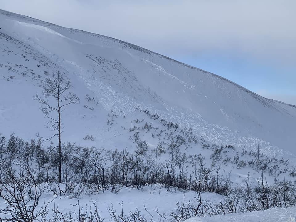
We have had reports this week of natural D2 wind slab avalanches in cross loaded gullies.
Photo from 11/29 of a wind slab avalanche near 3 guardsmen, NE aspect at 3200ft, Credit: Dan Egolf
Weather
Forecast:
Clear skies and generally calm conditions as high pressure prevails bringing with it an inversion. Cold temperatures will be stuck in the valleys while warming occurs up in mountain areas.
Seasonal Summary:
- An arctic outbreak brought very cold temperatures and strong NW winds Nov 27-Dec 2nd
- Nov 20-25 brought about 2ft of new snow above 2000ft (about 1ft in the Pass zone)
- Mid November was very warm, with temperatures reaching over 40F at 5000ft
- Cold weather set in Nov 4th – 9th, with alpine temps down to 8F at times
- A NW wind event Nov. 6th blew away much of snow in exposed areas
- 2 to 3ft of snow fell in Early November down to sea level
- October 26-27th brought in 5-12″ of heavy wet snow above 1500ft
- The first layer of snow to remain into winter fell above 3,500ft on Oct 21st. It was 6-12″ deep.
| Snow Depth [in] | Last 24-hr Snow/SWE [in] | Last 3-days Snow/SWE [in] | Today’s Freezing Level [ft] | Today’s Winds | Next 24-hr Snow/SWE | |
| Mount Ripinsky @ 2,500′ | 48″ | 0″ / 0.00″* | 0″ / 0.01″* | 0′ | light, NW | 0″ / 0.00″* |
| Flower Mountain @ 2,500′ | 27″ | 0″ / 0.00″ | 0″ / 0.00″ | 0′ | light, NW | 0″ / 0.00″* |
| Chilkat Pass @ 3,100ft | 4″ | 0″ / 0.00” | 0″ / 0.00″ | 0′ | light, NW | 0″ / 0.00″* |
( *star means meteorological estimate )
Additional Information
It’s time to start thinking avalanche. Dust off your gear and make sure it is fully functional. Put new batteries in your beacons! Do a beacon practice to start the season and keep your skills fresh.
If you head into the hills, watch out for avalanche prone areas, and be especially careful of rocks and hidden hazards like crevasses beneath the snow. WEAR A HELMET!
Announcements
We have begun regular forecasting for this winter (Fridays-Sundays). Click the Full Forecast link below to read more. Please submit your observations if you head out into the hills!