Haines Avalanche Center
Above 2,500ftConsiderable
1,500 to 2,500ftModerate
Below 1,500ftLow
The Avy Rose shows the forecasted danger by elevation and aspect. It adds more detail about where you are likely to find the dangers mentioned in the forecast. The inner circle shows upper elevations (mountain top), the second circle is middle elevations, and the outer circle represents lower elevations. Think of the Rose as a birds-eye view of a mountain, looking down from above. The rose allows our forecasters to visually show you which parts of the mountain they are most concerned about.
Degrees of Avalanche Danger
Avalanche Problems
Problem 1
Aspect: All Aspects
Elevation: Above Tree Line
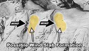
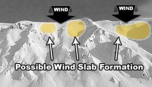
Bottom Line: Fresh and old hard wind slabs are lurking in specific areas and below prominent terrain features due to a reverse wind loading event earlier in the week. Due to recent light precipitation, it is very difficult to identify where these areas may be located. All aspects above tree line could contain pockets of these hard slabs located at ridge lines, peaks and passes. As new snow buries these areas of concern, it will become more difficult to identify suspect slopes so terrain should be evaluated carefully. Natural avalanches are unlikely and human triggered avalanches are possible in these specific areas. With new deposits this weekend falling over weak surface snow and a hard crust, conditions are primed for a future sliding surface. Be on the look out for fresh wind deposits, increasing temperatures and any significant load.
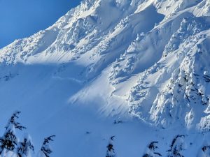
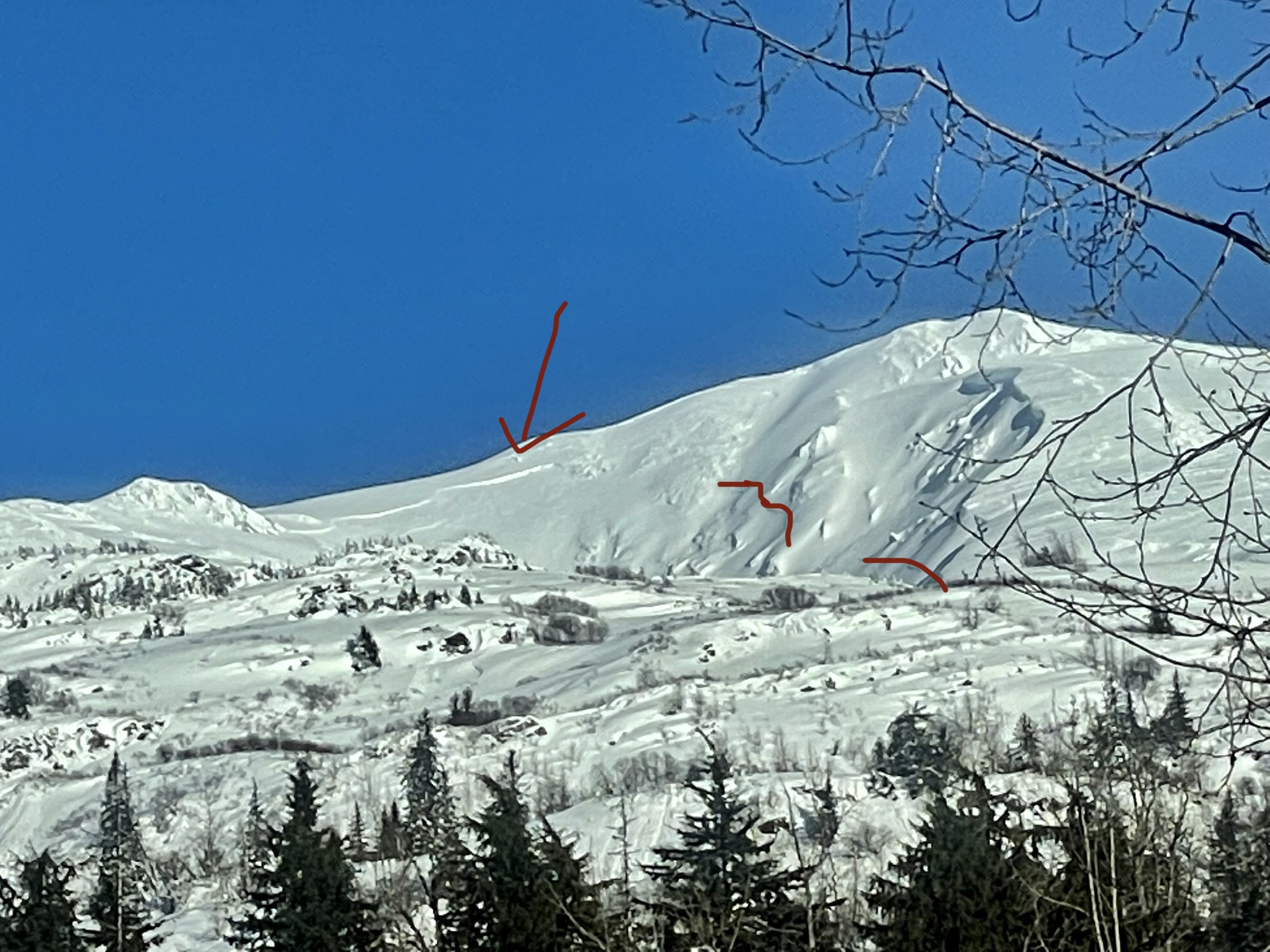
Photo from 2/23/2022 on the Skyline Trail of Ripinski. Note the rime ice snow in the foreground and the softer, wind deposited snow just under the terrain feature on a leeward (NW) aspect.
Travel Advice:
- Avoid slopes where the new snow was loaded and created surface wind slab.
- Identify and avoid shallow areas including trigger points around rocks, cliffs, and trees.
- Look for signs of snow that has been moved around by the wind (scouring and pillows of wind slab).
- Look, listen and feel for shooting cracks, collapses and hollow sounds.
- Avoid terrain trap areas such as cliffs and gullies, and areas where it is hard to escape off to the side.
Additional Consideration:
We believe deeper persistent layers are currently dormant. However, you could still trigger a persistent slab in thin or shallow snow even if we haven’t had recent feedback or avalanche activity. With the end of February comes a higher sun angle than we have seen for the last couple months. Surface warming will begin to be prevalent on solar days, especially around exposed rocks and creating thin and/or weak spots where you could trigger these deeper layers. Remember that persistent slabs are unpredictable and that tests and observations can be unreliable. A probe can be very helpful to determine snow depth and presence of deeper buried weak layers by noting resistance as the probe moves through the snow. Continue to use wide margins of safety, collect information and be patient when it comes to more committing terrain.

Likelihood:
- Almost Certain
- Very Likely
- Likely
- Possible
- Unlikely
Size:
- Historic
- Very Large
- Large
- Small
Trend
- Increasing
- Steady
- Decreasing
Problem 2
Aspect: SE-W-NW
Elevation: Above Tree Line
Bottom Line: Between 3-6 inches of new snow fell yesterday with a potential for up to 4 inches of snow today accompanied with Strong NE-E winds. Remember that wind can transport snow 10 times faster than snow falling from the sky. On slopes steeper than 35 degrees and on SE-W-NW aspects natural avalanches are possible and human triggered avalanches are likely in specific terrain. Leeward mountain features where greater amounts of snow can collect, such as below ridge lines, are areas of concern. Previous wind loaded areas from earlier in the week that occurred on all aspects will be nearly impossible to identify (See Persistent Slab Problem), and a new wind load may be enough to tip the scales. Observations are limited due to low visibility and this could create challenging route finding where you may not notice wind loaded areas until you’re on top of them.
Travel Advice:
- Avoid slopes where the new snow was loaded and created surface wind slab.
- Identify and avoid shallow areas including trigger points around rocks, cliffs, and trees.
- Look for signs of snow that has been moved around by the wind (scouring and pillows of wind slab).
- Look, listen and feel for shooting cracks, collapses and hollow sounds.
- Avoid terrain trap areas such as cliffs and gullies, and areas where it is hard to escape off to the side.

Likelihood:
- Almost Certain
- Very Likely
- Likely
- Possible
- Unlikely
Size:
- Historic
- Very Large
- Large
- Small
Trend
- Increasing
- Steady
- Decreasing
Avalanche Activity
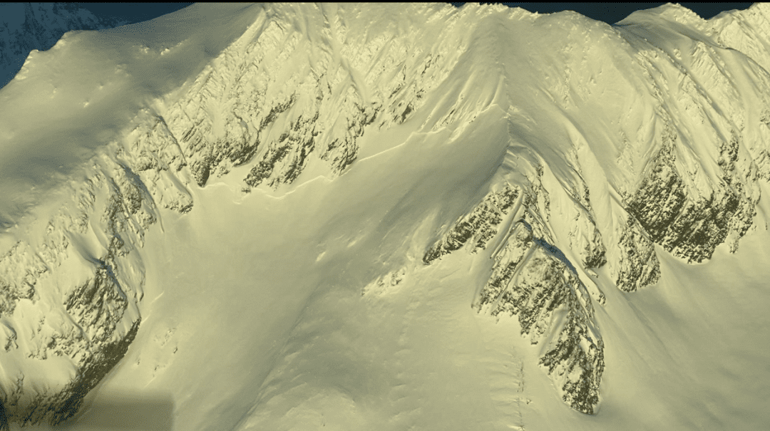
First Photo: Deep slab natural avalanche that occurred roughly 1/29 in the Lutak Zone. This slide may have run on a buried facet layer from late December’s outflow event, or even a deeper rain crust near the ground (it went all the way to ground in spots).
Last two photos: From 1/29 to 2/1, several reports came in of recent avalanches in the alpine of the Transitional Zone. The common characteristics of these slides were wide propagation, and failing 2-5ft deep at the interface below the wind slabs from last week’s atmospheric river. We have strong reason to suspect these slides occurred on a buried surface hoar layer from 1/20. They happened on all aspects, at elevations from 3000 – 5000ft, and all were in wind sheltered areas below ridges, features, and starting zones. Slide were observed in the Transitional and Lutak zones, but the Lutak slides appear to be on different layers.
4Winds zone. SW. 4000-5000′
Near Mt. Kraus.
Weather
Forecast:
Light precipitation continues to be the trend for today as 2-4” of snow is expected above 1,000′ with around 3” out the highway at the border. Expect to see freezing levels around 100′ then climbing to 800′ throughout the day. Moderate NE-E winds gusting at times to Strong. Temperatures will hover near freezing.
Seasonal Summary:
- Feb 16-19th light snow 3-4″ with freezing levels reaching 1,500′ with strong south winds.
- Feb 12-14th had freeze/thaw cycles that locked up the snowpack to ~4,000′.
- Feb 5th-9th brought snow levels near 3,500ft, and 2.5-4″ of SWE with strong south winds.
- Feb 1st-4th brought in 12-24″ of low density powder.
- Jan 27-29 brought 1.5 – 2.4″ of SWE with freezing levels near 1500ft.
- An Atmospheric river hit Jan 21-22. It brought in 2-7″ of SWE (2-5ft of snow above 2500ft, mostly rain below)
- Jan 9th-15th brought 24-48″ of new snow in the alpine, with some light rain up to 3,500ft, followed by heavier rain up to 2000ft.
- Very strong NW winds and arctic temperatures blasted the area the first week of January.
- Jan 1st: New snow (20″ in Lutak, 7″ Transitional zone) buried any preserved surface hoar.
- Moderate NW winds hit exposed slopes Dec 19-20th.
- Surface hoar formed on all aspects and elevations Dec 17-18th.
- December brought in about 2-5 feet of snowfall (highest in Lutak zone), and a few strong NW wind events.
- November brought consistent heavy snowfalls, cold weather, and SE winds.
- October brought heavy snow in the alpine, followed by a few rain/sun crusts.
| Snow Depth [in] | Last 24-hr Snow/SWE [in] | Last 3-days Snow/SWE [in] | Today’s Freezing Level [ft] | Today’s Winds | Next 24-hr Snow/SWE | |
| Mount Ripinsky @ treeline ** | 125″* | 5″ / 0.6″* | 7” / 0.8″* | 800′ | Strong- NE-E | 4″ / 0.4* |
| Flower Mountain @ treeline | 68″ | 2″ /0.2″ | 3″ / 0.3″ | 800′ | Strong- NE-E | 4″ / 0.4″ |
| Chilkat Pass @ 3,100ft | 31″ | (Not Reporting) | (Not Reporting) | 800′ | Moderate- E | 6″ / 0.6” |
( *star means meteorological estimate )
** The Ripinsky weather station is in need of repair, and will likely be down until Summer.
Additional Information
Safe backcountry travel requires training and experience. You control your own risk by choosing where, when and how you travel. Ride rescue ready. Be prepared for an emergency. Prevent hypothermia. Carry bear spray. Winter is a high consequence environment.
Become a sustaining Haines Avalanche Center Member by clicking the poster or visiting dev.alaskasnow.org/joinHAC. Support local forecasts, observations, education and weather stations. Join a community of winter recreationalists. Benefit from collective knowledge and skills. Help keep your friends and family safe in the backcountry. Get a free limited edition mountain buff, or neck gaiter with a $50 membership (first 20 members!).
Practice like you play. Make sure all your rescue gear is fully functional and your beacon has NEW batteries. Make sure 1) everyone in the group has a functioning beacon, shovel and probe 2) knows how to use them and 3) has trained in companion rescue in the last year. Keep your skills fresh. If you head into the hills, watch out for red flag avalanche conditions, natural avalanches, whoomphing or collapsing, and shooting cracks.
Education Video Links:
- AIARE
- How to Practice Avalanche Rescue Snowmobile Edition: https://youtu.be/2ML499MMDfM
- AK Sled Shed Motorized Learning:
- Intro: https://youtu.be/aoagKHfGkxs
- Personal Electronics in Avalanche Terrain: https://youtu.be/2Vz9S0OEyFk
- Snowmobile Macgyver Tool Kit: https://youtu.be/4WBNu_t6Bbk
- Head and Face Protection: https://youtu.be/jIzW89wOyZI
- Pre-season prep: https://youtu.be/zJmrb8cZlR4
- My Transceiver: https://youtu.be/yblaDWP7Jf8
- BCA Avalanche Safety for Snowmobilers
- How to Fix Common Snowmobile Problems in the Field: https://youtu.be/g9fiTxEvuFk
- Sleducation: Avalanche Safety for Snowmobilers: https://youtu.be/EWFOd_9DYb8
- Intro to Avalanche Transceivers for Snowmobilers: https://youtu.be/6ZLSBmsceog
- Avalanche Transceiver Trailhead Test for Snowmobilers: https://youtu.be/rWoXbadFBsY
- Avalanche Transceiver Searching Use Snowmobiles: https://youtu.be/w1ucyI6LMXM
- BCA Avalanche Rescue Series
- Beacon Search 101: https://youtu.be/nnHXLVA2FcE
- Avalanche Probing 101: https://youtu.be/-0_yDN5Drzw
- Avalanche Shoveling 101: https://youtu.be/dGQg9o3vAkM
- Organizing a Backcountry Rescue: https://youtu.be/gywtmukgt8s
- Post Avalanche Patient Care: https://youtu.be/9FyIeUy4wpQ
- Backcountry Evacuation: https://youtu.be/WPF-dciefL8
- Complex Multiple Burials Backup Techniques: https://youtu.be/pB6AfY2KyYo
- National Avalanche Center
- Avalanche Problems Explained: https://youtu.be/DkbnT_9-cHU
- Intro to North American Avalanche Danger Scale: https://youtu.be/r_-KpOu7tbA
Announcements
Click the +Full Forecast button below to read the details. Please submit your observations if you head out!