Haines Avalanche Center
Above 2,500ftModerate
1,500 to 2,500ftModerate
Below 1,500ftModerate
Degrees of Avalanche Danger
Avalanche Problems
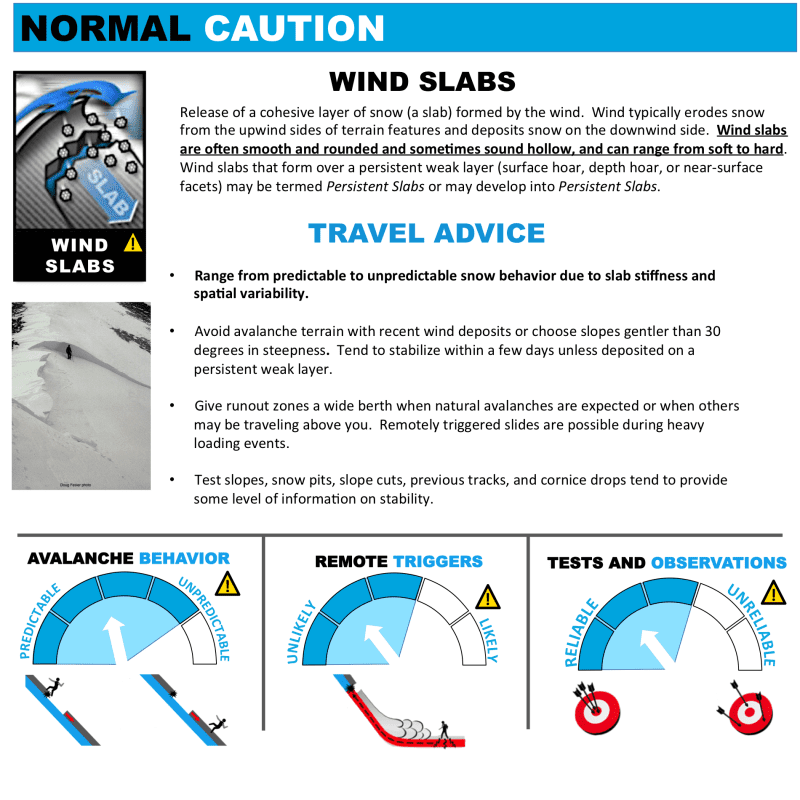
Problem 1
Aspect: Most likely on SW-S-SE-E-NE
Elevation: Most likely at and above Treeline
Travel Advice: Watch for red flags (shooting cracks, collapsing or recent natural avalanche activity). Stay away from slopes below ridgelines, roll-overs, or cross loaded gullies and other features steep enough to slide >30 degrees. Look for stiff, hallow, dense, drum-like slabs. Avoid terrain traps where snow could pile up quickly, or the consequences of a slide could cause injury or death.
Another note: Some very large cornices have formed on SW, S, and SE aspects. As always, be sure to give cornices the proper respect: stay WAY back. When they fail, they always break further back than you would expect.

Likelihood:
- Almost Certain
- Very Likely
- Likely
- Possible
- Unlikely
Size:
- Historic
- Very Large
- Large
- Small
Trend
- Increasing
- Steady
- Decreasing
Problem 2
Aspect: All aspects, most likely on wind loaded aspects and features SW-S-SE-E.
Elevation: All elevations.
Travel advice: Consider any possible slopes harboring surface hoar as guilty until proven innocent. Always use safe travel techniques such as only exposing one person at a time both on the way up and down. Identify and avoid thin areas where weak layers are more likely to trigger a slide from. Group up in safe zones that are out of harms way. Have good communication, including radios and a set plan in case of an emergency. Be practiced at companion rescue.
- On wind-protected slopes, there is preserved buried surface hoar about 5-10″ deep
- Snow and wind events in December created layers of slab and weak, facetted snow
- Cold temperatures Dec. 3-5th created weak snow at the surface that is now buried in many places
- Over a meter deep: old weak layers are buried and difficult to trigger, but still there.
- Toward the very bottom: early season snowfalls and crusts linger and are very difficult to trigger but are still of concern for step-down potential.
The persistent slab danger is not going away, it is standing by waiting for the right trigger. We have not had a crush and flush cycle, or stabilizing event. Keep in mind that most avalanches are triggered by someone in the group.
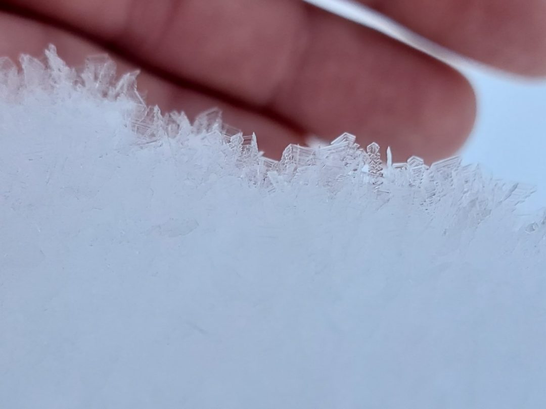
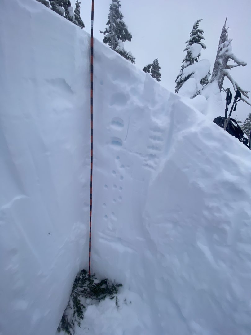
5-10mm surface hoar observed Dec. 18/ Test pit from Jan. 1st with buried crust 70cm down

Likelihood:
- Almost Certain
- Very Likely
- Likely
- Possible
- Unlikely
Size:
- Historic
- Very Large
- Large
- Small
Trend
- Increasing
- Steady
- Decreasing
Avalanche Activity
We had one report of a small skier-triggered soft slab 12/25 in the Lutak zone. It was on a cross-loaded S aspect gully, and likely ran on the 12/18 Surface Hoar layer.
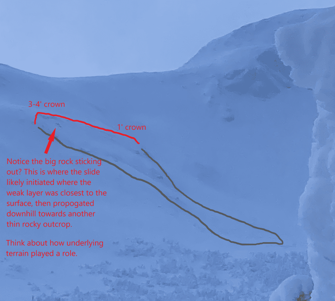
Dec 11th: Natural slide on mount Ripinsky’s back bowl caused by wind loading. It ran over a persistent weak layer on a NE aspect at 3,000ft, was 200ft wide and ran 800ft, with a average slope angle measured on Google Earth of 35 degrees.
Weather
Previous and Forecast:
Friday saw a significant rise in temps from the day before! Then cooled of again in the pm. Light to moderate Northerly outflow winds continued throughout the day. Winds will continue over night and into tomorrow. However by mid day they will start backing towards the South as the storm gets closer. Temps will remain in the single digits with broken to scattered skies. Precipitation will start late Saturday night.
Seasonal Summary:
- Very strong NW winds and arctic temperatures blasted the area the first week of January
- Jan 1st: New snow (20″ in Lutak, 7″ Transitional zone) buried any preserved surface hoar.
- Moderate NW winds hit exposed slopes Dec 19-20th
- Surface hoar formed on all aspects and elevations Dec 17-18th
- December brought in about 2-5 feet of snowfall (highest in Lutak zone), and a few strong NW wind events
- November brought consistent heavy snowfalls, cold weather, and SE winds
- October brought heavy snow in the alpine, followed by a few rain/sun crusts
| Snow Depth [in] | Last 24-hr Snow/SWE [in] | Last 3-days Snow/SWE [in] | Today’s Freezing Level [ft] | Today’s Winds | Next 24-hr Snow/SWE | |
| Mount Ripinsky @ treeline ** | 80″* | 0″ / 0.00* | 0″ / 0.00* | 0′ | mod, NW | 0″ / 0.00* |
| Flower Mountain @ treeline | 43″ | 0″ / 0.00 | 0″ / 0.00 | 0′ | mod, N | 0″ / 0.00* |
| Chilkat Pass @ 3,100ft | 14″ | 0″ / 0.00 | 0″ / 0.00 | 0′ | mod,N | 0″ / 0.00* |
( *star means meteorological estimate )
** The Ripinsky weather station is in need of repair, and will likely be down until Summer.
Additional Information
Ride rescue ready. Be prepared for an emergency. Prevent hypothermia. Carry bear spray. Winter is a high consequence environment.
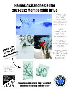
Become a sustaining Haines Avalanche Center Member by clicking the poster or visiting dev.alaskasnow.org/joinHAC. Support local forecasts, observations, education and weather stations. Join a community of winter recreationalists. Benefit from collective knowledge and skills. Help keep your friends and family safe in the backcountry. Get a free limited edition mountain buff, or neck gaiter with a $50 membership (first 20 members!).
Practice like you play. Make sure all your rescue gear is fully functional and your beacon has NEW batteries. Make sure 1) everyone in the group has a functioning beacon, shovel and probe 2) knows how to use them and 3) has trained in companion rescue in the last year. Keep your skills fresh. If you head into the hills, watch out for red flag avalanche conditions, natural avalanches, whoomphing or collapsing, and shooting cracks.
Education Video Links:
- AIARE
- How to Practice Avalanche Rescue Snowmobile Edition: https://youtu.be/2ML499MMDfM
- AK Sled Shed Motorized Learning:
- Intro: https://youtu.be/aoagKHfGkxs
- Personal Electronics in Avalanche Terrain: https://youtu.be/2Vz9S0OEyFk
- Snowmobile Macgyver Tool Kit: https://youtu.be/4WBNu_t6Bbk
- Head and Face Protection: https://youtu.be/jIzW89wOyZI
- Pre-season prep: https://youtu.be/zJmrb8cZlR4
- My Transceiver: https://youtu.be/yblaDWP7Jf8
- BCA Avalanche Safety for Snowmobilers
- How to Fix Common Snowmobile Problems in the Field: https://youtu.be/g9fiTxEvuFk
- Sleducation: Avalanche Safety for Snowmobilers: https://youtu.be/EWFOd_9DYb8
- Intro to Avalanche Transceivers for Snowmobilers: https://youtu.be/6ZLSBmsceog
- Avalanche Transceiver Trailhead Test for Snowmobilers: https://youtu.be/rWoXbadFBsY
- Avalanche Transceiver Searching Use Snowmobiles: https://youtu.be/w1ucyI6LMXM
- BCA Avalanche Rescue Series
- Beacon Search 101: https://youtu.be/nnHXLVA2FcE
- Avalanche Probing 101: https://youtu.be/-0_yDN5Drzw
- Avalanche Shoveling 101: https://youtu.be/dGQg9o3vAkM
- Organizing a Backcountry Rescue: https://youtu.be/gywtmukgt8s
- Post Avalanche Patient Care: https://youtu.be/9FyIeUy4wpQ
- Backcountry Evacuation: https://youtu.be/WPF-dciefL8
- Complex Multiple Burials Backup Techniques: https://youtu.be/pB6AfY2KyYo
- National Avalanche Center
- Avalanche Problems Explained: https://youtu.be/DkbnT_9-cHU
- Intro to North American Avalanche Danger Scale: https://youtu.be/r_-KpOu7tbA
Announcements
Bottom Line: As fresh/old winds slabs could still could be reactive and lingering persistent layers are still a concern, our main focus is on this inbound storm. A few important factors to keep in mind and watch out for.
- What is going on at the surface of the snow currently? Smooth or Rough? Firm or soft? Surface hoar or sugar snow?
- Note thin areas that could become likely trigger points.
- Cornice size and locations?
- Very important, track the freezing levels?
- Watch the rate of precipitation (snow or rain) vs time. Spread out over multiple days vs 12hr period?
- Wind direction, speed and duration.