Valdez
Above 3,000ftConsiderable
1,500 to 3,000ftConsiderable
Below 1,500ftModerate
Degrees of Avalanche Danger
Avalanche Problems
Problem 1

Likelihood:
- Almost Certain
- Very Likely
- Likely
- Possible
- Unlikely
Size:
- Historic
- Very Large
- Large
- Small
Trend
- Increasing
- Steady
- Decreasing
Problem 2

Likelihood:
- Almost Certain
- Very Likely
- Likely
- Possible
- Unlikely
Size:
- Historic
- Very Large
- Large
- Small
Trend
- Increasing
- Steady
- Decreasing
Problem 3
Likelihood:
- Almost Certain
- Very Likely
- Likely
- Possible
- Unlikely
Size:
- Historic
- Very Large
- Large
- Small
Trend
- Increasing
- Steady
- Decreasing
Avalanche Activity
12/26- Skier triggered avalanche on Cracked Ice Buttress: N aspect, 2500′, 37° slope, 18 inches deep, 100 feet wide, ran 200-300 feet. SS-ASu-D1-R1-I
12/24- Skier triggered avalanche on Python Buttress: NW aspect, 2700′, 35° slope, 60 feet wide, ran 200-300 feet. SS-ASu-D1.5-R1-O
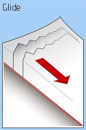
12/18- A large glide release was reported off Snowslide Gulch middle peak size 2.5.
12/15- Observed small natural avalanche on west aspect of Goodwills. Released below a cliff band at the bottom of a slope, 100′ wide. SS-N-D1-N
12/8- An observer witnessed a glide crack avalanche. SW aspect of peak 4690′ above the Valdez Glacier Lake. The debris reportedly ran all the way to the lake, with the deposition pile only feet away from a well used cross country ski trail.
Weather
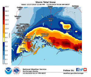
12/27- Winds were strong the night of 12/26, out of the NE, with gusts up to 50 MPH. Temperatures have fallen to single digits on Thompson Pass and NE wind will remain strong.
Our next storm will arrive tonight with a foot of snow expected for our area. There is a Blizzard Warning for Thompson Pass due to strong NE wind and heavy snow.
The Thompson Pass Mountain Forecast covers the mountains (above
1000 ft) surrounding Keystone Canyon through Thompson Pass to
Worthington Glacier.

This forecast is for use in snow safety activities and emergency
management.

                   Today        Tonight

Temp at 1000`      22 F         18 F

Temp at 3000`      10 F         6 F

Chance of precip   40%          100%

Precip amount
(above 1000 FT)    0.05 in      0.37 in

Snow amount
(above 1000 FT)    0-2 in       5-8 in

Snow level         sea level    sea level

Wind 3000` ridges  NE 15-30 mph NE 30-45 mph
| 24h snowfall (inches) | HN24W (inches)* | Hi Temp (F) | Low Temp (F) | Dec snowfall | Season Snowfall | Snow height | |
| Valdez | 3.5 | .15 | 33 | 20 | 29 | 53 | 28 |
| 46 mile | .5 | – | 25 | 9 | – | – | 12 |
|
Nicks snotel (4500′) |
0 | – | 21 | 4 | – | – | 105 |
HN24W= total water received last 24 hours in inches
Additional Information
With the combination of 3 feet of new snow and NE winds up to 50 mph, expect hazardous avalanche conditions in the mountains today. The 12/22-12/25 storm started with cold temperatures and very dry snow. As the storm has progressed, temperatures have been slowly warming and the snow is becoming heavier, making it upside down. In places, the snow is sitting on a persistent wind slab. In others, it is sitting on a faceted rain crust. There is a lot of variability out there but the outcome is the same for the short term: Avalanches. The new snow will need time to adjust. There is a lot of snow in the long term forecast – use caution as hazard could become more significant before it gets better.
There have been limited observations from interior locations due to low snow at lower elevations. Use caution if you travel in these areas.
If you have traveled in the mountains, please leave a public observation. The more info we can get from various locations will help us to get a clearer picture of the snowpack in our beautiful Valdez Chugach!
Forecast Confidence is Moderate.
Video taken 12/20 in the Mt. Dimond area showing reactive test slopes. https://vimeo.com/user106668057/review/380916811/02da5d1cc7
Announcements
The avalanche hazard is Considerable at mid and upper elevations. Human triggered avalanches are likely today and natural avalanches are possible on all aspects. Thompson Pass has received up to 3 feet of snow in the last week coupled with NE winds up to 50 MPH. The snowpack needs time to adjust and will be sensitive today. Avoid travel in steep terrain and above terrain traps. Expect hazard to increase with additional snowfall that will arrive Friday night.