Valdez
Above 4,000ftModerate
2,000 to 4,000ftLow
Below 2,000ftLow
Degrees of Avalanche Danger
Avalanche Problems
Problem 1

Likelihood:
- Almost Certain
- Very Likely
- Likely
- Possible
- Unlikely
Size:
- Historic
- Very Large
- Large
- Small
Trend
- Increasing
- Steady
- Decreasing
Problem 2

Likelihood:
- Almost Certain
- Very Likely
- Likely
- Possible
- Unlikely
Size:
- Historic
- Very Large
- Large
- Small
Trend
- Increasing
- Steady
- Decreasing
Problem 3
Likelihood:
- Almost Certain
- Very Likely
- Likely
- Possible
- Unlikely
Size:
- Historic
- Very Large
- Large
- Small
Trend
- Increasing
- Steady
- Decreasing
Avalanche Activity
12/10-The only new natural avalanche activity in the Thompson Pass corridor was small, wet point-releases off the Nicks and Python Buttresses. These originated from 3500-4000′ and did not entrain more snow.
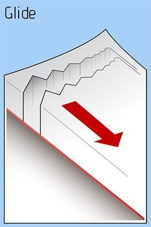
12/8- An observer witnessed a glide crack avalanche. SW aspect of peak 4690′ above the Valdez Glacier Lake. The debris reportedly ran all the way to the lake, with the deposition pile only feet away from a well used cross country ski trail.
Weather
Friday is forecasted for light snow with an inch or two of accumulation expected. Winds will be moderate out of the East. Highs in the mid 20’s for Thompson Pass.
The Thompson Pass Mountain Forecast covers the mountains (above
1000 ft) surrounding Keystone Canyon through Thompson Pass to
Worthington Glacier.

This forecast is for use in snow safety activities and emergency
management.

                   Tonight      Fri

Temp at 1000`      30 F         34 F

Temp at 3000`      31 F         30 F

Chance of precip   90%          70%

Precip amount
(above 1000 FT)    0.06 in      0.14 in

Snow amount
(above 1000 FT)    0-1 in       0-2 in

Snow level         sea level    800 ft

Wind 3000` ridges  NE 6-27 mph  E 12-28 mph
| 24h snowfall (inches) | HN24W (inches)* | Hi Temp (F) | Low Temp (F) | Dec snowfall | Season Snowfall | |
| Valdez | 0 | 0 | 36 | 26 | 7 | 31 |
| 46 mile | 0 | 0 | 25 | 21 | – | – |
|
Nicks snotel (4500′) |
0 | 0 | 32 | 29 | – | – |
HN24W= total water received last 24 hours in inches
Additional Information
Winds have shifted from onshore S/SE to offshore N/NE within the last 48 hours. This switch in wind direction will begin to load South facing slopes below ridge lines with fresh wind slab in locations that receive moderate to strong wind. 12/11 found 2 feet of 4-finger density windslab forming in specific locations. This new slab was cracking underfoot which is a sign that it has energy to slide and will need time to strengthen. Look for these slabs to grow in size if winds become stronger than forecasted or become widespread. Flagging on peaks and ridges will be a sure sign that windslab is building. In places that were unaffected by the wind, the new snow from 12/6-10 is bonding well to the old snow interface.
Below 3000′ there is a pencil hard rain crust and good stability.
If you venture into avalanche terrain today, use terrain progression as a tool. Start with small slopes that have no consequence, before committing to larger slopes.
If you travel in the mountains today, please leave a public observation. The more info we can get from various locations will help us to get a clearer picture of the snowpack in our beautiful Valdez Chugach!
Forecast Confidence is moderate.
Announcements
The avalanche hazard is moderate at upper elevations. Natural avalanches are unlikely today unless caused by a glide crack. Skier triggered avalanches are possible on steep terrain, or in areas that have been recently, or are actively being loaded by moderate north winds. Good indicators for windslab are a rapid increase in depth of the new snow over a short distance, shooting cracks and a hollow, drum-like feel. Use caution in the mountains today, watch for windslab and avoid terrain traps.