Valdez
Above 3,000ftConsiderable
1,500 to 3,000ftConsiderable
Below 1,500ftModerate
Degrees of Avalanche Danger
Avalanche Problems
Problem 1

Likelihood:
- Almost Certain
- Very Likely
- Likely
- Possible
- Unlikely
Size:
- Historic
- Very Large
- Large
- Small
Trend
- Increasing
- Steady
- Decreasing
Problem 2

Likelihood:
- Almost Certain
- Very Likely
- Likely
- Possible
- Unlikely
Size:
- Historic
- Very Large
- Large
- Small
Trend
- Increasing
- Steady
- Decreasing
Avalanche Activity
1/27-1/30: Naturals were observed on RFS, N aspect ~6000′,
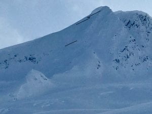
Avalanches were also observed on -40.5 mile, ~5000′ ,W aspect, 60 m crown
– 2 paths on Three Pigs, ~5000′, SE aspect, ran into the top 1/3 of aprons.
– 3 slides on Billy Mitchell ranging from 3000′-6000′, NW- N aspect. The most significant was on the upper bowl of cry babys, ~5000′, ~200 m crown, 1-2 meters deep.
1/23- Found fresh debris in a gully off point 3848′ behind the airport. D2, ran ~2000′.
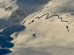
~ 1/10- There have been several natural windslabs that have released in the Thompson Pass region:
-South slope of catchers mitt, near 27 mile icefall,~3500′, ~300m wide ,~3′ deep, ran 500′ HS-N-R3-D2.5. Photo shows extent of crown, which may have been bigger and is now filled in by wind transported snow.
– Gully Between Little and Big Oddessey, NW, 4000′, ~60 M wide, ~2-4′ crown, ran 1000′
-Averys, ~4000′, SW, ~70 M wide, ran ~1000′
1/11- Two natural wind slab avalanches observed at moonlight basin, 2500′-2800′, S aspect.
The first was on the small last roll before the road and had debris chunks up to 3′ deep “crown filled in by wind”, 200′ wide.
The second was in a cross loaded gully ~ 300′ above the road, with a crown up to ~10′ deep, ~100′ wide. 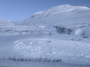
Weather
2/01- Moderate to strong NE winds are forecasted for our area today, and will increase in strength towards the afternoon hours. Temperatures will fall to below zero at Thompson Pass this evening.
The Thompson Pass Mountain Forecast covers the mountains (above
1000 ft) surrounding Keystone Canyon through Thompson Pass to
Worthington Glacier.

This forecast is for use in snow safety activities and emergency
management.

                   Today        Tonight

Temp at 1000`      10 F         -1 F

Temp at 3000`      -7- 1 F      -11- 5 F

Chance of precip   0%           0%

Precip amount
(above 1000 FT)    0.00 in      0.00 in

Snow amount
(above 1000 FT)    0 in         0 in

Snow level         sea level    sea level

Wind 3000` ridges  NE 10-32 mph NE 14-36 mph

Remarks...None.
| 24h snowfall (inches) | HN24W (inches)* | Hi Temp (F) | Low Temp (F) | February snowfall | Season Snowfall | Snow height | |
| Valdez | Trace | 0 | 24 | 0 | 0 | 107 | 42 |
| 46 mile | Trace | 0 | 13 | -9 | 0 | 61 | 23 |
|
Thompson Pass “DOT” |
– | – | 15 | -3 | 0 | 358 | 74 |
HN24W= total water received last 24 hours in inches
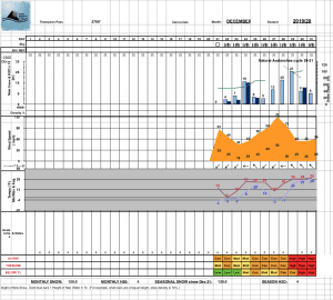
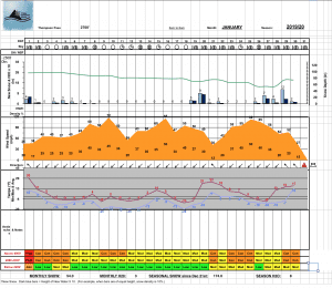
Thompson Pass weather history 19/20 season beginning 12/21 through 1/23. Click on links below to see full size image.
Additional Information
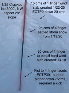
Our area has received 2 feet of new snow from storms beginning the 26th. This new snow has been redistributed by strong NE wind onto lee aspects (SE-NW) in areas exposed to wind. Beneath this new snow exists developed near surface facets up to 3mm, but is spatially variable. The variability of this layer may make decision making difficult. Good stability may be found on certain slopes while others even in close proximity may be prone to avalanches.
This layer of near surface facets is a weak layer in our upper snowpack and will have a difficult time adjusting to the weight of the new snow. This is evident by very large collapses rolling across terrain that have been experienced the last couple of days. Another good indicator is the fair amount of natural avalanche activity, especially toward 46 mile, which indicates this weak layer is more developed the further North you go from Thompson pass.
There is a lot of spatial variability beneath the layers mentioned above, mostly consisting of variable wind affected surfaces. These surfaces have gained a lot of strength and are creating a bridging effect above a faceted mid and lower snowpack. Poor structure exists in the mid and lower pack and although unlikely, still has the ability to create destructive avalanches. This set up is low probability, high consequence.
We have likely not seen the last effects from this faceted snow in the mid and lower snowpack. We may see this layer wake up if we see sufficient load, whether it be a significant snowfall, increase in temperatures, a large wind event with significant snow available for transport, or simply someone finding the sweet spot.
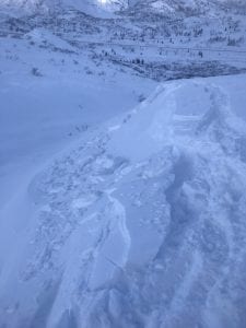
1/24 Photo of reactive test slope on a cross loaded gully, west aspect, ~2500′. See video in observations.
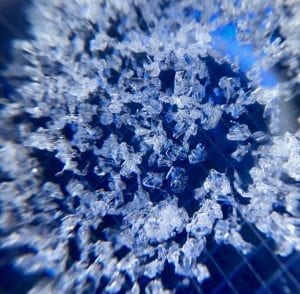
Near surface facets found at 3000′ on Billy Mitchell 1/19. 2 MM grid.
There have been limited observations from interior locations due to low snow at lower elevations. Use caution if you travel in these areas.
If you see something in the mountains that could contribute to this forecast, leave a public observation. The more observations we receive, the better we can tune our forecast.
Be aware that the elevation bands have changed on our website. Low is now below 2000′, Mid is 2000-4000′ and high is 4000′ and above.
Forecast Confidence is Moderate.
Announcements
The avalanche hazard is Considerable at mid and upper elevations. We have received 2 feet of new snow this week, beginning 1/26. NE winds were moderate to strong on 1/31 and will continue through 2/1. This wind will increase the hazard on lee aspects (SE-NW) of slopes that are receiving wind loading. Human triggered avalanches are likely today on recently wind loaded terrain and possible on slopes steeper than 30° that remain unaffected by wind. Avoid travel in large avalanche paths and above terrain traps.