Valdez
Above 4,000ftModerate
2,000 to 4,000ftModerate
Below 2,000ftLow
Degrees of Avalanche Danger
Avalanche Problems
Problem 1
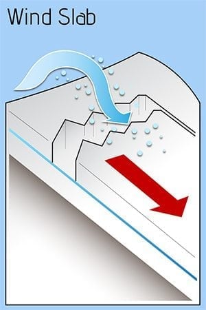
With snowpack depths of 3 feet plus at Thompson Pass and north, windslabs are building with strong northerly outflow winds. Places to watch are gully walls and steep slopes with sizable areas for the wind to fetch snow and deposit. With prolonged temps near zero F and below, the snowpack is faceting with bonds between the windslab and surfaces below weakening.
Likelihood:
- Almost Certain
- Very Likely
- Likely
- Possible
- Unlikely
Size:
- Historic
- Very Large
- Large
- Small
Trend
- Increasing
- Steady
- Decreasing
Avalanche Activity
November 9th rain on snow event produced many size 2 wet slides in steep terrain, multiple aspects above 2300′.
Announcements
November Early Season Caution!
Welcome to a new winter! Regular VAC forecasts will begin December 1st.
Until then, please share your observations to bolster our understanding of how the early snowpack is developing. Use travel techniques that reduce your exposure to unknown snow conditions above you: travel on ridges or high ground, notice changes in snowpack depth and density, observe how the snow is distributed over the terrain due to elevation and wind.
Make sure you and your partners have your backcountry brains turned on. Talk about avoiding potential hazards including:
- rocks and objects just under the thin snow coverage that could cause damage or injury
- windslab avalanche problem and what areas you agree to avoid
- hypothermia/cold weather injuries
Early Season shake down: Put fresh batteries in your avalanche beacons. Practice companion rescue with your crew. Test-pull your airbags. Get into the habit of talking about ride safely techniques and checking in often. Debrief your day and submit snow, weather and avalanche observations.
Bring on the snow and winter fun!
