Hatcher Pass
Above 3,500ft Moderate
2,500 to 3,500ft Moderate
Below 2,500ftModerate
Degrees of Avalanche Danger
Avalanche Activity
13″ New snow and moderate to strong winds were responsible for numerous avalanches this week.
For more info on the Natural and Human triggered avalanches from March 12 , check out the mid week summary, HERE or weekly OBSERVATIONS HERE.
Natural avalanches were also observed on March 14 and 15th, although exact details can not be confirmed due to poor weather conditions and low visibility. Most slab avalanches were observed on SW through NE aspects at mid and upper elevations and ranged from 6″-18″ deep, mostly small, but up to D2, large enough to bury, injure, or kill a person.
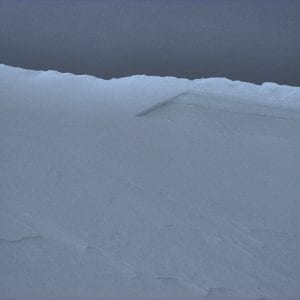
Above: Wind slab avalanche below Marmot ridge, 4000′ W aspect, likely 3/14.
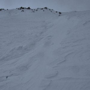
Above: Small wind slabs failed naturally on side walls of Marmot Mid-Rib, likely 3/14. Photo shows debris on the left, bed surface in the middle, cross loaded and sastrugi to the right. NW aspect, 3600′
3/14 D2 natural wind slab that appears to have stepped down. NW Martin Mine Gully 3900′. Picture HERE
Weather
This week’s weather at Independence Mine 3550′:
Temps averaged 23ºF, with a low of 13ºF and a high of 33ºF.
IM recorded 13” of new snow and .84″ water (SWE) this week.
Overnight at 3550′:
Temps averaged 33°F.
No new snow.
This week’s weather at Marmot Weather Station 4500′:
Temps averaged 20ºF, with a low of 10ºF and a high of 27ºF.
Winds averaged ESE 18 mph, max 39 mph . Gusts averaged ESE 20 mph, max gust ESE 53 mph.
Overnight at 4500′:
Temps averaged 26ºF overnight.
Winds averaged ESE/E14 mph overnight. Max gust ESE/E34 mph.
NWS Rec Forecast HERE
NWS point forecast HERE
State Parks Snow Report and Motorized Access information HERE
Additional Information
TREND
Expect warmer temperatures, some clouds and/or scattered snow showers, and winds SE 11-27 mph today . Avalanche danger will remain the same or trend towards LOW on Sunday if winds diminish. A lack of snow available for transport from southerly aspects will limit the formation of new wind slabs on leeward aspects on Sunday.
Alerts
Read entire HPAC advisory HERE.
Announcements
BOTTOM LINE
The avalanche danger is MODERATE today for Wind Slabs. Moderate to strong winds from 3/13-14 formed slabs 6″-18″ thick, that will be possible to human trigger at at mid and upper elevation, on leeward aspects, W to N , and cross-loaded SW aspects, on slopes above 35°. Natural avalanches are unlikely.
Low avalanche hazard at low elevation. Human triggered avalanches will be unlikely. Low hazard does not mean NO hazard.
A LOW hazard in the morning for Wet-Loose will rise to MODERATE in the afternoon, on steep slopes SE to SW at low and mid elevation.
Strong winds have blown most snow surfaces down to sun crust, old drizzle crust (CNY), and formed wind slabs. Snow conditions are challenging to say the least.
Announcements: Heading to Turnagain? Be sure to check the CNFAIC Forecast HERE. Avalanche Danger is HIGH for the fourth consecutive day.