Chugach National Forest
Above 2,500ftConsiderable
1,500 to 2,500ftModerate
Below 1,500ftModerate
Degrees of Avalanche Danger
Avalanche Problems
Problem 1

Likelihood:
- Almost Certain
- Very Likely
- Likely
- Possible
- Unlikely
Size:
- Historic
- Very Large
- Large
- Small
Trend
- Increasing
- Steady
- Decreasing
Problem 2

Likelihood:
- Almost Certain
- Very Likely
- Likely
- Possible
- Unlikely
Size:
- Historic
- Very Large
- Large
- Small
Trend
- Increasing
- Steady
- Decreasing
Problem 3
Likelihood:
- Almost Certain
- Very Likely
- Likely
- Possible
- Unlikely
Size:
- Historic
- Very Large
- Large
- Small
Trend
- Increasing
- Steady
- Decreasing
Avalanche Activity
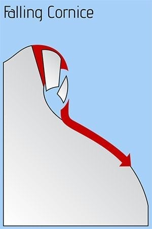
The avalanche danger remains CONSIDERABLE in the Alpine today. Human triggered slab avalanches 2-3′ thick are likely on steep slopes above 2000′. A MODERATE danger exists at Treeline and below where triggering an avalanche is still possible. Pay attention to changing conditions on solar aspects and with warming temperatures in the afternoon. Watch for roller balls and natural wet loose avalanche activity. Extra caution is advised. Give cornices a wide berth. SUMMIT LAKE: This area has a very shallow and weak snowpack. Strong winds combined with a few inches of snow during the weekend storm may have overload buried weak layers and caution is advised if heading to this area. Look for signs of instability. LOST LAKE: Caution is advised in the Seward region. New snow and wind over the weekend have created dangerous avalanche conditions. The potential for large human triggered avalanches remains in this area as well.
Weather
Yesterday: Mostly cloudy skies with rain/snow showers and rain/snow line fluctuating around 1000′. Temperatures were in the mid 20Fs to high 30Fs. Winds were mostly light and easterly shifting to the west in the evening. Overnight skies cleared and temperatures dropped ranging from just below freezing at sea level to the teens at upper elevations. Winds remained light.
Today: Mostly clear and sunny in the morning with clouds building later in the day and a chance of snow showers in the evening. Temperatures will be in the 20Fs to mid 30Fs. Winds will be easterly 5-15 mph with gusts into the 20s. Tonight will be mostly cloudy with temperatures in the 20Fs. Easterly winds will increase with gusts into the 30Fs. Snow showers overnight with 1-5″ forecast.
Tomorrow: Mostly cloudy skies with snow showers throughout the day and snow likely in the evening. Temperatures will be in the 20Fs and 30Fs. Easterly winds blowing 10-20 mph with gusts into the 30s increasing overnight. The position of the low in the Gulf with this system is a still a little uncertain and could impact how much precipitation the area receives. The most intense part of this storm still looks to be Wednesday night.
*Seattle Ridge wind sensor is not reporting.
PRECIPITATION 24-hour data (6am – 6am)
| Temp Avg (F) | Snow (in) | Water (in) | Snow Depth (in) | |
| Center Ridge (1880′) | 30 | 0 | 0.1 | 69 |
| Summit Lake (1400′) | 28 | 0 | 0 | 27 |
| Alyeska Mid (1700′) | 31 | 3 | 0.26 | 73 |
RIDGETOP 24-hour data (6am – 6am)
| Temp Avg (F) | Wind Dir | Wind Avg (mph) | Wind Gust (mph) | |
| Sunburst (3812′) | 21 | NE | 5 | 18 |
| Seattle Ridge(2400′) | 27 | *N/A | *N/A | *N/A |
This is a general backcountry avalanche advisory issued for Turnagain Arm with Turnagain Pass as the core advisory area (this advisory does not apply to highways, railroads, or operating ski areas).
Additional Information
The avalanche danger remains CONSIDERABLE in the Alpine today. Human triggered slab avalanches 2-3′ thick are likely on steep slopes above 2000′. A MODERATE danger exists at Treeline and below where triggering an avalanche is still possible. Pay attention to changing conditions on solar aspects and with warming temperatures in the afternoon. Watch for roller balls and natural wet loose avalanche activity. Extra caution is advised. Give cornices a wide berth.
SUMMIT LAKE: This area has a very shallow and weak snowpack. Strong winds combined with a few inches of snow during the weekend storm may have overload buried weak layers and caution is advised if heading to this area. Look for signs of instability.
LOST LAKE: Caution is advised in the Seward region. New snow and wind over the weekend have created dangerous avalanche conditions. The potential for large human triggered avalanches remains in this area as well.