Haines Avalanche Center
Above 2,500ftHigh
1,500 to 2,500ftHigh
Below 1,500ftConsiderable
Degrees of Avalanche Danger
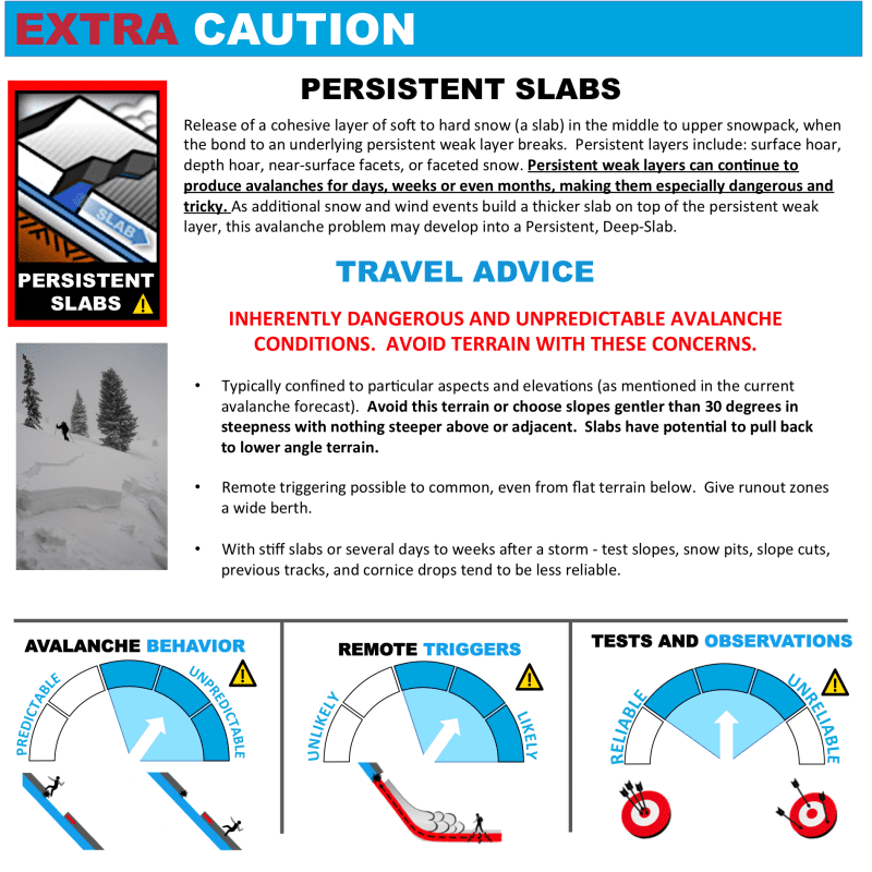
Avalanche Problems
Problem 1
Distribution: Specific — wind loaded slopes. Winds started out of the NW with this storm, and then turned SE, so there will be a lot variability with the loading patterns and any aspect could be wind loaded with new snow. Anywhere this new snow is building up, it will form a wind slab that will be sitting over some very weak old surfaces. Human triggering of these fresh new wind slabs will be likely today on slopes 30 degrees and steeper. Continuing snowfall is slowly increasing the load on recent weak layers. We expect increasing avalanche danger through the weekend.
The potential danger of any given slope will depend on how big it is and how much new snow it is holding. The consequences of a slope (including terrain traps, cliffs, and trees) may be a big factor. In addition, there is the potential for surface slabs to step down to deeper persistent weak layers. See the Persistent Slab section below.
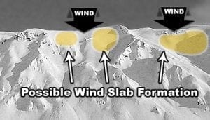
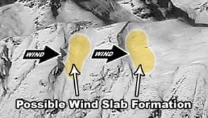
Examples of top loading and cross loading (click image to read more).

Likelihood:
- Almost Certain
- Very Likely
- Likely
- Possible
- Unlikely
Size:
- Historic
- Very Large
- Large
- Small
Trend
- Increasing
- Steady
- Decreasing
Problem 2
Confidence: High. Distribution: Specific to Widespread.
Weak old snow surface conditions will promote a bed surface for new snow to build up on and run over. These now buried persistent weak layers (PWL‘s) include surface hoar, near surface facets and melt-freeze crusts. In other areas, the snowpack above the MLK rain crust (about 45cm deep) has been scoured by wind and cold resulting in sastrugi and hard wind slab. Due to slow, steady new loading from this weekend’s new snowfall and increasing temps, the danger of triggering these mid-pack weak layers is increasing.
Keep an eye out for pregnant, recently wind loaded slopes, or anywhere new snow has formed a cohesive slab, especially below terrain features (see photo in Avalanche Activity section below). Avoid slopes greater than 30 degrees, dig and look for layers to make specific hazard assessments. Remember that variability is high right now, and your snowpit is just a point observation. Pole probing and other quick tests will help you map out wind slabs and potential weak layers under the snow.
New Persistent Layers and Snowfall Timeline
- Feb. 3 – 10cm of very low density snowfall
- Jan. 30-31 – Surface Hoar event, north winds Jan. 30 – Feb. 2
- Jan 29 – 10cm of snowfall
- Jan 26-28 – Surface Hoar event, north winds Jan. 26-27
- Jan. 24 – 10cm of snowfall
- Jan. 20-23 – Surface Hoar event, north winds Jan. 24
Old Persistent Layers
- Jan. 18 – MLK Day Crust/Facets 45-65cm down in elevations up to ~3000′
- Jan. 10 – Melt-freeze crust 10 down 160-180cm in elevations up to ~3000′
- Jan 31 – New-Years Surface Hoar and Near-Surface-Facets interface ~100-150cm down in protected areas near tree-line, steep openings and alpine bowls.
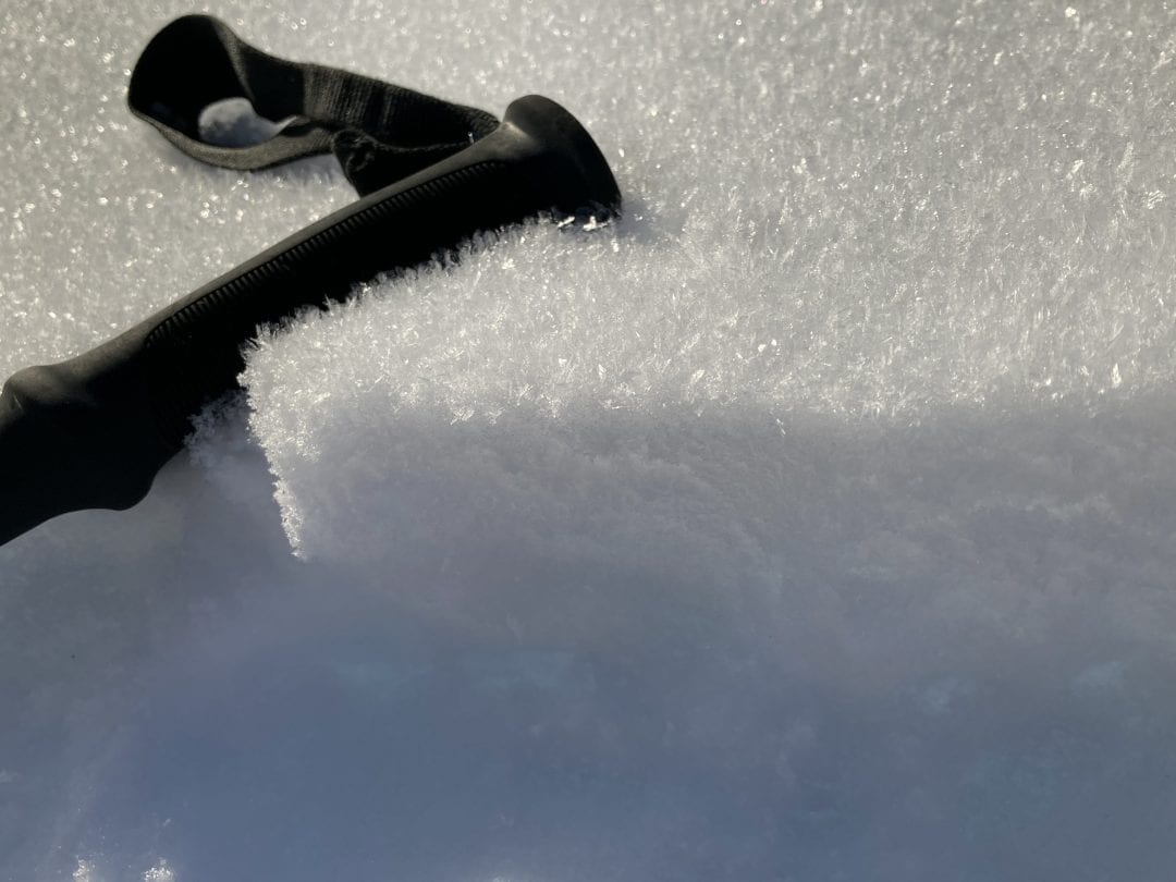
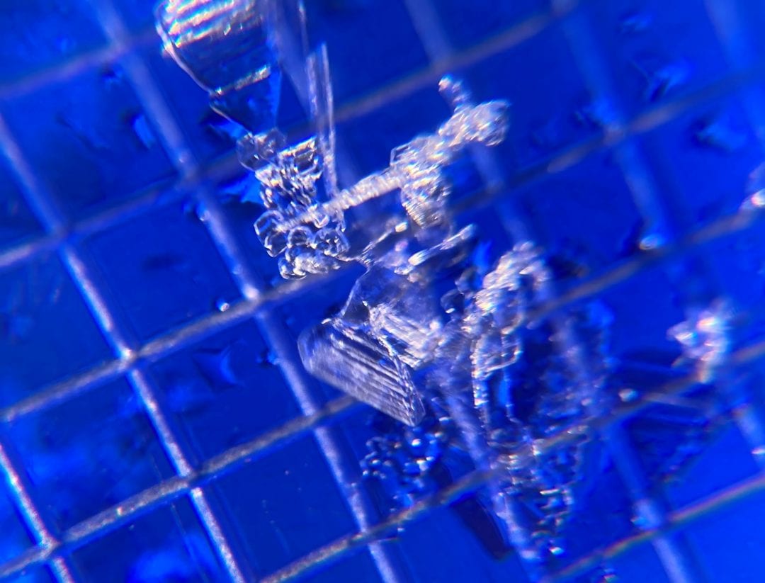
(Surface hoar near-treeline in the Transitional Zone 1/31. Once buried by wind slab or new snow these feathery crystals become a dangerous persistent weak layer that will require extremely careful assessment and overall immediate avoidance in avalanche terrain. Photo: Jeff Moskowitz)

Likelihood:
- Almost Certain
- Very Likely
- Likely
- Possible
- Unlikely
Size:
- Historic
- Very Large
- Large
- Small
Trend
- Increasing
- Steady
- Decreasing
Problem 3

Likelihood:
- Almost Certain
- Very Likely
- Likely
- Possible
- Unlikely
Size:
- Historic
- Very Large
- Large
- Small
Trend
- Increasing
- Steady
- Decreasing
Avalanche Activity
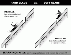
Bottom Line: New snow accumulations, winds and increasing temperatures are creating a heightened risk on avalanche slopes. The most recent snow is slowing building over weak old snow that sat at the surface for multiple weeks now. Cold temperatures that had promoted faceting at the surface, over that time period include surface hoar, near surface facets and melt-freeze crusts. As precip builds over these weak layers and creates a slab, human triggering will become very likely. Avoid steep gullies, ravines and terrain traps at convexity and roll-overs, or anywhere snow could pile up quickly. Hard wind slabs in steep terrain may be difficult to trigger, but large, destructive, and unpredictable. If triggered, they are most likely to release above you.
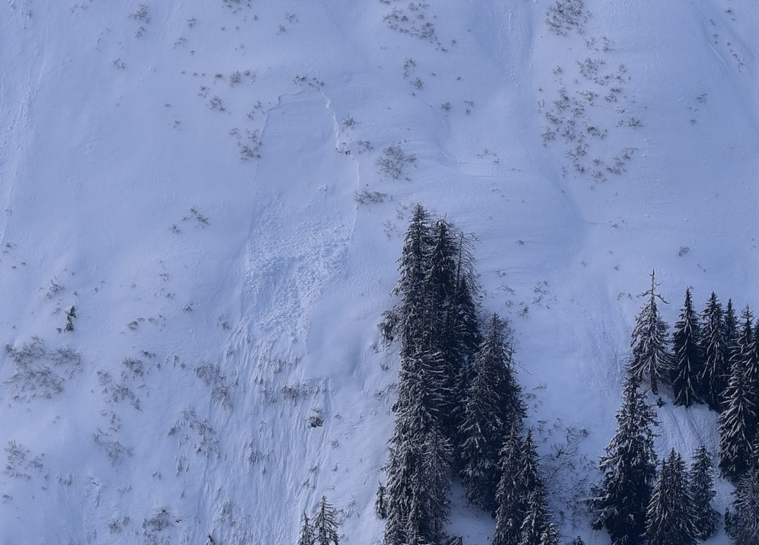
D2 Slab in cross-loaded terrain. Transitional Zone, NE aspect, 1500ft. Photo: Erik Stevens. 2/4/2021
There has been little observed activity in the last two weeks, but this D2 pocket slab from Feb 4 is a good example of wind slabs lurking in cross-loaded pockets. These slabs are sitting on very weak surface hoar or facet layers and will be ripe for human triggering.
Weather
We’re coming out of two weeks of clear, very cold weather with strong NW winds. Friday’s snowfall amounted to 4-10″. An additional 8-12″ fell Saturday Night. For Sunday, South winds will likely blast through again, bringing snow levels up to 1000ft with continuing light precip.
| Snow Depth [in] | Last 24-hr Snow/SWE [in] | Last 3-days Snow/SWE [in] | Today’s Freezing Level [ft] | Today’s Winds | Next 24-hr Snow/SWE | |
| Mount Ripinsky @ treeline | 140″+* | 10″ / 1.00* | 24″ / 2.20* | 0->1000′ | light, var | 4″ / 0.30* |
| Flower Mountain @ treeline | 108″ | 10″ / 1.00 | 21″ / 2.10 | 0->1000′ | light, var | 4″ / 0.30* |
| Chilkat Pass @ 3,100ft | 64″ | 7″ / 0.60 | 15″ / 1.30 | 0->1000′ | light, var | 4″ / 0.30* |
( *star means meteorological estimate )
—The Mt. Ripinsky weather station is completely buried and no longer reporting.—
Additional Information
Practice like you play. Make sure all your rescue gear it is fully functional and your beacon has full batteries. Make sure 1) everyone in the group has a functioning beacon, shovel and probe 2) knows how to use them and 3) has trained in companion rescue in the last year. Keep your skills fresh. If you head into the hills, watch out for red flag avalanche conditions, natural avalanches, whoomphing or collapsing, and shooting cracks.
Education Video Links:
- AIARE
- How to Practice Avalanche Rescue Snowmobile Edition: https://youtu.be/2ML499MMDfM
- AK Sled Shed Motorized Learning:
- Intro: https://youtu.be/aoagKHfGkxs
- Personal Electronics in Avalanche Terrain: https://youtu.be/2Vz9S0OEyFk
- Snowmobile Macgyver Tool Kit: https://youtu.be/4WBNu_t6Bbk
- Head and Face Protection: https://youtu.be/jIzW89wOyZI
- Pre-season prep: https://youtu.be/zJmrb8cZlR4
- My Transceiver: https://youtu.be/yblaDWP7Jf8
- BCA Avalanche Safety for Snowmobilers
- How to Fix Common Snowmobile Problems in the Field: https://youtu.be/g9fiTxEvuFk
- Sleducation: Avalanche Safety for Snowmobilers: https://youtu.be/EWFOd_9DYb8
- Intro to Avalanche Transceivers for Snowmobilers: https://youtu.be/6ZLSBmsceog
- Avalanche Transceiver Trailhead Test for Snowmobilers: https://youtu.be/rWoXbadFBsY
- Avalanche Transceiver Searching Use Snowmobiles: https://youtu.be/w1ucyI6LMXM
- BCA Avalanche Rescue Series
- Beacon Search 101: https://youtu.be/nnHXLVA2FcE
- Avalanche Probing 101: https://youtu.be/-0_yDN5Drzw
- Avalanche Shoveling 101: https://youtu.be/dGQg9o3vAkM
- Organizing a Backcountry Rescue: https://youtu.be/gywtmukgt8s
- Post Avalanche Patient Care: https://youtu.be/9FyIeUy4wpQ
- Backcountry Evacuation: https://youtu.be/WPF-dciefL8
- Complex Multiple Burials Backup Techniques: https://youtu.be/pB6AfY2KyYo
- National Avalanche Center
- Avalanche Problems Explained: https://youtu.be/DkbnT_9-cHU
- Intro to North American Avalanche Danger Scale: https://youtu.be/r_-KpOu7tbA
Announcements
Click the + Full Forecast link below for each zone to read more. Submit observations. Win prizes. Each observation will be entered in a raffle drawing, this month’s prize a 1-hour massage gift certificate from Haines Body Work and Restorative Massage. Submit confidential reports and findings to [email protected].