Valdez
Above 4,000ftConsiderable
2,000 to 4,000ftConsiderable
Below 2,000ftConsiderable
Degrees of Avalanche Danger
Avalanche Problems
Problem 1
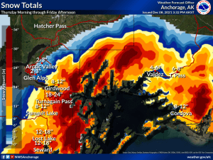
The 12/5-12/6 storm that deposited 2 feet of snow in Valdez and 12-16″ on Thompson Pass, has increased the depth of the slab that is sitting on the November facets. On 12/8 a remote triggered/sympathetic avalanche event (see observation section) is a clear sign that our persistent slab avalanche problem is hanging on by its fingernails. This is especially true in wind sheltered areas. In locations were old wind slabs exist above the November facets, weak layers may be more stubborn to triggers. But the same weak layer exists and dangerous human triggered avalanches are possible in these locations as well.
The next storm is on tap for our area beginning this afternoon with 4-8″ of snowfall and moderate to strong east winds that will eventually turn to northeast. This will further build Persistent slab depths, but will probably not be enough to cause a natural avalanche cycle. As the next storm exits strong northeast winds will turn on. It is possible this will be enough to create some natural avalanche activity on southerly aspects.
The 24 hour rule will not apply for our current setup. The only successful mitigation practices for a persistent slab avalanche problem are patience, and a conservative approach in choosing terrain. Good protocols are very important as well during this type of avalanche problem ie: only exposing one person at a time to an avalanche prone slope, good communication and having an escape route should a slope fail.
Some important things to remember about a persistent weak layer problem is that tracks are not a sign of stability. A slope can fail after many tracks have been laid down. Also it will be possible to trigger avalanches remotely meaning a slope that is above you or adjacent to your position.
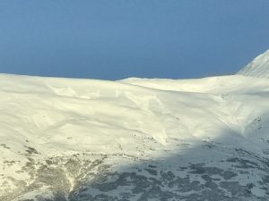
Photo of Remote triggered/sympathetic avalanches on 12/8
1cm+ chained facet found buried 40 cms (16″) on Catchers Mitt 3500′ SE aspect.


Likelihood:
- Almost Certain
- Very Likely
- Likely
- Possible
- Unlikely
Size:
- Historic
- Very Large
- Large
- Small
Trend
- Increasing
- Steady
- Decreasing
Problem 2
East winds are expected to be moderate to strong today as snowfall arrives. As the storm exits winds will ratchet up and move to northeast. Expect to find fresh wind slabs up to 2 feet in depth in wind channeled terrain that will be reactive to human triggers. Wind slab avalanches will have the potential to step down into deeper faceted layers in our snowpack (see problem 1) and produce larger avalanches. Avoid recently wind loaded slopes in terrain steeper than 32°.

Likelihood:
- Almost Certain
- Very Likely
- Likely
- Possible
- Unlikely
Size:
- Historic
- Very Large
- Large
- Small
Trend
- Increasing
- Steady
- Decreasing
Avalanche Activity
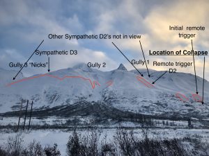
12/8- Large remote trigger/ sympathetic avalanche event occurred 12/8 with avalanches extending from Gully 1 to Nicks. Avalanches were soft slabs that ranged in size from D1-D3. 8 separate avalanches were counted with crown depths averaging 2-3′. One avalanche had a crown length of half a mile while another was triggered over a mile away from the point of collapse. See observation section for full report and more photos.
12/7- Only a few natural avalanches were noted during the last storm. It is likely there were more during the storm, but crowns may have been filled in by subsequent wind and snow.
D2 on Town mountain was observed ~3000′
A couple of D2’s were noted in N. Oddessey gully and Big Oddessey.
D2 on 40.5 mile peak ~5500′.
12/2-12/3- Several natural D2 avalanches were noted on south aspects of Three pigs, Hippie Ridge and Averys. These windslab avalanches originated between 4000-5500 feet elevation.
Weather
NWS Watches and Warnings
None
Point forecast for Thompson Pass
Detailed forecast for Thompson Pass (mid elevation 2000-4000′)
DATE             THURSDAY 12/09          FRIDAY 12/10
TIME (LT)        06    12    18    00    06    12    18    00    06
CLOUD COVER      OV    OV    OV    OV    OV    OV    BK    BK    BK
CLOUD COVER (%)  75   100   100   100    95    85    65    65    65
TEMPERATURE       9    17    14    12    12    18     8     2     4
MAX/MIN TEMP                 18          10          20           0
WIND DIR          E     E     E     E     E    NE    NE    NE     N
WIND (MPH)        8    20    32    17    18    17    18    26    18
WIND GUST (MPH)        40    55    34                39    51
PRECIP PROB (%)  20   100   100   100    90    80    50    30     5
PRECIP TYPE       S     S     S     S     S     S     S     S
12 HOUR QPF                0.14        0.38        0.07        0.04
12 HOUR SNOW                2.2         6.8         1.2         0.0
SNOW LEVEL (KFT)0.0   0.0   0.0   0.0   0.0   0.0   0.0   0.0   0.0
Snow and Temperature Measurements
| Date: 12/09 | 24 hr snow | HN24W* | High Temp | Low Temp | Weekly SWE (Monday- Sunday) | December Snowfall | Season Snowfall | HS (Snowpack depth) |
| Valdez | 0 | 0 | 30 | 9 | 1.48 | 39 | 64 | 32 |
| Thompson Pass | 0 | 0 | 17 | 6 | 1.2 | 26 | 145 | 36 |
| 46 Mile | – | – | – | – | 12 | 12** | 13
|
All snowfall measurements are expressed in inches and temperature in Fahrenheit. 24 hour sample period is from 6am-6am.
* 24 hour snow water equivalent/ SWE.
** Season total snowfall measurements for 46 mile began December 1st.
Season history graphs for Thompson Pass
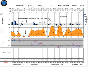
Click on links below to see a clear and expanded view of above Season history graphs
Additional Information
Winter weather began early this season, with valley locations receiving their first snowfall on the last day of Summer (September 21st). Following this storm, above average temperatures and wet weather occurred from late September through early November. During this time period Thompson Pass received 96 inches of snowfall by November 7th and Valdez recorded 7.73″ of rain.
After the 7th of November our region experienced a sharp weather pattern change. Temperatures dropped below seasonal norms and snowfall became infrequent. Between the time frame of November 7th- November 28th Thompson Pass only reported 19″ of snow with 1.1″ of Snow water equivalent (SWE). Temperatures remained below 0° F for most of the period. This cold/dry weather caused significant faceting of the snowpack, with poor structure the result.
Moderate snowfall returned to our area the last day of November and deposited 6-12 inches of new snow. The amount varied depending upon the locations’ proximity to the coast. As the storm exited on the 2nd of December it was quickly replaced by moderate to strong northeast winds.
On 12/5-12/6 Valdez received 2 feet of new snow with Thompson Pass reporting 16″. Blaring red flags like collapsing, shooting cracks and propagation in stability tests were immediately present. This indicates we have moved into persistent slab avalanche territory.
Announcements
Click the + Full Forecast button below for a list of current avalanche problems, travel advice, weather resources and more.
Help to improve your local avalanche center and contribute an observation to the website. You can also contact me directly at [email protected] (907)255-7690.