Haines Avalanche Center
Above 2,500ftConsiderable
1,500 to 2,500ftConsiderable
Below 1,500ftModerate
Degrees of Avalanche Danger
Avalanche Problems
Problem 1
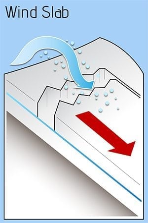
Extreme weather should be concern for extreme avalanche conditions. Near constant precipitation (very heavy at times) and strong southerly winds have plagued the forecast region since the beginning of December. Significant loading near and above treeline have created a series of wind slab unknown in size and predictability. Punchy snow, visible loading and strong over weak layer indicate the presence of these wind slabs that could propagate much larger than expected. A wide margin of safety is necessary for mitigating this avalanche hazard with the extraordinary weather event. Lower run-out zones should also be assessed carefully and avoided while the snowpack has time to adjust.
Likelihood:
- Almost Certain
- Very Likely
- Likely
- Possible
- Unlikely
Size:
- Historic
- Very Large
- Large
- Small
Trend
- Increasing
- Steady
- Decreasing
Problem 2
At the base of the snowpack, depth hoar still exists, and a series of melt-freeze crusts in the mid-pack. On Dec. 2nd freezing levels spiked to 5,000′ and possibly even higher that have undoubtedly created a melt-freeze layer of concern. Any of these crusts can act as a bed surface and a weak interface within the old snow. Heavy new loading above these persistent and deep persistent layers has increased the likelihood of triggering these layers. This will be a problem on all aspects. Be especially cautious of steep, heavily wind-loaded areas near and above treeline, and unsupported slopes. Convexities, where there is a steep rollover, will be a likely place to trigger a deeper slab, or where a initial slide could step-down with high consequences. This kind of danger is tricky and can be hard to manage, so again, a wide safety margin is recommended. Lower run-out zones should also be assessed carefully and avoided while the snowpack has time to adjust.
Likelihood:
- Almost Certain
- Very Likely
- Likely
- Possible
- Unlikely
Size:
- Historic
- Very Large
- Large
- Small
Trend
- Increasing
- Steady
- Decreasing
Avalanche Activity
Our staff has been busy with the emergency. Please send in any observations of avalanche activity, including estimated depth, width, length, and location/elevation. Photos are great too. Beware of unstable land as well. Soil and earth have been inundated with historic amounts of water and may be susceptible to landslides, tree fall and other hazards.
Weather
The weather has been relentless with strong winds, heavy precipitation and above freezing temperatures. Snow levels reached 5,000′ or even higher on Dec. 2nd and appear to be somewhere between 2,000 – 3,000′ currently. Forecasts show precipitation tapering slowly today into tomorrow, as cooler temperatures spread across the region. Storm totals for the atmospheric river event from Dec. 1 are well over 8-10″ of snow water equivalent (SWE).
| Snow Depth [in] | Last 24-hr Snow/SWE [in] | Last 3-days Snow/SWE [in] | Today’s Freezing Level [ft] | Today’s Winds | Next 24-hr Snow/SWE | |
Mount Ripinsky @ treeline |
90″ | ~10″ / 1.00* | ~35″ / 3.50* | 2,000 -> 3,000 | strong, SE | ~1.5″ / 1.50* |
Flower Mountain @ treeline |
62″ | ~5″ / 0.50 | 22″ / 2.50 | 2,000 -> 3,000 | N/A | ~1″ / 1.00* |
Chilkat Pass @ 3,100ft |
13″ | ~6″ / 0.60 | 6″ / 0.60 | 1,000 -> 2,000 | mod, NE | <1″ / 1.00 * |
( *star means meteorological estimate )
Additional Information
It’s time to start thinking avalanche. Dust off your gear and make sure it is fully functional. Put new batteries in your beacons! Do a beacon practice to start the season and keep your skills fresh. If you head into the hills, watch out for avalanche conditions, and be especially careful of rocks and hidden hazards like crevasses beneath the snow. WEAR A HELMET!

Education Video Links:
- AIARE
- How to Practice Avalanche Rescue Snowmobile Edition: https://youtu.be/2ML499MMDfM
- AK Sled Shed Motorized Learning:
- Intro: https://youtu.be/aoagKHfGkxs
- Personal Electronics in Avalanche Terrain: https://youtu.be/2Vz9S0OEyFk
- Snowmobile Macgyver Tool Kit: https://youtu.be/4WBNu_t6Bbk
- Head and Face Protection: https://youtu.be/jIzW89wOyZI
- Pre-season prep: https://youtu.be/zJmrb8cZlR4
- My Transceiver: https://youtu.be/yblaDWP7Jf8
- BCA Avalanche Safety for Snowmobilers
- How to Fix Common Snowmobile Problems in the Field: https://youtu.be/g9fiTxEvuFk
- Sleducation: Avalanche Safety for Snowmobilers: https://youtu.be/EWFOd_9DYb8
- Intro to Avalanche Transceivers for Snowmobilers: https://youtu.be/6ZLSBmsceog
- Avalanche Transceiver Trailhead Test for Snowmobilers: https://youtu.be/rWoXbadFBsY
- Avalanche Transceiver Searching Use Snowmobiles: https://youtu.be/w1ucyI6LMXM
- BCA Avalanche Rescue Series
- Beacon Search 101: https://youtu.be/nnHXLVA2FcE
- Avalanche Probing 101: https://youtu.be/-0_yDN5Drzw
- Avalanche Shoveling 101: https://youtu.be/dGQg9o3vAkM
- Organizing a Backcountry Rescue: https://youtu.be/gywtmukgt8s
- Post Avalanche Patient Care: https://youtu.be/9FyIeUy4wpQ
- Backcountry Evacuation: https://youtu.be/WPF-dciefL8
- Complex Multiple Burials Backup Techniques: https://youtu.be/pB6AfY2KyYo
- National Avalanche Center
- Avalanche Problems Explained: https://youtu.be/DkbnT_9-cHU
- Intro to North American Avalanche Danger Scale: https://youtu.be/r_-KpOu7tbA
Announcements
We have begun periodic conditions updates for winter 2020/2021. Click the + Full Forecast link below for each zone to read more.

