Valdez
Above 4,000ftModerate
2,000 to 4,000ftModerate
Below 2,000ftModerate
Degrees of Avalanche Danger
Avalanche Problems
Problem 1
On 12/1 windslabs showed signs of instability with moderate propagation in snow pits 10-12 inches in depth. Additional signs of instability included a large collapse and shooting cracks on the lee side of terrain features. Northeast winds are forecasted to increase 12/2 with gusts to 40 mph possible. This uptick in winds will increase the depth of wind slabs and sensitivity to human triggers. In most locations these windslabs will overly faceted snow, this will make them more sensitive, and allow them to be reactive longer than normal. Watch for signs of wind slab including: hard snow over soft, shooting cracks, pillowed snow surfaces and a hollow drum like sound. Avoid travel on or below large wind loaded slopes that are steeper than 32° . Avoid traveling in or above terrain traps. It is possible for the hazard to increase through the day if winds become stronger and more widespread than forecasted.

Likelihood:
- Almost Certain
- Very Likely
- Likely
- Possible
- Unlikely
Size:
- Historic
- Very Large
- Large
- Small
Trend
- Increasing
- Steady
- Decreasing
Problem 2
The cold and dry weather in November caused a lot of faceting to occur in the snow, creating a weak snowpack. At this point it is unclear as to how much stress our snowpack will be able to withstand before failing. In protected areas, it is unlikely that the 5-10″ of new snow will be enough to tip the scales naturally. Although, where wind has loaded the new snow into deeper slabs it is possible that avalanches either natural or human triggered could step down to these weak layers creating larger more dangerous avalanches. While early season conditions exist, snowpack structure will vary from place to place. Don’t expect to find the same snow stability across the forecast area. Re-assess the snowpack every time you are traveling to a new location.

Likelihood:
- Almost Certain
- Very Likely
- Likely
- Possible
- Unlikely
Size:
- Historic
- Very Large
- Large
- Small
Trend
- Increasing
- Steady
- Decreasing
Weather
Point forecast for Thompson Pass
Detailed forecast for Thompson Pass (mid elevation 2000-4000′)
DATE             THURSDAY 12/02          FRIDAY 12/03
TIME (LT)        06    12    18    00    06    12    18    00    06
CLOUD COVER      OV    BK    SC    SC    SC    SC    FW    FW    FW
CLOUD COVER (%)  85    65    35    35    40    30    25    25    20
TEMPERATURE       6     3     0    -2    -3    -4    -4    -5    -6
MAX/MIN TEMP                  6          -3          -1          -8
WIND DIR         NE    NE    NE    NE    NE    NE    NE    NE    NE
WIND (MPH)       17    21    24    19    17    13    12    12    14
WIND GUST (MPH)  35    41    41    37    35    40    42    39    36
PRECIP PROB (%)  10    10     5     5     0     5    10    10    10
PRECIP TYPE
12 HOUR QPF                0.00        0.00        0.00        0.00
12 HOUR SNOW                0.0         0.0         0.0         0.0
SNOW LEVEL (KFT)0.0   0.0   0.0   0.0   0.0   0.0   0.0   0.0   0.0
Snow and Temperature Measurements
| Date: 12/02 | 24 hr snow | HN24W* | High Temp | Low Temp | Weekly SWE (Monday- Sunday) | December Snowfall | Season Snowfall | HS (Snowpack depth) |
| Valdez | 4.5 | .24 | 28 | 14 | .54 | 13 | 38 | 22 |
| Thompson Pass | N/O | N/O | 21 | 12 | .5 | 8 | 127 | 30 |
| 46 Mile | 1 | .1 | 15 | 0 | .32 | 5 | 5** | 13
|
All snowfall measurements are expressed in inches and temperature in Fahrenheit. 24 hour sample period is from 6am-6am.
* 24 hour snow water equivalent/ SWE.
** Season total snowfall measurements for 46 mile began December 1st.
Season history graphs for Thompson Pass
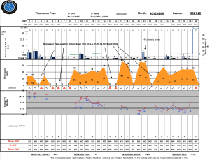
Click on links below to see a clear and expanded view of above Season history graphs
Additional Information
Winter weather began early this season, with valley locations receiving their first snowfall on the last day of Summer (September 21st). Following this storm, above average temperatures and wet weather occurred from late September through early November. During this time period Thompson Pass received 96 inches of snowfall by November 7th and Valdez recorded 7.73″ of rain.
After the 7th of November our region experienced a sharp weather pattern change. Temperatures dropped below seasonal norms and snowfall became infrequent. Between the time frame of November 7th- November 28th Thompson Pass only reported 19″ of snow with 1.1″ of Snow water equivalent (SWE). Temperatures remained below 0° F for most of the period. This cold/dry weather caused significant faceting of the snowpack, with poor structure present as of 11/30 in all three forecast zones.
Announcements
Click the + Full Forecast button below for a list of current avalanche problems, travel advice, weather resources and more.