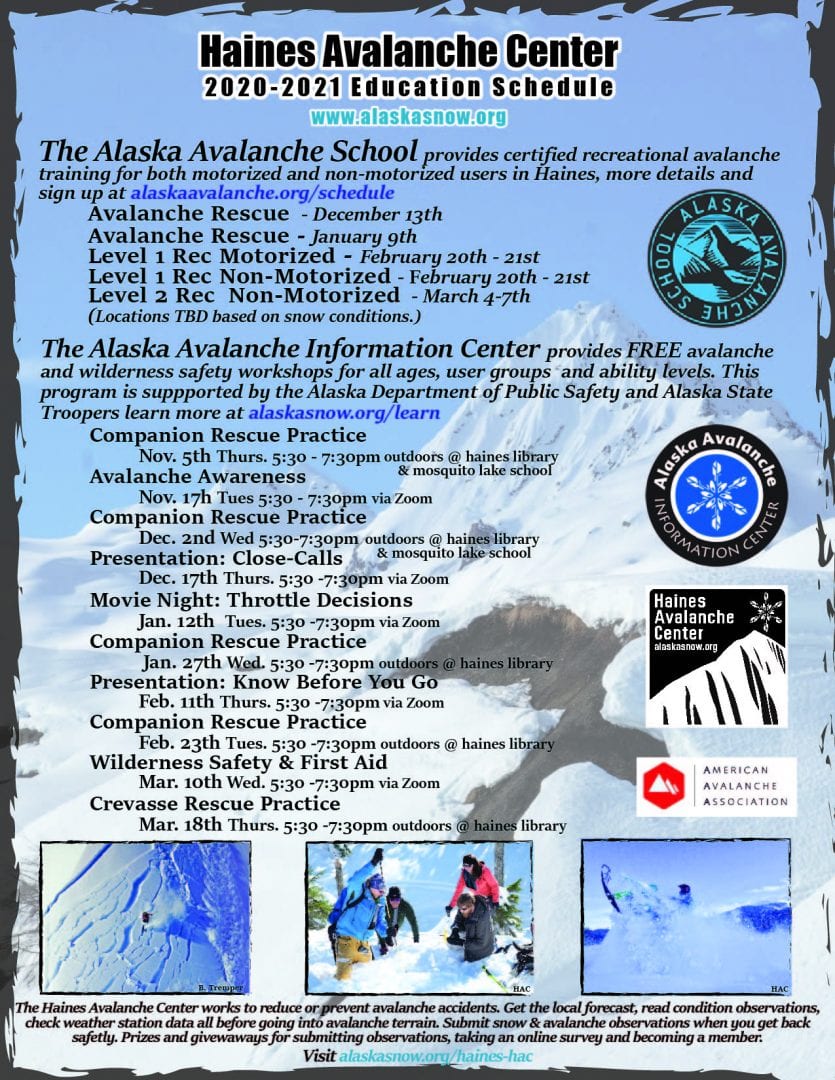
Haines Avalanche Center
Above 2,500ftHigh
1,500 to 2,500ftHigh
Below 1,500ftConsiderable
Degrees of Avalanche Danger
Avalanche Problems
Problem 1
Snowfall totals yesterday were 12-15″ of cold dry light snow transitioning in areas to warmer wetter temperatures and continued precipitation have set up an upside-down snowpack. Increasing temperatures, precipitation (type/amount/rate) and winds (speed/direction) all are important factors contributing to the storm snow problem. Be attentive to this current problem, look for red flag signs of instability, reactive, drifting snow, cracking, whumphing, or natural avalanches. Do quick hand pit shears, get off the main track & use low-consequence test slopes to help make stability assessments.

Likelihood:
- Almost Certain
- Very Likely
- Likely
- Possible
- Unlikely
Size:
- Historic
- Very Large
- Large
- Small
Trend
- Increasing
- Steady
- Decreasing
Problem 2
What we know, both zones up to 3000′ show poor structure (layers in the snow pack that could produce an avalanche) including melt-freeze crusts, buried surface hoar and near surface facets. It is best to assume spatial distribution is widespread until proven otherwise. Cold temperature gradients have weakening effects on these supportive crusts near the surface, close enough to the surface that they are prime for human triggering, especially in thin area near trees, rocks, cliffs and unsupported slopes. Probe the snowpack for this problem and feel for strong over weak layers, or a punchy, hollowness. Keep in mind this problem can be triggered from far distance/not on the slab. Give respect to overhead exposure, look for convexities and identify hazardous terrain traps, or where snow could pile up quickly.
(Click photo to learn more about surface hoar at avalanche.org)

Likelihood:
- Almost Certain
- Very Likely
- Likely
- Possible
- Unlikely
Size:
- Historic
- Very Large
- Large
- Small
Trend
- Increasing
- Steady
- Decreasing
Problem 3
Melt-freeze crusts in the snowpack act as a vapor barrier and are likely to exacerbate the presence of depth hoar and faceting (weakening of layers). Be aware of outliers and more snow/wind/rain/warmer temps adds weight and stress to the layers below. With a series of persistent layers in the mid-pack, the chances of an avalanche stepping-down are within the realm of possibility. Avoid big, open, wide 30° degree steep, exposed, planar, convex, or un-supported slopes, and especially terrain traps (cliffs, trees, rocks, gullies) or areas of drainage, where water could be flowing under the snowpack.

Likelihood:
- Almost Certain
- Very Likely
- Likely
- Possible
- Unlikely
Size:
- Historic
- Very Large
- Large
- Small
Trend
- Increasing
- Steady
- Decreasing
Avalanche Activity
Bottom Line: The snowpack is complicated right now. So are our emotions with the community response to a natural disaster in our home and the taxed EMS resources are exhausted from the immediate and drawn out global pandemic. A range of freezing levels over the past two week & heavy precipitation coupled with variable spatial distribution of surface hoar/near surface facets (weak surface layers now buried) make it moderate to high confidant assessments difficult of what is really going on in the terrain.
Good News: It is still early in the season, a perfect time to self check human factors/decision bias. We need to respect outliers (the unexpected) as it already has been heavy year. Be patient, take breaks, stop and smell the roses, or enjoy the view and company. Stay vigilant about the changing conditions, evaluate the hazards, think risk vs. reward and remember if snow is the problem, terrain is the answer. Choose low consequence slopes and carefully identify terrain traps and areas to avoid.
Weather
Temperatures are increasing from the mid-teens to mid-upper twenties, with rain currently fluctuating near 500 – 1,000′. Various areas are expected to see strong wind, accumulating snow, abundant rainfall, or a combination depending on the location. Wind direction from North to South will likely change snow over to rain, bringing with it warm air to the lower elevations. At the higher elevations and further up the valley, cooler air and a northerly flow points towards increased snowfall accumulation.
| Snow Depth [in] | Last 24-hr Snow/SWE [in] | Last 3-days Snow/SWE [in] | Today’s Freezing Level [ft] | Today’s Winds | Next 24-hr Snow/SWE | |
| Mount Ripinsky @ treeline | 72″ | 10″ / 1.00* | 20″+ / 2.00+* | 500′ – 1,000′ | Moderate, S mixed with N | 8″ / 0.08* |
| Flower Mountain @ treeline | 60″ | 4″ / 0.04* | 5″+ / 0.05+* | 500′ – 1,000′ | N/A | 6″ / 0.06* |
| Chilkat Pass @ 3,100ft | 30″ | 8″ / 0.08* | 8″ +/ 0.08+* | 500′ – 1,000′ | Moderate, N | 5″ / 0.05* |
( *star means meteorological estimate )
Additional Information
It’s time to start thinking avalanche. Dust off your gear and make sure it is fully functional. Put new batteries in your beacons! Do a beacon practice to start the season and keep your skills fresh. If you head into the hills, watch out for avalanche conditions, and be especially careful of rocks and hidden hazards like crevasses beneath the snow. WEAR A HELMET!
Education Video Links:
- AIARE
- How to Practice Avalanche Rescue Snowmobile Edition: https://youtu.be/2ML499MMDfM
- AK Sled Shed Motorized Learning:
- Intro: https://youtu.be/aoagKHfGkxs
- Personal Electronics in Avalanche Terrain: https://youtu.be/2Vz9S0OEyFk
- Snowmobile Macgyver Tool Kit: https://youtu.be/4WBNu_t6Bbk
- Head and Face Protection: https://youtu.be/jIzW89wOyZI
- Pre-season prep: https://youtu.be/zJmrb8cZlR4
- My Transceiver: https://youtu.be/yblaDWP7Jf8
- BCA Avalanche Safety for Snowmobilers
- How to Fix Common Snowmobile Problems in the Field: https://youtu.be/g9fiTxEvuFk
- Sleducation: Avalanche Safety for Snowmobilers: https://youtu.be/EWFOd_9DYb8
- Intro to Avalanche Transceivers for Snowmobilers: https://youtu.be/6ZLSBmsceog
- Avalanche Transceiver Trailhead Test for Snowmobilers: https://youtu.be/rWoXbadFBsY
- Avalanche Transceiver Searching Use Snowmobiles: https://youtu.be/w1ucyI6LMXM
- BCA Avalanche Rescue Series
- Beacon Search 101: https://youtu.be/nnHXLVA2FcE
- Avalanche Probing 101: https://youtu.be/-0_yDN5Drzw
- Avalanche Shoveling 101: https://youtu.be/dGQg9o3vAkM
- Organizing a Backcountry Rescue: https://youtu.be/gywtmukgt8s
- Post Avalanche Patient Care: https://youtu.be/9FyIeUy4wpQ
- Backcountry Evacuation: https://youtu.be/WPF-dciefL8
- Complex Multiple Burials Backup Techniques: https://youtu.be/pB6AfY2KyYo
- National Avalanche Center
- Avalanche Problems Explained: https://youtu.be/DkbnT_9-cHU
- Intro to North American Avalanche Danger Scale: https://youtu.be/r_-KpOu7tbA
Alerts
NEW forecast for both the Transitional and Lutak Zones. Winter Weather Advisory remains in effect until 6pm Sunday. Get the forecast before heading out and submit an observation when you get home safely. Beware of roof avalanches which can be fatal.
Announcements
We have begun conditions updates for winter 2020/2021. Click the + Full Forecast link below for each zone to read more.