Haines Avalanche Center
Above 2,500ftModerate
1,500 to 2,500ftModerate
Below 1,500ftModerate
Degrees of Avalanche Danger
Avalanche Problems
Problem 1
Confidence : Medium. Distribution: NE-N-NW aspects, and cross loaded terrain on other aspects. Strong SE winds during the strong storm on Monday caused heavy wind loading on lee aspects, and built alpine wind slabs in starting zones, gullies, and terrain features. These slabs will have high variability in the alpine, and may be quite thick. Human-triggering is possible, especially on slopes 35-degrees and steeper. Pole probing will help you identify and avoid slabby or hollow-feeling areas where there is a wind slab over softer snow. Test slopes will be helpful, but expect each slope to be different. Wind slabs will likely run on/above the MLK rain crust, which sits about 30cm deep in the alpine. On high, heavily wind-loaded slopes, pockets of CONSIDERABLE danger will remain.

Likelihood:
- Almost Certain
- Very Likely
- Likely
- Possible
- Unlikely
Size:
- Historic
- Very Large
- Large
- Small
Trend
- Increasing
- Steady
- Decreasing
Problem 2
Confidence: Low. Distribution: Isolated to Widespread. We have two deep persistent weak layers:
- Melt-freeze crust from 1/10 down 160-180cm in elevations up to ~3000′
- New-Years Surface Hoar and Near-Surface-Facets interface ~100-150cm down in protected areas near tree-line, steep openings and alpine bowls.
We have not seen these persistent layers to be particularly active in the last day or two, but heavy triggers like cornice fall or snowmachine drops could possibly trigger these deep layers (as we saw Monday during the last storm). These weak layers are tricky and could produce large, deadly avalanches, especially in steep terrain, rollovers, and wind loaded areas. If an avalanche were to break this large, expect very wide propagation, where safe zones can easily be entrained in a slab. Be especially careful about trusting your safe zones.
 (Surface hoar near-treeline in the Transitional Zone 12/31. Once buried by wind slab or new snow these feathery crystals become a dangerous persistent weak layer that will require extremely careful assessment and overall immediate avoidance in avalanche terrain. Photo: Tim Thomas)

Likelihood:
- Almost Certain
- Very Likely
- Likely
- Possible
- Unlikely
Size:
- Historic
- Very Large
- Large
- Small
Trend
- Increasing
- Steady
- Decreasing
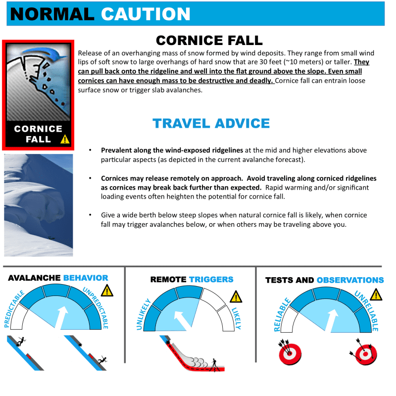
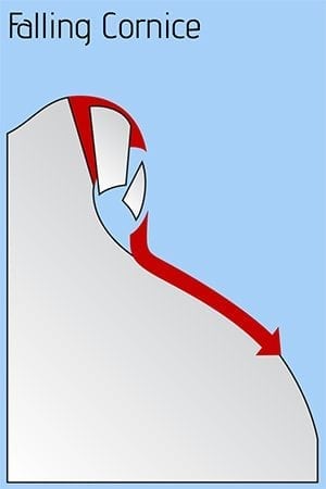
Problem 3
This month’s new snow fell mainly during periods of southeast winds. Monster cornices and snow ledges have built up on peaks and ridgelines. NE-N-NW aspects have the biggest cornices, but they may exist on other aspects as well. Stay way back from corniced ridges! They are likely to break much farther back than expected.
Likelihood:
- Almost Certain
- Very Likely
- Likely
- Possible
- Unlikely
Size:
- Historic
- Very Large
- Large
- Small
Trend
- Increasing
- Steady
- Decreasing
Avalanche Activity
We had a natural avalanche cycle on Jan 17th-18th, when temperatures warmed and rain fell up to 3000ft. A wet slide crossed the Haines highway at 21-mile, and other paths in the backcountry ran as well. Later on the 18th, temperatures dropped and 18-24″ of snow fell down to 2000ft. A smaller cycle ran within this new snow above the MLK-day rain crust. Most slides were 30-60cm deep (D2.5), but at least three slides ran deeper (perhaps down to the New Year’s Surface hoar layer 1.5m deep) with wider propagation (D3, N aspect). These deeper slides appear to been caused by cornice failures/heavy triggers.
Weather
About 2.5″ of precipitation fell last weekend, starting as rain up to 3000ft, then turning to snow down to 2000ft. About 18-24″ of snow fell over the rain crust on Monday. Since then, temperatures have been dropping and winds calm with clearing skies. Surface hoar formed Thursday-Friday. For Saturday, a weak storm will bring 1-4″ of new snow. Clearing is expected on Sunday. The Mt. Ripinsky weather station is completely buried and no longer reporting snow depth.
| Snow Depth [in] | Last 24-hr Snow/SWE [in] | Last 3-days Snow/SWE [in] | Today’s Freezing Level [ft] | Today’s Winds | Next 24-hr Snow/SWE | |
| Mount Ripinsky @ treeline | 135″+* | 0″ / 0.00* | 0″ / 0.00* | 0′ | light, var | 3″ / 0.30* |
| Flower Mountain @ treeline | 109″ | 0″ / 0.00 | 0″ / 0.00 | 0′ | light, var | 2″ / 0.20* |
| Chilkat Pass @ 3,100ft | 74″ | 0″ / 0.00 | 0″ / 0.00 | 0′ | light, var | 1″ / 0.10* |
( *star means meteorological estimate )
Additional Information
Practice like you play. Dust off your gear and make sure it is fully functional. Put new batteries in your beacons! Make sure everyone in the group has a functioning beacon, shovel and probe – and knows how to use them, keep your skills fresh. If you head into the hills, watch out for red flag avalanche conditions, natural avalanches, whumphing or collapsing, and shooting cracks.
Education Video Links:
- AIARE
- How to Practice Avalanche Rescue Snowmobile Edition: https://youtu.be/2ML499MMDfM
- AK Sled Shed Motorized Learning:
- Intro: https://youtu.be/aoagKHfGkxs
- Personal Electronics in Avalanche Terrain: https://youtu.be/2Vz9S0OEyFk
- Snowmobile Macgyver Tool Kit: https://youtu.be/4WBNu_t6Bbk
- Head and Face Protection: https://youtu.be/jIzW89wOyZI
- Pre-season prep: https://youtu.be/zJmrb8cZlR4
- My Transceiver: https://youtu.be/yblaDWP7Jf8
- BCA Avalanche Safety for Snowmobilers
- How to Fix Common Snowmobile Problems in the Field: https://youtu.be/g9fiTxEvuFk
- Sleducation: Avalanche Safety for Snowmobilers: https://youtu.be/EWFOd_9DYb8
- Intro to Avalanche Transceivers for Snowmobilers: https://youtu.be/6ZLSBmsceog
- Avalanche Transceiver Trailhead Test for Snowmobilers: https://youtu.be/rWoXbadFBsY
- Avalanche Transceiver Searching Use Snowmobiles: https://youtu.be/w1ucyI6LMXM
- BCA Avalanche Rescue Series
- Beacon Search 101: https://youtu.be/nnHXLVA2FcE
- Avalanche Probing 101: https://youtu.be/-0_yDN5Drzw
- Avalanche Shoveling 101: https://youtu.be/dGQg9o3vAkM
- Organizing a Backcountry Rescue: https://youtu.be/gywtmukgt8s
- Post Avalanche Patient Care: https://youtu.be/9FyIeUy4wpQ
- Backcountry Evacuation: https://youtu.be/WPF-dciefL8
- Complex Multiple Burials Backup Techniques: https://youtu.be/pB6AfY2KyYo
- National Avalanche Center
- Avalanche Problems Explained: https://youtu.be/DkbnT_9-cHU
- Intro to North American Avalanche Danger Scale: https://youtu.be/r_-KpOu7tbA
Announcements
Click the + Full Forecast link below for each zone to read more. Submit observations. Win prizes. Each snow, weather & avalanche observation will be entered in a raffle drawing. Submit confidential reports and findings to [email protected].