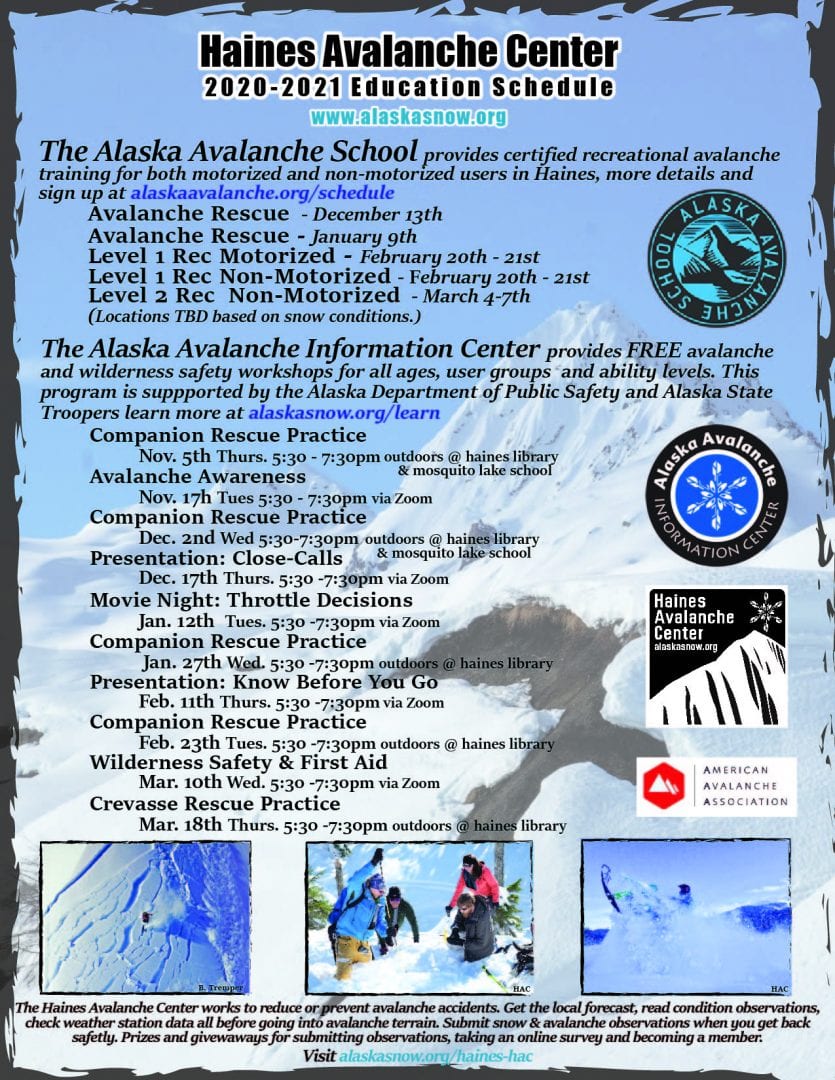
Haines Avalanche Center
Above 2,500ftHigh
1,500 to 2,500ftHigh
Below 1,500ftHigh
Degrees of Avalanche Danger
Avalanche Problems
Problem 1
Confidence : High Distribution: Widespread. Today’s new snow will be adding 1-2″+ of SWE to the upper snowpack that started cold and will end warm, an up-side down setup. This will be adding stress to any buried persistent weak layers further down. There will also likely be weak interfaces within the new storm snow. Natural and human-triggered avalanches are likely today. Avoid terrain 28-degrees and steeper. This is a bad day to venture into avalanche terrain. Smaller slides could step down to deeper weak layers, causing wide propagation.

Likelihood:
- Almost Certain
- Very Likely
- Likely
- Possible
- Unlikely
Size:
- Historic
- Very Large
- Large
- Small
Trend
- Increasing
- Steady
- Decreasing
Problem 2
Confidence: Moderate to High. Distribution: Isolated to Widespread. We have two primary layers of concern:
- Melt-freeze crust from 1/10 down 60-80cm in elevations up to ~3000′
- New-Years Surface Hoar and Near-Surface-Facets interface about 100-120cm down in protected areas near tree-line, steep openings and alpine bowls.
Observations are limited. It is uncertain how these layers will react to the new load. These weak layers are tricky and could produce large avalanches with recent rapid loading of the new snow, especially in steep terrain, rollovers, and wind loaded areas. Today’s new snowfall, rain on snow, and strong south winds are adding a lot of stress to these deeper weak layers, creating a dangerous situation.
 (Surface hoar near-treeline in the Transitional Zone 12/31. Once buried by wind slab or new snow these feathery crystals become a dangerous persistent weak layer that will require extremely careful assessment and overall immediate avoidance in avalanche terrain. Photo: Tim Thomas)

Likelihood:
- Almost Certain
- Very Likely
- Likely
- Possible
- Unlikely
Size:
- Historic
- Very Large
- Large
- Small
Trend
- Increasing
- Steady
- Decreasing
Avalanche Activity
Bottom Line: 1-2′ of new snow at higher elevation and closer to the Canadian border, with moderate to strong southeast winds and increasing temperatures in the forecast. Near sea-level above freezing temperatures and rain. Recent snow sits over a melt-freeze crust down 60-80cm formed briefly 1/10 as temperatures spiked. Below that down 100-120cm in areas are the New-Years surface hoar and/or facets. Elevations below 2500′ expect snow on the ground to become saturated with wet avalanches likely.
Avoid avalanche terrain today. Even small slides can kill, especially when they run into terrain traps. In times of high danger, route-finding skills are essential. Be careful not to expose your group to steep openings, even if they are small.
Weather
Heavy precipitation, snow mixing with rain, strong winds, and increasing temperatures are the mix today and into the weekend, as a storm force low continues to pass over the region. Overnight 1.7″ of precipitation has been reported at 2510′ on Flower Mountain SNOTEL with roughly 16-24″ of new snow accumulation up the highway. Another low pressure system will move northward Saturday.
| Snow Depth [in] | Last 24-hr Snow/SWE [in] | Last 3-days Snow/SWE [in] | Today’s Freezing Level [ft] | Today’s Winds | Next 24-hr Snow/SWE | |
| Mount Ripinsky @ treeline | 135″+* | N/O | N/O | 0 – 1500’+ | moderate to strong, SE | 8″ / 0.80* |
| Flower Mountain @ treeline | 111″ | 17″ / 1.70 | 17″ / 2.50 | 0 – 1500’+ | moderate to strong, SE | 10″ / 1.00* |
| Chilkat Pass @ 3,100ft | 70″ | 12″ / 1.20 | 12″ / 1.00 | 0-1500’+ | moderate to strong, SE | 4″ / 0.4* |
( *star means meteorological estimate )
Additional Information
Practice like you play. Dust off your gear and make sure it is fully functional. Put new batteries in your beacons! Make sure everyone in the group has a functioning beacon, shovel and probe – and knows how to use them, keep your skills fresh. If you head into the hills, watch out for red flag avalanche conditions, natural avalanches, whumphing or collapsing, and shooting cracks.
Education Video Links:
- AIARE
- How to Practice Avalanche Rescue Snowmobile Edition: https://youtu.be/2ML499MMDfM
- AK Sled Shed Motorized Learning:
- Intro: https://youtu.be/aoagKHfGkxs
- Personal Electronics in Avalanche Terrain: https://youtu.be/2Vz9S0OEyFk
- Snowmobile Macgyver Tool Kit: https://youtu.be/4WBNu_t6Bbk
- Head and Face Protection: https://youtu.be/jIzW89wOyZI
- Pre-season prep: https://youtu.be/zJmrb8cZlR4
- My Transceiver: https://youtu.be/yblaDWP7Jf8
- BCA Avalanche Safety for Snowmobilers
- How to Fix Common Snowmobile Problems in the Field: https://youtu.be/g9fiTxEvuFk
- Sleducation: Avalanche Safety for Snowmobilers: https://youtu.be/EWFOd_9DYb8
- Intro to Avalanche Transceivers for Snowmobilers: https://youtu.be/6ZLSBmsceog
- Avalanche Transceiver Trailhead Test for Snowmobilers: https://youtu.be/rWoXbadFBsY
- Avalanche Transceiver Searching Use Snowmobiles: https://youtu.be/w1ucyI6LMXM
- BCA Avalanche Rescue Series
- Beacon Search 101: https://youtu.be/nnHXLVA2FcE
- Avalanche Probing 101: https://youtu.be/-0_yDN5Drzw
- Avalanche Shoveling 101: https://youtu.be/dGQg9o3vAkM
- Organizing a Backcountry Rescue: https://youtu.be/gywtmukgt8s
- Post Avalanche Patient Care: https://youtu.be/9FyIeUy4wpQ
- Backcountry Evacuation: https://youtu.be/WPF-dciefL8
- Complex Multiple Burials Backup Techniques: https://youtu.be/pB6AfY2KyYo
- National Avalanche Center
- Avalanche Problems Explained: https://youtu.be/DkbnT_9-cHU
- Intro to North American Avalanche Danger Scale: https://youtu.be/r_-KpOu7tbA
Announcements
Click the + Full Forecast link below for each zone to read more. Submit observations. Win prizes. Each snow, weather & avalanche observation will be entered in a raffle drawing. Submit confidential reports and findings to [email protected].