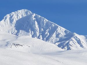
Valdez
Above 4,000ftConsiderable
2,000 to 4,000ftConsiderable
Below 2,000ftModerate
Degrees of Avalanche Danger
Avalanche Problems
Problem 1
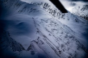
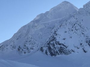
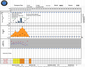
The 3/21 outflow wind event came in stronger than forecasted with wind gusts up to 76 mph reported on Thompson Pass. The strongest winds occurred in the typical locations, with more protected locations seeing moderate winds of 20-30 mph. On 3/21-22 reactive wind slabs were reported with shooting cracks and human triggered avalanches in convex and cross loaded terrain. As time moves forward wind slabs will settle and become stiffer. This will make them more stubborn to human triggers, but if initiated have the potential to have wider propagations and fail behind a skier or snowmachine.
Investigate the depth and sensitivity of windslabs in the area you choose to travel using test slopes. Watch for signs of instability such as shooting cracks and recent avalanche activity. Winds are forecasted to switch to southeast with 6-10 inches expected over the next 48 hours. The avalanche hazard will be lower in areas that have been unaffected by recent winds.

Likelihood:
- Almost Certain
- Very Likely
- Likely
- Possible
- Unlikely
Size:
- Historic
- Very Large
- Large
- Small
Trend
- Increasing
- Steady
- Decreasing
Problem 2
In some places there is surface hoar 1.5-2.5 feet deep in our snowpack. This layer has produced numerous human triggered avalanches during the 3/6-7 time period. Recently the sensitivity of this layer has decreased and become unreactive. At this point triggering an avalanche at this interface is unlikely. It is still possible to identify this layer in snow pits, although no significant results have been observed or reported lately and the layer has been found to be laid over.
The best way to identify if this layer is a concern in the area where you are traveling, will be to dig snow pits to see if this layer remains intact. This assessment can be difficult as the distribution of the 3/3 BSH is spotty at this point. Assessment is recommended on a slope to slope basis.
This layer has been found to exist on northerly aspects between the elevations of 3-6000 feet and be 1-2 feet deep. Recent warm temperatures have caused surface hoar to round (heal) below 3000′. The most likely area to encounter this problem on the road corridor would be north of Thompson Pass on the south side of the road.

Likelihood:
- Almost Certain
- Very Likely
- Likely
- Possible
- Unlikely
Size:
- Historic
- Very Large
- Large
- Small
Trend
- Increasing
- Steady
- Decreasing
Problem 3
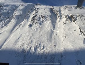
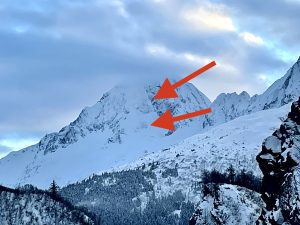
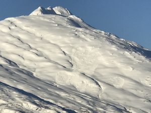
D3 hard slab avalanche on Billy Mitchell ~4000’/ North aspect that occured on 2/18
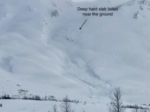
Weak faceted snow (November facets) exists at the base of our snowpack. Full profile snow pits as recently as 3/11, have continued to show poor structure in our lower snowpack although stability results have become stubborn. This layer will be difficult to affect because it is so deep, however with the poor structure of the snowpack, the risk remains.
This is a low probability very high consequence situation. This variety of avalanche problem is very difficult to asses and impossible to manage if initiated. This variety of avalanche will not fail at your feet, but rather once you are well onto the slab, skiing or riding off a slab of this size would be extremely unlikely. This issue should be in the back of our minds when we choose terrain. We can avoid a lot of risk by avoiding steep, rocky or complex terrain and avoiding steep slopes in the Continental region. These are the places where trigger points will exist closer to the surface.
Natural activity at this layer has been very limited lately, although one deep slab on a south aspect around 5000′ was observed on 3/20. This variety of avalanche problem has the potential to re-awaken with sudden changes in weather. An example would be direct sun heating up solar aspects. Steep and rocky southerly aspects will be a concern as the sun gets higher and we begin to have more sunny days.

Likelihood:
- Almost Certain
- Very Likely
- Likely
- Possible
- Unlikely
Size:
- Historic
- Very Large
- Large
- Small
Trend
- Increasing
- Steady
- Decreasing
Avalanche Activity
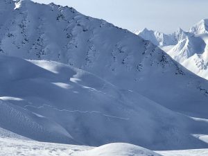
3/22- Skier triggered D2 windslab avalanche on a west aspect near schoolbus.
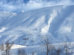
3/21- Numerous natural D1 windslab pockets reported releasing from W-N-E mid and low elevation convexities.
3/19- Fresh D1 natural windslab just east of Nicks, north aspect.
3/18- Ski cuts have been reported as productive at the new/old interface from 3/15. These have been small and in the 6-8 inches deep.
3/7- More skier triggered avalanches, mostly D1-D2’s failing at the 3/3 BSH.
A local snowmachiner that was traveling through Marshall Pass reported a very notable natural deep hard slab that failed at the November facets. Avalanche occured on a North aspect between the Schwan and Woodworth glaciers failed at the ground and ran into the Tasnuna river valley. Avalanche was estimated as D3-D4 with a crown depth over 10 feet.
Another deep hard slab released naturaly on a high south aspect ~5500′ behind Averys.
3/6- Numerous skier triggered D1-D2 avalanches occured failing at the new snow/old snow interface on surface hoar buried 3/3. Ski cuts were reported to be very productive with sensitivity ranging from touchy to very touchy. Most of these avalanches occured further back from the road corridor. Although, one notable skier triggers D2.5 occured on Cracked Ice on a north aspect at ~4000′ that appeared to be 1000 + feet wide. D1 naturals occured on 40.5 mile.
3/5- Numerous D1-D2 natural avalanches occured within the storms now 1-2 feet deep. These occured mostly on northern half of the compass. Including Little and big oddesssey, Gully 1, Mt Dimond moraine and Iguana Backs. A couple of slides were also noted on the southern half of the compass D2.5’s on Hippie ridge and Three Pigs.
2/28- Numerous wet loose running at low elevations with some reported gauging to the ground above town.
2/23- Full depth hard slab avalanche in steep rocky terrain. East facing side of RFS draining into Cascade Creek.
HS-N-R2-D2-O/G Steep Camp Couloir 2
Rhinestone Cowboy-
2/17-18- A Significant avalanche cycle occurred during this time period. Most of the activity failed on deep persistent weak layers. These were the 1/24 facet-crust combo and the November facets. Numerous hard slab avalanches were observed that failed near the ground.
Deep hard slab activity included: Billy Mitchell, Happiness, 40.5 Mile Peak, NE Crudbusters Multiple spots around the Tonsina Glacier, West side of Iguana backs (really wrong place), Multiple spots in the Tsaina valley, Girl Mountain, Cracked Ice, Python, Buttress west of Nicks (this is has slid multiple times this year), North Oddessey shoulder. This is only a portion of the activity that occured.
Most of the activity occured around 4000′, although there were outliers at upper elevations.
Billy Mitchell
Iguana Backs (Really Wrong Place)
Girls
Python
Cracked Ice
Tonsina Glacier
North Oddessey Shoulder
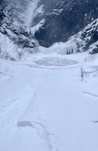
2/17 – Keystone Canyon was reported to have many size 1-2 loose avalanches on the steep canyon walls. Crowns with depths of 10-15″ have been reported as well on the ice climbs Simple twist, Bridal Veil and Green Steps. Photo approach to Simple Twist
2/15- A large deep persistent avalanche occurred on “Back It In” near Mt Dimond. The trigger is unknown, but was most likely triggered remotely by a helicopter landing on a recon mission. It appears that a cornice fall triggered a shallow slab over rocks which then stepped down creating a deep slab ~500 feet wide that entrained the entire snowpack. Several other deep slabs failed sympathetically below.
2/13 – Meteorite ramp was reported to have released full path failing at the bedrock.
2/9 & 2/10- Numerous natural avalanches occurred during this time period.
Mt tiekel (50 mile) and 38 mile ran naturally, with 38 mile depositing a small amount of debris on the road.
The entire Python Buttress failed naturally close to the ground with a crown line approximately 1/4 mile in length. Numerous avalanches in the gully to the east occured as well. Debris from both areas extended ~200 meters across flat terrain.
Gully 2 and Nicks had significant slides run into their fans.
Snowslide Gulch ran naturally and hit the road.
DOT mitigation efforts produced activity at Three Pigs and Snowslide Gulch.
Natural activity was more extensive than noted. Snowfall continued after the event refilling crowns and preventing a good look at the extent of natural activity.
1/30-Several natural persistent slab avalanches were observed in the intermountain and continental zone.
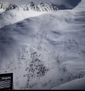
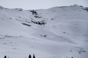
- Remote snowmachine triggered avalanche on Little Girls/ SE aspect/~3500′. Member of group reported that 2 members of a larger party were waiting on the lower angle ridges (bro bowl up route) below the slide pictured waiting for the rest of a larger group. Rider 2 went to play on a small hill nearby when rider 1 felt a large collapse and the slides pictured came down. The rest of the group gathered up and about 5 minutes after the remote trigger felt an earthshaking collapse that had alders swaying and group reported the feeling of dropping/settling a vertical foot. A noise that was described as a bomb quickly followed. The group left the area immediately and did not observe any further avalanche activity caused by the collapse. Other collapses were noted later in the day.
Weather
NWS Watches and Warnings
NONE


Point forecast for Thompson Pass
DATE             WEDNESDAY 03/23         THURSDAY 03/24
TIME (LT)        06    12    18    00    06    12    18    00    06
CLOUD COVER      OV    OV    OV    OV    OV    OV    OV    OV    OV
CLOUD COVER (%) 100   100    95    90    80    80    90    95    95
TEMPERATURE      15    25    25    22    20    29    29    26    24
MAX/MIN TEMP                 28          18          31          23
WIND DIR         NE    SE    SE    SE     E    NE     E     E     E
WIND (MPH)       17    14    16    16    13    20    19    21    23
WIND GUST (MPH)  65                34          47    44
PRECIP PROB (%) 100   100   100   100    80    70    80    80    70
PRECIP TYPE       S     S     S     S     S     S     S     S     S
12 HOUR QPF                0.17        0.21        0.14        0.37
12 HOUR SNOW                2.6         2.8         1.3         3.9
SNOW LEVEL (KFT)0.0   0.0   0.0   0.1   0.1   0.1   0.4   0.2   0.3
Snow and Temperature Measurements
| Date: 03/23 | 24 hr snow | HN24W* | High Temp | Low Temp | Weekly SWE (Monday- Sunday) | March Snowfall | Season Snowfall | HS (Snowpack depth) |
| Valdez | 0 | 0 | 35 | 27 | N/O | 32 | 279 | 79 |
| Thompson Pass | 0 | 0 | 19 | 12 | 0 | 37 | 417 | 67 |
| 46 Mile | 0 | 0 | 32 | 12 | 0 | 10 | 131** | 41
|
All snowfall measurements are expressed in inches and temperature in Fahrenheit. 24 hour sample period is from 6am-6am.
* 24 hour snow water equivalent/ SWE.
** Season total snowfall measurements for 46 mile began December 1st.
Season history graphs for Thompson Pass
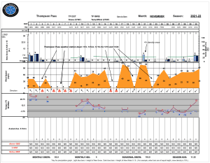
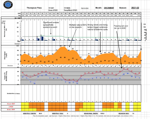
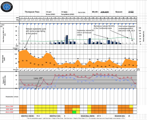
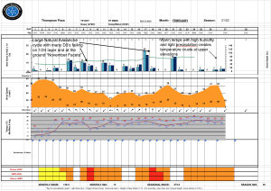
Click on links below to see a clear and expanded view of above Season history graphs
Additional Information
Winter weather began early this season, with valley locations receiving their first snowfall on the last day of Summer (September 21st). Following this storm, above average temperatures and wet weather occurred from late September through early November. During this time period Thompson Pass received 96 inches of snowfall by November 7th and Valdez recorded 7.73″ of rain.
After the 7th of November our region experienced a sharp weather pattern change. Temperatures dropped below seasonal norms and snowfall became infrequent. Between the time frame of November 7th- November 28th Thompson Pass only reported 19″ of snow with 1.1″ of Snow water equivalent (SWE). Temperatures remained below 0° F for most of the period. This cold/dry weather caused significant faceting of the snowpack, with poor structure the result.
Moderate snowfall returned to our area the last day of November and deposited 6-12 inches of new snow. The amount varied depending upon the locations’ proximity to the coast. As the storm exited on the 2nd of December it was quickly replaced by moderate to strong northeast winds.
On 12/5-12/6 Valdez received 2 feet of new snow with Thompson Pass reporting 16″. Blaring red flags like collapsing, shooting cracks and propagation in stability tests were immediately present. On 12/8 a significant remote/ sympathetic avalanche event occurred from Gully 1 through Nick’s Happy Valley.
Strong outflow winds began on 12/11 with periods of light snowfall. This has caused slab thicknesses to become variable in areas exposed to NE winds.
A fair amount of natural avalanche activity occurred during the 12/11 wind event mostly on southerly aspects. The week following this wind event fairly benign weather occurred which allowed the snowpack to adjust and for stability to improve although snowpack structure has remained poor.
On 12/21 our area received a couple inches of snow along with temperatures rising and strong outflow winds. This combination of weather kicked off a fairly significant natural avalanche cycle. Many of the slabs appeared to be deeper wind slabs that were created from the 12/11 wind event. These failed on faceted snow created in November. The event is yet another indicator of our poor snowpack structure and its inability to receive any major change in weather without the avalanche hazard rising in conjunction.
On 12/26-28 warm air moved in at elevation and caused light rain to fall up to ~4000′. A very thin rain crust was formed in many locations that was unable to support a persons weight.
A prolonged period of strong north winds began on new years day with wind speeds reaching 80 mph. As winds tapered to 30-40 mph on the 5th temperatures plummeted with lows exceeding -30 F in the Tsaina valley.
Snowfall returned to our area on 1/13 with a foot of snow reported on Thompson Pass. An additional ~6 inches of snow were received on 1/15 with settled storm totals of 2.5 feet above 5000′.
Moderate outflow winds kicked up on 1/16, but were short-lived and not wide spread. This was followed by two days of calm and mild weather.
Stormy weather returned to our area on 1/19 with 10 consecutive days of measurable precipitation. The Initial change in weather brought ~1 foot of dry snow which was quickly followed by a big warmup from 1/21-1/24, with snow line rising to 3000′. This caused the snowpack to go upside down at the surface which created a decent amount of natural wet/loose activity near sea level and a couple D3 slab avalanches on Snowslide Gulch and Mt.Tiekel. Observation of avalanche activity was limited due to continued storms and crowns being filled back in.
After 1/24, precipitation continued with temperatures slowly dropping and snow line returning to sea level. Precipitation ended on 1/29 with moderate northeast winds building wind slabs as skies cleared.
Snow water equivalent storm totals for 1/19-1/28 are as follows:
Valdez: 6.73″
Thompson Pass: 4.3″ (1/19-1/26)
46 Mile: 1.93″
A period of moderate outflow winds directly followed as the late January storms cleared out.
1/30-2/3- A period of mild weather occured with clearing skies dropping temperatures and light to moderate northerly winds. A fair number of large natural persistent avalanches were observed that occured during the previous storm and as a result of outflow winds at the tail end of the storm. First human triggered persistent slab avalanche since 12/8 reported on 1/30. This was remotely triggered.
A parade of lows began on 2/4 with precipitation measured in Valdez for 9 consecutive days. On 2/9-10 south winds ramped up to 50 mph and triggered a natural avalanche cycle with debris covering and closing the highway in a couple spots. Numerous deep persistent slab avalanches were observed in the mid elevation band. Storms continued after the natural cycle preventing a thorough record of the activity.
Following the 2/9-10 natural cycle storms continued to roll through our area with moderate to heavy accumulations occurring each day. On the 17th a more significant system moved through bringing ~20 inches of snow to Valdez and Thompson Pass with 2″ of SWE. This storm sparked a widespread natural avalanche cycle creating very large hard slab avalanches on all aspects, with many failing near the ground. Even small 30° glacial rolls were reported failing down to black ice. The November facets have been reactive this year every time there has been a major change in weather and this storm was no exception.
Our area received a quick break in the weather from 2/19-20 allowing the snowpack to settle some. This reprieve was followed by a foot of snow at sea level and 2 feet at upper elevations, that arrived on the night of 2/21 accompanied by strong winds. Very little natural activity was noted when skies cleared the 23rd. The exception to this was a full depth hard slab that failed in steep rocky terrain above cascade creek (see avalanche activity).
2/24-26 saw light to moderate precipitation with temperatures going above freezing at valley locations region wide.
3/1-2- Clearing skies with very little wind formed widespread surface hoar up to 5000′
3/3-3/6- Snowfall returns with a strong storm that delivered 20-24 inches of new snow to valley locations and more above. Continental locations were warmer with less precipitation, 46 mile received .5″ of rain. Strong southeast wind accompanied this storm with gusts to 40 mph.
3/6-3/7- Clear weather with light winds. Numerous skier triggered avalanches D1-D3 on 3/3 BSH. Mostly north aspects,4-6000′.
3/8-3/12- Incremental snowfall with above freezing temps up to 3000′ during the day.
3/13- Moderate outflow wind event with north winds reaching speeds in the 50’s through Thompson Pass.
3/14-15- Clear with diminishing north wind.
3/16-present- return to incremental snowfall and cloudy skies
Announcements
The avalanche hazard is considerable above 2000′ and moderate below. Human triggered avalanches 1-2 feet deep will be likely in specific locations. These include areas loaded by the recent strong northeast winds. Watch for signs of reactive wind slab such as shooting cracks and recent avalanche activity. Although unlikely, there remains the possibility to trigger a full depth avalanche in steep rocky terrain in the intermountain and continental forecast zone.
Posted 03/23 8:10 am.
Click the + Full Forecast button below for a list of current avalanche problems, travel advice, weather resources and more.
The Valdez Avalanche Center produces forecasts Wednesday- Sunday.
Help to improve your local avalanche center and contribute an observation to the website. You can also contact me directly at [email protected] (907) 255-7690.