Valdez
Above 4,000ftConsiderable
2,000 to 4,000ftModerate
Below 2,000ftModerate
Degrees of Avalanche Danger
Avalanche Problems
Problem 1
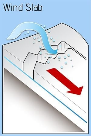
The storm snow from March 9-11 is now being transported by strong NE winds. Wind loads below high, leeward ridgelines are to be expected. These wind slabs may have high energy and are likely to to be triggered by human activity. Avoid them if possible. Also, watch for cross wind loaded gullies through the Thompson Pass corridor.
Likelihood:
- Almost Certain
- Very Likely
- Likely
- Possible
- Unlikely
Size:
- Historic
- Very Large
- Large
- Small
Trend
- Increasing
- Steady
- Decreasing
Problem 2
Februarys’ cold and dry weather caused faceting to occur in our snowpack. There is a lot of variability in our forecast area, but generally as you move north, poorer structure exists. 1-2 mm near surface facets exist underneath the 2/1 windboard. This layer of windboard varies in depth, thickness and hardness through the range, but in many areas is 2 feet down, up to a foot thick and pencil hard. Faceted snow beneath this wind affected snow is very difficult to affect due to its thickness and density, but could be triggered from thin areas of the slab, with large loads or changing weather. At this point triggering an avalanche at this layer is unlikely, but may reactivate as the season moves on and the windboard breaks down allowing a persons weight to penetrate the layer or as heat pushes deeper into the snowpack.
It will be important to keep an eye on these layers once precipitation returns to our area. The most likely areas to affect deeper persistent slab avalanches will be in the Continental zone, in rocky terrain where a thinner/more faceted snowpack exists. Careful snowpack assessment is necessary while traveling in the Continental zone.
Likelihood:
- Almost Certain
- Very Likely
- Likely
- Possible
- Unlikely
Size:
- Historic
- Very Large
- Large
- Small
Trend
- Increasing
- Steady
- Decreasing
Weather
THE THOMPSON PASS MOUNTAIN FORECAST COVERS THE MOUNTAINS (ABOVE
1000 FT) SURROUNDING KEYSTONE CANYON THROUGH THOMPSON PASS TO
WORTHINGTON GLACIER.
THIS FORECAST IS FOR USE IN SNOW SAFETY ACTIVITIES AND EMERGENCY
MANAGEMENT.
TONIGHT FRI
TEMP AT 1000′ 2- 8 F 11 F
TEMP AT 3000′ 12-19 F 11-18 F
CHANCE OF PRECIP 0% 0%
PRECIP AMOUNT
(ABOVE 1000 FT) 0.00 IN 0.00 IN
SNOW AMOUNT
(ABOVE 1000 FT) 0 IN 0 IN
SNOW LEVEL SEA LEVEL SEA LEVEL
WIND 3000′ RIDGES NE 9-37 MPH NE 8-43 MPH

