Valdez
Above 4,000ftModerate
2,000 to 4,000ftModerate
Below 2,000ftModerate
Degrees of Avalanche Danger
Avalanche Problems
Problem 1
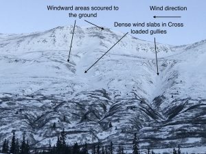
The latest wind storm that began on new years day has redistributed any soft snow that existed. Dense wind slabs 1-2 feet deep have formed on the lee side of terrain features such as top loaded slopes and cross loaded gullies. Windward slopes have been scoured down to old wind affected layers or the ground. Triggering one of these wind slabs in specific locations remains a possibility. Signs of instability such as large collapses have been noted on Thompson Pass as recently as 1/6 near the edges of dense wind slabs. Triggering a wind slab avalanche will remain possible longer than what is typical since they have been deposited on faceted snow in some locations.
The most likely place to trigger an avalanche will be near the edge of a slab where it is thinnest or on convex rollovers. The hazard for this avalanche problem will be slowly decreasing as wind slabs gain strength and bond to the underlying snow. Strong winds are forecasted to continue over the next 48 hours in wind channeled terrain. In most areas there is no more loose snow available for transport, which will limit the winds ability to build deeper slabs.

Likelihood:
- Almost Certain
- Very Likely
- Likely
- Possible
- Unlikely
Size:
- Historic
- Very Large
- Large
- Small
Trend
- Increasing
- Steady
- Decreasing
Problem 2
The majority of our avalanche concerns revolve around weak faceted snow created in November. In many places these facets have been capped by varying depths of hard wind slabs. This layering has made these facets more difficult to affect due to bridging, and signs of instability have decreased as well. Even though persistent slabs have become more stubborn to triggers a weak snowpack is still in place. Triggering one of these avalanches is unlikely but would carry high consequences if initiated.
The only effective practices for mitigating a persistent slab avalanche problem is conservative terrain choices and the use of safe protocols. Safe protocols include only exposing one person to an avalanche prone slope on the way up or down, having an escape route should a slope fail and maintaining good communication within your group.
The most likely places to trigger a persistent slab avalanche will be in thin rocky areas or anywhere the snowpack is thinner and the weak layer is closer to the surface. Other areas include places that have not been affected by recent wind events, and locations north of Thompson pass where colder temperatures has created an even weaker snowpack.
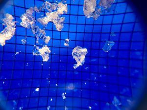
Photo of developed facets found on Catchers Mitt on 1/6, 2mm grid. The depth of these facets varies greatly depending upon wind redistribution. These were found just below the surface in a wind scoured area. On lee sides of terrain features facets may be found beneath 2-3+ feet of knife hard wind slabs.

Likelihood:
- Almost Certain
- Very Likely
- Likely
- Possible
- Unlikely
Size:
- Historic
- Very Large
- Large
- Small
Trend
- Increasing
- Steady
- Decreasing
Avalanche Activity
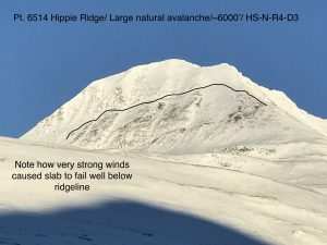
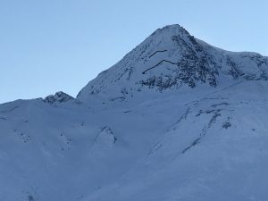
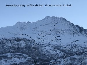
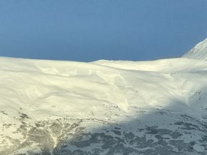
1/1-1/4- The new years day wind event created an avalanche cycle that was difficult to document due to crowns being rapidly reloaded by 80 mph winds. Below are photos of a couple very large slides that were still visible in the Hippie ridge area. Naturals were also noted on Three Pigs, 40.5 Mile, Crudbusters, Python Buttress.
12/29- Multiple natural wet loose D1-D2’s were observed in the Port of Valdez with no step downs noted.
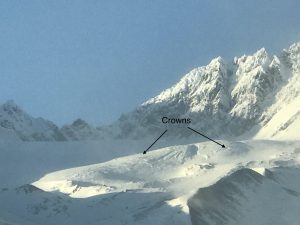
12/23- Berlin Wall north face ~5000′ HS-N-R3-D2-O. It is possible this occurred on 12/21, although it was not observed until 12/24.
12/21- Numerous natural avalanches observed all along the north side of Thompson Pass, as a result of strong NE wind event along with a couple inches of new snow and rising temperatures. Observed naturals on all aspects except windward slopes with crowns originating from 1000 feet to 5500 feet in elevation. Most of these were hard slab avalanches. Crown depths were difficult to discern due to reloading, although some crowns looked to be up to 2 meters in depth.
12/19- D 2.5 natural avalanches were observed on the north facing buttress west of Gully 1 and Schoolbus.
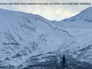
12/14- Several natural avalanches were observed although poor visibility prevented a full view of the action. The most notable natural was observed in Nicks Happy Valley on a NW aspect ~4000′. Crown depth was not visible. Debris ran down the valley and piled up at the typical snowmachine pickup.
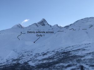
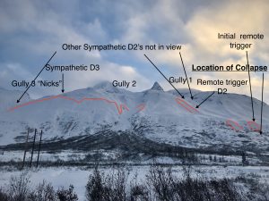
12/8- Large remote trigger/ sympathetic avalanche event occurred 12/8 with avalanches extending from Gully 1 to Nicks. Avalanches were soft slabs that ranged in size from D1-D3. Over 10 separate avalanches were counted with crown depths averaging 2-3′. One avalanche had a crown length of half a mile while another was triggered over a mile away from the point of collapse. See observation section for full report and more photos.
12/7- Only a few natural avalanches were noted during the last storm. It is likely there were more during the storm, but crowns may have been filled in by subsequent wind and snow.
D2’s on Town mountain was observed ~3000′
A couple of D2’s were noted in N. Oddessey gully and Big Oddessey.
D2 on 40.5 mile peak ~5500′.
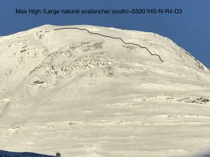
12/2-12/3- Several natural D2 avalanches were noted on south aspects of Three pigs, Hippie Ridge and Averys. These windslab avalanches originated between 4000-5500 feet elevation.
Weather
NWS Watches and Warnings
Northeast Prince William Sound-
Including the cities of Valdez and Thompson Pass
412 AM AKST Fri Jan 7 2022

...WIND CHILL ADVISORY REMAINS IN EFFECT UNTIL 1 PM AKST SATURDAY
THROUGH THOMPSON PASS...

* WHAT...Very cold wind chills occurring. Wind chills 45 below
  to 55 below zero.

* WHERE...Thompson Pass.

* WHEN...Until 1 PM AKST Saturday.

* IMPACTS...The dangerously cold wind chills could cause
  frostbite on exposed skin in as little as 5 minutes.
Point forecast for Thompson Pass
Detailed forecast for Thompson Pass (mid elevation 2000-4000′)
DATE             FRIDAY 01/07            SATURDAY 01/08
TIME (LT)        06    12    18    00    06    12    18    00    06
CLOUD COVER      FW    FW    SC    BK    BK    SC    SC    BK    OV
CLOUD COVER (%)   5     5    30    60    50    40    45    55    85
TEMPERATURE      -5    -5    -8    -8    -7    -5    -7    -7    -3
MAX/MIN TEMP                  1          -9          -3          -8
WIND DIR         NE    NE    NE    NE    NE    NE    NE    NE    NE
WIND (MPH)       32    29    23    19    18    17    19    20    21
WIND GUST (MPH)  62    62    56    48    43    42    42    48    57
PRECIP PROB (%)   0     0     5     0     5     0     0    10    70
PRECIP TYPE                                                       S
12 HOUR QPF                0.00        0.00        0.00        0.00
12 HOUR SNOW                0.0         0.0         0.0         0.0
SNOW LEVEL (KFT)0.0   0.0   0.0   0.0   0.0   0.0   0.0   0.0   0.0
Snow and Temperature Measurements
| Date: 01/07 | 24 hr snow | HN24W* | High Temp | Low Temp | Weekly SWE (Monday- Sunday) | January Snowfall | Season Snowfall | HS (Snowpack depth) |
| Valdez | 0 | 0 | 29 | 2 | 0 | 0 | 83 | 20 |
| Thompson Pass | 0 | 0 | 0 | -24 | 0 | 0 | 165 | 24 |
| 46 Mile | 0 | 0 | -15 | -23 | 0 | 1 | 31** | 19
|
All snowfall measurements are expressed in inches and temperature in Fahrenheit. 24 hour sample period is from 6am-6am.
* 24 hour snow water equivalent/ SWE.
** Season total snowfall measurements for 46 mile began December 1st.
Season history graphs for Thompson Pass
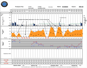
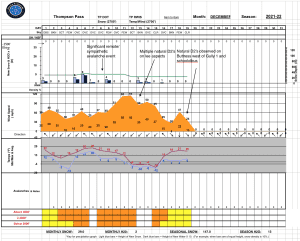
Click on links below to see a clear and expanded view of above Season history graphs
Additional Information
Winter weather began early this season, with valley locations receiving their first snowfall on the last day of Summer (September 21st). Following this storm, above average temperatures and wet weather occurred from late September through early November. During this time period Thompson Pass received 96 inches of snowfall by November 7th and Valdez recorded 7.73″ of rain.
After the 7th of November our region experienced a sharp weather pattern change. Temperatures dropped below seasonal norms and snowfall became infrequent. Between the time frame of November 7th- November 28th Thompson Pass only reported 19″ of snow with 1.1″ of Snow water equivalent (SWE). Temperatures remained below 0° F for most of the period. This cold/dry weather caused significant faceting of the snowpack, with poor structure the result.
Moderate snowfall returned to our area the last day of November and deposited 6-12 inches of new snow. The amount varied depending upon the locations’ proximity to the coast. As the storm exited on the 2nd of December it was quickly replaced by moderate to strong northeast winds.
On 12/5-12/6 Valdez received 2 feet of new snow with Thompson Pass reporting 16″. Blaring red flags like collapsing, shooting cracks and propagation in stability tests were immediately present. On 12/8 a significant remote/ sympathetic avalanche event occurred from Gully 1 through Nick’s Happy Valley.
Strong outflow winds began on 12/11 with periods of light snowfall. This has caused slab thicknesses to become variable in areas exposed to NE winds.
A fair amount of natural avalanche activity occurred during the 12/11 wind event mostly on southerly aspects. The week following this wind event fairly benign weather occurred which allowed the snowpack to adjust and for stability to improve although snowpack structure has remained poor.
On 12/21 our area received a couple inches of snow along with temperatures rising and strong outflow winds. This combination of weather kicked off a fairly significant natural avalanche cycle. Many of the slabs appeared to be deeper wind slabs that were created from the 12/11 wind event. These failed on faceted snow created in November. The event is yet another indicator of our poor snowpack structure and its inability to receive any major change in weather without the avalanche hazard rising in conjunction.
On 12/26-28 warm air moved in at elevation and caused light rain to fall up to ~4000′. A very thin rain crust was formed in many locations that was unable to support a persons weight.
A prolonged period of strong north winds began on new years day with wind speeds reaching 80 mph. As winds tapered to 30-40 mph on the 5th temperatures plummeted with lows exceeding -30 F in the Tsaina valley.
Announcements
The avalanche hazard is Moderate at all elevations. Human triggered wind slab avalanches remain possible 1-2 feet deep. Although unlikely, there remains a small chance that shallow wind slabs could step down to deeper layers in the snowpack and create large hard slab avalanches 2-3+ feet in depth.
Click the + Full Forecast button below for a list of current avalanche problems, travel advice, weather resources and more.
Help to improve your local avalanche center and contribute an observation to the website. You can also contact me directly at [email protected] (907)255-7690.