Hatcher Pass
Above 3,500ft Moderate
2,500 to 3,500ft Considerable
Below 2,500ftConsiderable
Degrees of Avalanche Danger
Avalanche Activity
Natural and human triggered wet-loose and natural wet-slabs were observed most of the week. Most wet-loose were small in size, in terrain 40° and steeper, and on ALL aspects, and all elevations. The largest avalanches were up to D2 in size, at all elevations, on SE to S aspects.
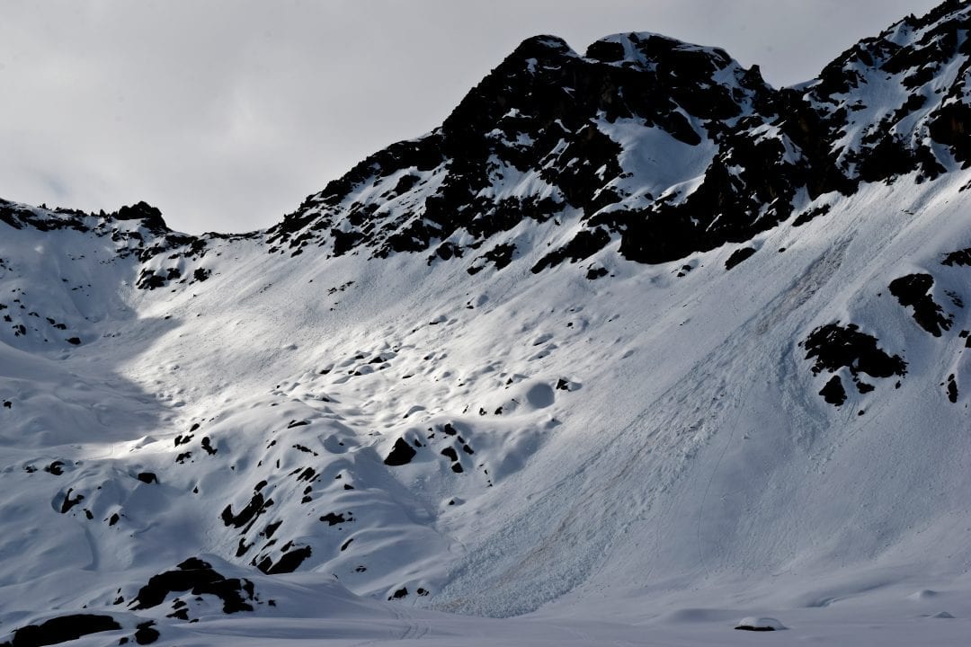
Many large cornices have failed naturally, triggering persistent slab avalanches. Large to extra large cornice chunks have fallen naturally too.
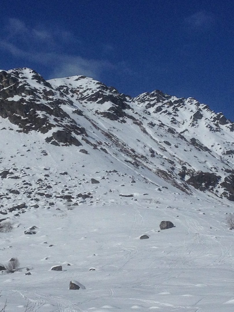
Above: 3/29 Large wet-loose archangel valley, SE aspect, 3700′.

Above: 3/29 Natural wet loose to the ground near Presidents of Marmot, SE aspect 3400′
Above: 3/29 Wet loose and wet-slab. 4500′ SE Birthday / High Grade Pass.

Above: 3/29 Large cornices exist on many upper elevation leeward aspects and have been breaking naturally this week. Friendship Pass.
For more info and pictures on the Natural and Human triggered avalanches this week , check out the mid week summary, HERE or weekly OBSERVATIONS HERE.
Weather
This week’s weather at Independence Mine 3550′:
Temps averaged 33ºF, with a low of 25ºF and a high of 43ºF.
IM recorded 4” of new snow and .3″ water (SWE) since 3/23.
Overnight at 3550′:
Temps averaged 28°F.
No new snow.
This week’s weather at Marmot Weather Station 4500′:
Temps averaged 28ºF, with a low of 22ºF and a high of 40ºF.
Winds averaged SSE 5 mph, max 17 mph . Gusts averaged SSE 9 mph, max gust SSE 27 mph.
Overnight at 4500′:
Temps averaged 24ºF overnight.
Winds averaged E 3 mph overnight. Max gust E 9 mph.
NWS Rec Forecast HERE
NWS point forecast HERE
State Parks Snow Report and Motorized Access information HERE
Additional Information
TREND
Avalanche danger will remain the same until we see a continued lack of freezing at night. Sunny skies, warm days, and freezing temps at upper elevation should persist through the weekend.
Alerts
Read entire HPAC advisory HERE.
Announcements
UPDATE: Saturday 3/30 at 5pm, expires in 24 hours
 Low danger in the morning will rise to CONSIDERABLE by mid day for WET loose and WET slab avalanches, up to D2, on SE to SW aspects, on slopes above 30º, at all elevations. Natural avalanches are possible and human triggered are likely. Large avalanches in specific areas will be possible. A large human triggered wet slab occured today at 11:45am on the SE aspect of Skyscraper, large enough to bury, injure, or kill. Wet slabs are hard to predict and can be remotely triggered. Despite overnight freezing, daytime temps are RISING RAPIDLY and may catch you off-guard.
BOTTOM LINE for March 30 at 7am, expires in 24 hours.
The avalanche danger today is LOW in the morning, rising to CONSIDERABLE in the afternoon for Wet Avalanches at low and mid elevations, most likely in the afternoon and evening on steep SE to SW aspects. Most avalanches will be small in size although large avalanches up to D2 will be possible on S aspects at low and mid elevation in the pm. A MODERATE danger exists at upper elevation for wet avalanches in the afternoon on SE to SW steep slopes.
Cornices are huge and will be possible for a human or dog to trigger today. Cornices will have the potential to trigger larger sluffs or slab avalanches that may fail to the ground. Large cornice chunks have been observed below many leeward slopes.
A slightly cooler trend this week with overnight freezing temperatures at upper elevation has significantly improved conditions. Time of day and aspect choice will be key for pure enjoyment, staying safe, and avoiding avalanches.
Announcements:
Heading to Turnagain? Be sure to check the CNFAIC Forecast HERE.