Valdez
Above 4,000ftModerate
2,000 to 4,000ftModerate
Below 2,000ftModerate
Degrees of Avalanche Danger
Avalanche Problems
Problem 1
The effect of the Spring sun is in full affect and with it comes a variety of hazards. Wet loose avalanches are the most common hazard to encounter. This occurs when the sun heats up the snow surface enough to become wet and lose strength. This process creates point release slides that entrain more snow as they move down hill. These can be small-very large depending upon the steepness and relief of the slope they occur on. These go through a daily cycle with east aspects being the first to be affected then moving to south and finally west. Steep rocky terrain is the most easily affected due to rocks soaking up the suns energy and transferring it to the surrounding snow.
Wet loose avalanches have the potential to step down to deeper layers in the snowpack triggering much more destructive slab avalanches. Other hazards of the spring include cornice fall. Cornices are losing strength each day as they are baking in the sun. Avoiding exposure to cornices is highly recommended. Two cornice fall events in the last 4 days have resulted in very large natural avalanches, with multiple step downs occurring resulting in failure at the ground (see avalanche activity section).
Avoid traveling on or below steep solar aspects during the heat of the day and traveling on or exposing yourself to cornices.

Likelihood:
- Almost Certain
- Very Likely
- Likely
- Possible
- Unlikely
Size:
- Historic
- Very Large
- Large
- Small
Trend
- Increasing
- Steady
- Decreasing
Problem 2
Settled storm snow depths since 4/5 vary significantly across our forecast zone, with some areas only having a few inches and others having as much as 2 feet. Settled storm snow rests on a variety of surfaces that will affect the likelihood of human triggered avalanches that may occur 1-2 feet in depth. Bed surfaces range from hard wind board, melt freeze crusts, near surface facets and buried surface hoar. In areas where deeper storm totals overlie near surface facets or buried surface hoar, human triggered avalanches are possible. The sensitivity of these slabs will increase during specific times of the day when the sun is perpendicular to a slope. Assess the interface between the settled powder at the surface and hard older layers beneath on a slope by slope basis.
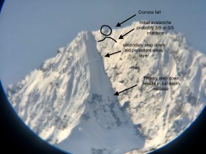
Deeper in the snowpack faceted snow exists in most location at and below the 3/17 interface. A very large natural avalanche occurred on Meteorite on 4/15. This avalanche was triggered by cornice fall that created a series of step-down avalanches. This a clear indicator that large triggers can tip the scales on weak layers in the mid and lower snowpack (see problem 4). The changing of seasons bringing warming temps increases the likelihood for more events similar to Meteorite to occur in the coming weeks.

Likelihood:
- Almost Certain
- Very Likely
- Likely
- Possible
- Unlikely
Size:
- Historic
- Very Large
- Large
- Small
Trend
- Increasing
- Steady
- Decreasing
Problem 3
Moderate north winds on 4/17-18 have kicked up through Thompson Pass, high elevation ridge lines and other wind exposed terrain. Shallow wind slabs may have formed in specific areas that may be reactive to human triggers less than 1 foot in depth. Pay attention to wind affect at the surface and the sensitivity of the surface snow where you choose to travel. Wind slabs may have been deposited on near surface facets that have been forming at the surface during the last couple days of clear weather. This would make the sensitivity of wind deposits higher in those locations.
Winds are forecasted to have decreased in strength overnight and are forecasted to be light over the next few days. This will lower the likelihood of this avalanche problem as time goes on.

Likelihood:
- Almost Certain
- Very Likely
- Likely
- Possible
- Unlikely
Size:
- Historic
- Very Large
- Large
- Small
Trend
- Increasing
- Steady
- Decreasing
Problem 4
This may be the last problem on the list and least likely to encounter, but it is the most dangerous one. There have been 2 reports in the last 4 days of cornice fall causing very large persistent slabs to full depth avalanches (see avalanche activity section). Avoiding traveling on or exposing yourself to cornices is highly recommended.
Weak snow exists at the base of our snowpack. On 4/15 our area saw the first deep slab activity occur since late February. This occurred on Meteorite (see avalanche activity section) and was a cornice fall that triggered a series of step down avalanches that eventually stepped down to the ground. This is a clear indication that large triggers can have an affect on depth hoar. Increasing temperatures could produce more significant activity later in the season while our snowpack is undergoing a transition from a winter snowpack to a spring one.
This problem is very difficult to assess due its depth and the fact that signs of instability will likely not be present. You can stack the odds in your favor by avoiding steep terrain that is undergoing rapid changes such as strong solar and avoiding exposure to large triggers such as cornices.

Likelihood:
- Almost Certain
- Very Likely
- Likely
- Possible
- Unlikely
Size:
- Historic
- Very Large
- Large
- Small
Trend
- Increasing
- Steady
- Decreasing
Avalanche Activity
Below is a summary of observed Avalanche activity from the last 7 days. Avalanches that were noted earlier in the season can be viewed by clicking the link below.
If you trigger or observe an avalanche consider leaving a public observation.
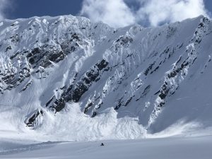
4/17- Large natural avalanche reported on the upper Tasnuna just east of “The Wall”. Cornice fall was likely the initial trigger with other sympathetic avalanches occurring as well as full depth step downs. SS-Nc-R2.5-D3
– Skier triggered avalanche reported in the Tasnuna valley “The Hammer” SS-ASu-D2-I down 40 cms on 4/7 buried surface hoar/ NE aspect ~5500′. 5th Skier on slope was caught and partially buried in a crevasse/ skier did not sustain any major injuries.
4/15- A cornice fall produced a series of step down avalanches on Meteorite which resulted in failure at the ground. This intiatied as a cornice fall at 6500′ that triggered an avalanche most likely at the 3/9 interface which then stepped down to a persistent slab around 6100′ NE and stepped down to the ground at 5600′ NE.
SS/HS-NC-D3-O/G 6200′ NE, step down to ground ~5600′ NE
4/9- Skier triggered D2 avalanche reported on a wind loaded NW aspect of Berlin Wall ~5400′. Skier was caught and carried, but not buried/ no injuries.
Small wind loaded pockets D1-1.5 were observed to be sensitive to human triggers in cross loaded terrain on Billy Mitchell.
4/7- Numerous D1-1.5 natural dry loose avalanches observed that occurred mid storm 4/5-6. No step downs observed.
Several small (D1) human triggered avalanches were observed along the road corridor where the new snow had been wind affected.
4/6- Skier triggered D1 reported in Gully 1 on a wind loaded convexity.
Weather
Check out our updated weather tab! A collection of local weather stations are available for viewing with graphs and tabular data included.
NWS Watches, warnings and advisories
NONE
NWS Point forecast for Thompson Pass
Date                     Wednesday 04/19/23      Thursday 04/20/23
Time (LT)          04    10    16    22    04    10    16    22    04
Cloud Cover        SC    SC    FW    SC    SC    FW    FW    SC    FW
Cloud Cover (%)    45    40    20    40    30    20    15    25    25
Temperature        21    27    37    28    22    29    38    29    24
Max/Min Temp                   37          22          38          24
Wind Dir           NE    NE    NE    NE    NE    NE    NE    NE     N
Wind (mph)         11    10     9    12    10    10     9    11    13
Wind Gust (mph)
Precip Prob (%)     0     0     5     0     0     0     0     0     0
Precip Type
12 Hour QPF                  0.00        0.00        0.00        0.00
12 Hour Snow                  0.0         0.0         0.0         0.0
Snow Level (kft)  0.3   0.6   1.6   1.0   0.8   0.9   2.2   1.6   1.6
Click on link below for Thompson Pass weather history graph:

| Date:
04/19 |
24 hr snow | HN24W* | High temp | Low temp | 72 hour SWE* | April snowfall | Seasonal snowfall | Snowpack Depth |
| Valdez | 0 | 0 | 46 | 29 | 0 | 11 | 248 | 41 |
| Thompson Pass | 0 | 0 | N/O | N/O | 0 | 12 | 438 | N/O |
| 46 mile | 0 | 0 | 44 | 20 | 0 | ~5 | ~116** | 45 |
*HN24W- 24 hour Snow water equivalent in inches
*SWE– Snow water equivalent
**46 mile seasonal snowfall total begins December 1st.
Additional Information
Click on the link below for a running summary of the seasons weather history.
Announcements
The avalanche hazard is moderate at all elevation. Human triggered avalanches are possible 1-2 feet in depth in isolated areas where 8-16 inches of settled storm snow sits on near surface facets or buried surface hoar. Human triggered wet loose avalanches are likely on steep solar aspects at low-mid elevations. Be aware that all of the spring time hazards are currently a concern. These include; wet loose activity that becomes more likely throughout the day, wet slab avalanches, cornice fall and snow bridges losing strength on glaciers. Avoid exposure to steep solar aspects during the heat of the day and assess the interface beneath the settled April storm snow, if traveling in steep and or consequential terrain.
Posted by Gareth Brown 04/19 8:00 am.
For a description of current avalanche problems, weather information, season history and more click the (+ full forecast) button. Avalanche forecasts will be issued Wednesday-Sunday through April 30th.
If you have pictures of recent natural or human triggered avalanches or notice signs of instability such as shooting cracks or collapsing, leave an observation to help improve forecast accuracy.