Valdez
Above 4,000ftModerate
2,000 to 4,000ftModerate
Below 2,000ftModerate
Degrees of Avalanche Danger
Avalanche Problems
Problem 1
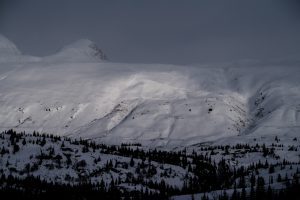
The strong inversion that took place over the last couple of days is breaking down, allowing for temperatures to drop below freezing at mid and upper elevations. This has allowed the snowpack to gain strength at the surface, decreasing the likelihood for human triggered avalanches today.
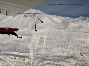
Numerous D1-D2 wet loose activity was observed and reported on SE-SW aspects on 3/8. Some of these wet loose slides were observed as stepping down and producing slab avalanches failing on a suspected persistent weak layer (see problem 2). Wet loose activity is expected to continue today during the heat of the day, although cloud cover is possible that would limit the suns affect. Pay attention to what the sun is doing to the surface snow where you choose to travel and avoid slopes steeper than 35° that are becoming moist-wet.

Likelihood:
- Almost Certain
- Very Likely
- Likely
- Possible
- Unlikely
Size:
- Historic
- Very Large
- Large
- Small
Trend
- Increasing
- Steady
- Decreasing
Problem 2
A drop in temperatures overnight to below freezing at mid and upper elevations will decrease the sensitivity of persistent weak layers near the surface. The 2/23 layer of buried surface hoar exists in isolated locations and is most likely to be encountered on south aspects at mid elevation. This has been shown by the recent natural avalanche activity that has been occurring on south aspects in the mid elevation band over the last week. This layer is not likely to exist in close proximity to Thompson Pass or other wind channeled terrain, as it was likely stripped away by outflow winds before it could be buried on 2/23.
Other persistent layers of concern exist in the mid snowpack but are unlikely to be affected by human or machine triggers due to their depth. Large triggers such as cornice and ice fall have been responsible for producing very large avalanches over the last two weeks. It is important to be aware that these weak layers exist and realize the most likely place to affect them will be in areas where the snowpack is thin and these layers are closer to the surface. The weak layers mentioned above include the 1/14 buried surface hoar which is likely the responsible failure plane of some very large recent avalanches triggered by cornice fall and has been observed at a depth of 70-150cms.
Another layer we are tracking in the mid snowpack is the 1/25 rain crust/ facet combo. This layer exists below 2500′. Collapsing in the Intermountain and Continental zone has been observed at low elevations failing at this layer. Natural and human triggered avalanches have not been reported at this layer and stability tests continue to show a lack of significant results and rough shears. Even though human triggered avalanches are unlikely at this layer, it is still worth investigating if choosing to travel in steep consequential terrain at low elevations.

Likelihood:
- Almost Certain
- Very Likely
- Likely
- Possible
- Unlikely
Size:
- Historic
- Very Large
- Large
- Small
Trend
- Increasing
- Steady
- Decreasing
Problem 3
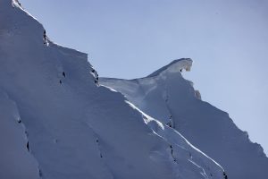
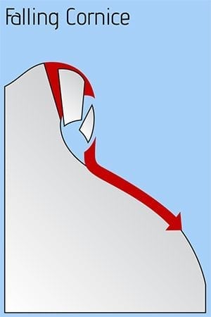
Several large avalanches resulting from cornice fall have been reported and observed over the last 2 weeks. Cornices have been observed and reported as being larger than normal and poorly attached. Cracks on ridge tops showing cornices separating from ridge lines have been observed and reported. Cornices have continued to grow in size with strong winds.
Cornices are an objective mountain hazard that should always be a concern. Although, recent activity strongly shows that we need to keep an extra cautious approach to avoiding overhead exposure to cornices. Avoid traveling below or on top of cornices. The avalanches that cornice fall has recently produced have been very large and likely unsurvivable.
Likelihood:
- Almost Certain
- Very Likely
- Likely
- Possible
- Unlikely
Size:
- Historic
- Very Large
- Large
- Small
Trend
- Increasing
- Steady
- Decreasing
Problem 4
Recent outflow winds have stripped many areas with has led to an overall decrease in the mass of our snowpack. Some areas did see depositions add to the depth of the pack, but the strength of winds we received has done more scouring, stripping and sublimating than redistributing and depositing. One effect of this, other than damaging riding conditions is that depth hoar is now closer to the surface. Depth hoar has been dormant nearly the entire season and has not been a major concern except during major loading events. The most likely place to affect this deep layer are in areas where the snowpack is thin and a person or machines weight can directly effect this weak snow. The overall snowpack has become thinner over the last week in most locations. This has in turn created a net increase in probability of affecting this weak snow, especially as wind slabs at the surface loose strength due to diurnal faceting. Another affect of depth hoar being closer to the surface is that these grains that are currently rounded may be moving toward faceting as temperature gradients increase. Currently affecting this layer remain unlikely. Although, may become an issue later in the season especially if our snowpack continues to be eroded by strong wind events, and an extended period of clear and cold.
This weak snow mentioned above was created by early season cold temps, dry conditions and strong north winds. Poor structure near the base of the snowpack has been observed since late November. Mild temperatures and consistent snowfall during mid winter allowed this weak snow to slowly round and gain strength. This weak snow has been dormant through the majority of the season with human triggered avalanches being unlikely at this layer. As the sun has come out on 2/20 for the first time in weeks several very large natural avalanches occurred with cornice and ice falls being the triggers. Human triggers remain unlikely at this layer, although these events show that large triggers can affect this weak snow. Cornice fall will be the most likely trigger to affect this weak snow, although it is possible that a large group could have the same affect. Avoid overhead exposure to cornices.
In most location facets near the ground have been found to be rounding and unreactive in stability tests. In thin areas of the snowpack basal facets have been found to be more developed. If you find it is possible to push a ski pole to the ground in areas you travel, assume that a weak faceted snowpack exists in that location. These areas could act as a trigger point.

Likelihood:
- Almost Certain
- Very Likely
- Likely
- Possible
- Unlikely
Size:
- Historic
- Very Large
- Large
- Small
Trend
- Increasing
- Steady
- Decreasing
Avalanche Activity
Below is a summary of observed Avalanche activity from the last 7 days. Avalanches that were noted earlier in the season can be viewed by clicking the link below.
If you trigger or observe an avalanche consider leaving a public observation.
3/4- Lower Girls- SSE ~ 4200′ HS-N-D2
3/3-Natural D2 wind slab avalanche that likely failed on persistent weak layer judging by the length of propagation. 2/23 BSH is the suspected weak layer. Hippy Ridge/ South/ ~3800′
Weather
Check out our updated weather tab! A collection of local weather stations are available for viewing with graphs and tabular data included.
NWS Watches and warnings
...HIGH WIND WARNING REMAINS IN EFFECT UNTIL NOON AKST TODAY...

* WHAT...Northeast winds 30 to 50 mph with gusts up to 75 mph
  expected.

* WHERE...Valdez through Thompson Pass.

* WHEN...Until noon AKST today.

* IMPACTS...High winds may move loose debris, damage property,
  and cause power outages. Travel will be difficult, especially
  for high profile vehicles.

* ADDITIONAL DETAILS...Winds will strengthen tonight and peak
  late tonight through Saturday morning. Gusty conditions are
  expected to diminish slowly throughout the day Saturday,
  becoming significantly less intense by Saturday evening.
  Isolated areas of blowing and drifting snow could briefly
  reduce visibilities to one quarter mile. Wind chills to 35 -
  degrees Fahrenheit overnight tonight through Thompson Pass.
NWS Point forecast for Thompson Pass
Date               Saturday 03/04/23       Sunday 03/05/23
Time (LT)          06    12    18    00    06    12    18    00    06
Cloud Cover        CL    FW    FW    FW    FW    CL    FW    FW    FW
Cloud Cover (%)     0     5    15    20    10     5     5    10    15
Temperature         5     8     6     5     8    18    18    13    14
Max/Min Temp                    9           4          24          13
Wind Dir           NE    NE    NE    NE    NE    NE    NE    NE     N
Wind (mph)         33    31    27    23    20    16    16    13    13
Wind Gust (mph)    73    70    41    36    32                      27
Precip Prob (%)     0     0     0     0     0     0     0     0     0
Precip Type
12 Hour QPF                  0.00        0.00        0.00        0.00
12 Hour Snow                  0.0         0.0         0.0         0.0
Snow Level (kft)  0.0   0.0   0.0   0.0   0.0   0.0   0.1   0.1   0.4
Click on link below for Thompson Pass weather history graph:

| Date:
03/08 |
24 hr snow | HN24W* | High temp | Low temp | 72 hour SWE* | March snowfall | Seasonal snowfall | Snowpack Depth |
| Valdez | 0 | 0 | 46 | 24 | 0 | 2 | 218 | 62 |
| Thompson pass | 0 | 0 | 39 | 32 | 0 | 5 | 373 | N/O |
| 46 mile | 0 | 0 | 38 | 14 | 0 | 0 | ~85** | 42 |
*HN24W- 24 hour Snow water equivalent in inches
*SWE– Snow water equivalent
**46 mile seasonal snowfall total begins December 1st.
Additional Information
Click on the link below for a running summary of the seasons weather history.
Announcements
The avalanche hazard is Considerable at all elevations. Above freezing temperatures overnight at mid and upper elevations will be putting stress on the snowpack. Human triggered avalanches will be likely on aspects being affected by the sun. Natural avalanches will be possible.
Posted by Gareth Brown 03/08 8:00 am.
For a description of current avalanche problems, weather information, season history and more click the (+ full forecast) button. Avalanche forecasts will be issued Wednesday-Sunday.
If you have pictures of recent natural or human triggered avalanches or notice signs of instability such as shooting cracks or collapsing, leave an observation to help improve forecast accuracy.