Valdez
Above 4,000ftConsiderable
2,000 to 4,000ftModerate
Below 2,000ftModerate
Degrees of Avalanche Danger
Avalanche Problems
Problem 1
Another outflow wind event is taking shape that will likely last through mid day Monday. Snow available for transport amounts vary fairly significantly across the forecast area, this will affect the depth of new wind slab formation. Most areas have sufficient loose snow at the surface to form wind slabs on SE-NW aspects in areas being affected by the wind. Expect to find fresh wind slabs that are 6-18 inches in depth that will be reactive to human triggers.
Another variable factor will be the surface that wind slabs are being deposited on. These will range from old wind slabs, new snow from 2/23 and a layer of buried surface hoar that exists directly under the 2/23 new snow. Areas where wind slabs overlies the 2/23 buried surface hoar will be the most sensitive. Shallow hand pits can help to determine what wind slabs are being deposited on. Watch for red flags such as shooting cracks, collapsing and recent avalanche activity that would indicate unstable snow at the surface.

Likelihood:
- Almost Certain
- Very Likely
- Likely
- Possible
- Unlikely
Size:
- Historic
- Very Large
- Large
- Small
Trend
- Increasing
- Steady
- Decreasing
Problem 2
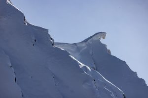
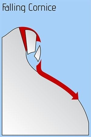
Falling cornices have been reported in multiple locations over the last week. These have produced D3 (very large) avalanches at high elevations of The Books , PK 7601 (Tsaina/ Tonsina Pass) and Woodworth area. Cornices have been observed and reported as being larger than normal and poorly attached. Cracks on ridge tops showing cornices separating from ridge lines have been observed and reported. Cornices will be growing in size today as a outflow (north) wind event develops.
Cornices are an objective mountain hazard that should always be a concern. Although, recent activity strongly shows that we need to keep an extra cautious approach to avoiding overhead exposure to cornices. Avoid traveling below or on top of cornices. The avalanches that cornice fall has recently produced are unsurvivable events.
Likelihood:
- Almost Certain
- Very Likely
- Likely
- Possible
- Unlikely
Size:
- Historic
- Very Large
- Large
- Small
Trend
- Increasing
- Steady
- Decreasing
Problem 3
Natural avalanche activity caused by cornice fall reported on 2/22 indicates that a persistent weak layer in the mid snowpack exists at upper elevations. The 1/14 buried surface hoar layer is likely the weak layer involved, although this has not been confirmed. This layer has been quiet for over three weeks, but recent activity shows that large triggers can still produce avalanches. Human triggered avalanches remain unlikely at this layer although large groups, cornice/ice fall may be able to still produce avalanches at this layer. The most likely places to encounter this interface to be sensitive will be in thinner snowpacks like what may be found in the Continental zone.
Rain crusts that formed in late January have promoted faceting in the mid snowpack at low elevations (below 2500′). No natural or human triggered avalanches have been reported or observed that failed at this layer, although poor structure exists and stability tests have produced propagation at this interface in isolated locations.
As time goes on and this layer becomes deeper in the snowpack with additional snowfall, the likelihood of human triggers will be decreasing. It is still worth investigating this layer if traveling in steep/ consequential terrain at low elevations. Areas where the snowpack is thin will be the most susceptible to failures at this plane.

Likelihood:
- Almost Certain
- Very Likely
- Likely
- Possible
- Unlikely
Size:
- Historic
- Very Large
- Large
- Small
Trend
- Increasing
- Steady
- Decreasing
Problem 4
Weak snow created by early season cold temps, dry conditions and strong north winds have showed poor structure near the base of the snowpack. This weak snow has been dormant through the majority of the season with human triggered avalanches being unlikely at this layer. As the sun has come out last week several very large natural avalanches have occurred with cornice and ice falls being the triggers. Human triggers remain unlikely at this layer, although these events show that large triggers can affect this weak snow. Cornice fall will be the most likely trigger to affect this weak snow, although it is possible that a large group could have the same affect. Avoid overhead exposure to cornices.
In most location facets near the ground have been found to be rounding and unreactive in stability tests. In thin areas of the snowpack basal facets have been found to be more developed. If you find it is possible to push a ski pole to the ground in areas you travel, assume that a weak faceted snowpack exists in that location. These areas could act as a trigger point.

Likelihood:
- Almost Certain
- Very Likely
- Likely
- Possible
- Unlikely
Size:
- Historic
- Very Large
- Large
- Small
Trend
- Increasing
- Steady
- Decreasing
Avalanche Activity
Below is a summary of observed Avalanche activity from the last 7 days. Avalanches that were noted earlier in the season can be viewed by clicking the link below.
If you trigger or observe an avalanche consider leaving a public observation.
2/22- Natural D 2.5 cornice fall avalanche was reported on a NW aspect/ ~6000 in the books. 
2/20- Numerous D1-D2 natural and human triggered avalanches were observed and reported up to 1 foot in depth on a variety of aspects. These occurred in areas where fresh wind slabs were present.
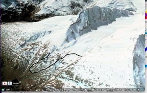
– D3 natural avalanche observed on Snoopys (Port of Valdez). NW aspect/ ~5000’/ ran ~3500 vertical feet with a track length of approximately 1 mile mapped on Google Earth. This was a hard slab avalanche the failed at weak layer in the mid snowpack. HS-N-R4 D3. No other avalanches of this size have been observed or reported in our forecast area.
Weather
Check out our updated weather tab! A collection of local weather stations are available for viewing with graphs and tabular data included.
NWS Watches and warnings
NONE
NWS Point forecast for Thompson Pass
Date               Saturday 02/25/23       Sunday 02/26/23
Time (LT)          06    12    18    00    06    12    18    00    06
Cloud Cover        SC    SC    SC    SC    FW    FW    CL    FW    FW
Cloud Cover (%)    45    35    25    25    15     5     5    10    10
Temperature         7    14    12     7     5     6     3    -1    -4
Max/Min Temp                   16           5           7          -4
Wind Dir           NE    NE     N    NE    NE     N     N    NE    NE
Wind (mph)         21    19    20    20    23    25    26    23    23
Wind Gust (mph)    40    50    46    40    40    46    51    48    43
Precip Prob (%)     0     0     0     0     0     0     0     0     0
Precip Type
12 Hour QPF                  0.00        0.00        0.00        0.00
12 Hour Snow                  0.0         0.0         0.0         0.0
Snow Level (kft)  0.0   0.0   0.0   0.0   0.0   0.0   0.0   0.0   0.0
Click on link below for Thompson Pass weather history graph:

| Date:
02/25 |
24 hr snow | HN24W* | High temp | Low temp | 72 hour SWE* | February snowfall | Seasonal snowfall | Snowpack Depth |
| Valdez | 0 | 0 | 34 | 11 | .3 | 72 | 218 | 62 |
| Thompson pass | N/O | N/O | N/O | N/O | N/O | 69 | 356 | 67 |
| 46 mile | 0 | 0 | 32 | 12 | 0 | ~16 | ~85** | 42 |
*HN24W- 24 hour Snow water equivalent in inches
*SWE– Snow water equivalent
**46 mile seasonal snowfall total begins December 1st.
Additional Information
Click on the link below for a running summary of the seasons weather history.
Announcements
The avalanche hazard is Considerable above 4000′ and Moderate below. Human triggered avalanches are likely up to 1 foot in depth, natural avalanches are possible. A north wind event is forecasted to build today which may produce gusts up to 50 mph along high elevation ridge lines and in wind channeled terrain. New snow that fell 2/23 will be redistributed by moderate to strong north winds and will form wind slabs that are expected to be sensitive to human triggers. In addition, avoid traveling on or below cornices. These have failed in multiple locations over the last week and produced very large avalanches. Cornices are expected to grow in size as north winds redistribute snow along ridges.
Posted by Gareth Brown 02/25 8:00 am.
For a description of current avalanche problems, weather information, season history and more click the (+ full forecast) button. Avalanche forecasts will be issued Wednesday-Sunday.
If you have pictures of recent natural or human triggered avalanches or notice signs of instability such as shooting cracks or collapsing, leave an observation to help improve forecast accuracy.