Valdez
Above 4,000ftConsiderable
2,000 to 4,000ftConsiderable
Below 2,000ftModerate
Degrees of Avalanche Danger
Avalanche Problems
Problem 1
North winds are forecasted to slowly ramp up during the day 2/19 and peak the evening of 2/20. During this time fresh wind slabs will be forming that will be reactive to human or machine triggers. These will be shallow initially (less than 1 foot), but will increase in depth (1-3 feet) as the wind event develops and gains strength. Wind slabs can be identified by areas where the snow is stiffer at the surface than underlying snow. Visual indicators include textured snow surfaces, pillowed snow and freshly formed cornices on terrain features. Shooting cracks, collapsing and natural avalanche activity are all indicators that unstable snow exists that is capable of producing avalanches. Avoid slopes steeper than 30° that have been recently loaded, or are being actively loaded by wind.
There is currently a lot of dry snow available for transport. This will allow slabs to quickly form and are expected to be initially sensitive. Better stability and riding conditions can be found by seeking out areas that are sheltered from the wind.

Likelihood:
- Almost Certain
- Very Likely
- Likely
- Possible
- Unlikely
Size:
- Historic
- Very Large
- Large
- Small
Trend
- Increasing
- Steady
- Decreasing
Problem 2
As the sun comes out today expect for the likelihood of wet loose point release avalanches to become likely on solar aspects. There is a lot of dry snow at the surface down to sea level. Steep south aspects near the coast will be the first to be affected. The size of these point releases will directly correlate with the size of the slope where they occur. Avoid steep south facing terrain at low elevations that is being warmed by the sun.
At higher elevations dry loose point release avalanches will be occurring as well, especially on solar aspects. If attempting to travel in steep terrain today pay attention to the entire piece of terrain. Are there cornices, is there steep solar aspects connected? Natural sluffs were observed on 2/18 in steep north facing terrain. Expect this activity to increase today as the sun comes out.

Likelihood:
- Almost Certain
- Very Likely
- Likely
- Possible
- Unlikely
Size:
- Historic
- Very Large
- Large
- Small
Trend
- Increasing
- Steady
- Decreasing
Problem 3
Human triggered avalanches are possible up to 3 feet in depth below 2500′ in the Maritime climate zone. A rain crust created on 1/25 has formed a potentially dangerous persistent weak layer in the Maritime zone at low elevations, this includes Keystone Canyon. This layer has been identified on Thompson Pass and north although, has been found to be much less of a concern in those areas. The possibility of human triggered avalanches can’t be ruled out in steep and/or unsupported terrain north of Thompson Pass at low elevations.
On 2/16 this rain crust was found to have signs of instability at 1800′ just east of Benzene Alley (Port of Valdez). These include one very large collapse and propagation present in both ECT‘s and PST‘s repeated multiple times 3 feet down (see observation page). The depth of this layer will make it difficult to trigger in most locations, but the consequences would be high due to the depth of the slab. This weak layer was previously found to be faceting creating an area of poor structure, although only recently has propagation popped up in stability tests. This may indicate that the amount of snow we have received near the coast may be pushing this weak layer towards the tipping point. Careful assesment of this layer is advised especially if traveling in steep and/or unsupported terrain below 2500′ in the maritime climate zone.
Watch for signs of instability such as shooting cracks and collapsing. Digging snowpits to assess stability in the area you choose to travel is a good idea if choosing to travel in steep terrain at low elevations in the Maritime climate zone.
Snow pit that produced propagation down 3 feet on 2/16 at 1800′ just east of Benzene alley (Port of Valdez)

Likelihood:
- Almost Certain
- Very Likely
- Likely
- Possible
- Unlikely
Size:
- Historic
- Very Large
- Large
- Small
Trend
- Increasing
- Steady
- Decreasing
Problem 4
Weak snow continues to exist near the base of our snowpack in all three climate zones. The last recorded avalanche activity at this layer occurred during the 1/23-25 storm on Nicks Buttress / ~3500’/ north aspect (see avalanche activity section). This layer is believed to be dormant as there has not been deep avalanche activity for 3 weeks, and only 2 observed in 2 months. Human triggered avalanches are currently unlikely to occur that fail on weak snow near the base of our snowpack.
Faceted snow near the ground has been found to vary significantly from place to place. In most locations this snow has been found to be rounding (gaining strength) and unreactive in stability tests. In thin areas of the snowpack these facets are significantly more developed. Unlikely does not mean impossible, if a person were to affect weak snow near the ground it would be in areas where the snowpack is thin.
If you find it is possible to push a ski pole to the ground in areas you travel. Assume that a weak faceted snowpack exists in that location, that could act as a trigger point. An example of the difference in faceted snow that has been recently found can be seen below.
Depth hoar from Nicks Buttress ~4000′ North aspect 1/31. This was from an area where the snowpack 3 feet deep.

Rounding depth hoar on Cracked Ice / north aspect/ 3000′ on 2/11. This was from an area where the snowpack was 7 feet deep

Likelihood:
- Almost Certain
- Very Likely
- Likely
- Possible
- Unlikely
Size:
- Historic
- Very Large
- Large
- Small
Trend
- Increasing
- Steady
- Decreasing
Avalanche Activity
Below is a summary of observed Avalanche activity from the last 7 days. Avalanches that were noted earlier in the season can be viewed by clicking the link below.
If you trigger or observe an avalanche consider leaving a public observation.
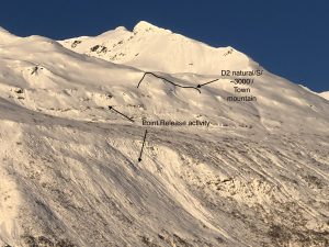
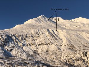
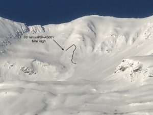
2/15- The sun came out in full force after 6 inches of new snow and produced a significant amount of point release wet/loose activity near the coast on solar aspects. 2- D2’s were also noted in the mid and high elevation band of town mountain and Mile high.
2/9- Several small (D1) natural avalanches were observed that failed on steep wind loaded terrain.
Weather
Check out our updated weather tab! A collection of local weather stations are available for viewing with graphs and tabular data included.
NWS Watches and warnings
NONE
NWS Point forecast for Thompson Pass
Date               Sunday 02/19/23         Monday 02/20/23
Time (LT)          06    12    18    00    06    12    18    00    06
Cloud Cover        SC    SC    SC    SC    FW    FW    FW    FW    CL
Cloud Cover (%)    45    30    30    25    15    10    10     5     5
Temperature        17    22    20    16    14    18    16    12    10
Max/Min Temp                   24          14          20           9
Wind Dir           NE    NE    NE    NE    NE    NE    NE    NE     N
Wind (mph)          6    11    16    17    18    24    27    26    13
Wind Gust (mph)    19    27    32    32    36    40    51    49    34
Precip Prob (%)    10     5     5     5     0     0     0     0     0
Precip Type
12 Hour QPF                  0.00        0.00        0.00        0.00
12 Hour Snow                  0.0         0.0         0.0         0.0
Snow Level (kft)  0.0   0.0   0.0   0.0   0.0   0.0   0.0   0.0   0.0
Click on link below for Thompson Pass weather history graph:

| Date:
02/19 |
24 hr snow | HN24W* | High temp | Low temp | 72 hour SWE* | February snowfall | Seasonal snowfall | Snowpack Depth |
| Valdez | ~6 | N/O | 32 | 22 | N/O | 63 | 208 | 64 |
| Thompson pass | N/O | N/O | 24 | 14 | N/O | 69 | 356 | 67 |
| 46 mile | N/O | N/O | 28 | 9 | N/O | ~16 | ~85** | 46 |
*HN24W- 24 hour Snow water equivalent in inches
*SWE– Snow water equivalent
**46 mile seasonal snowfall total begins December 1st.
Additional Information
Click on the link below for a running summary of the seasons weather history.
Announcements
The avalanche hazard is Considerable above 2000 feet for the intermountain and continental zones. Increasing north winds 2/19-2/20 will be forming fresh wind slabs that will be initially reactive in specific areas. Human triggered avalanches 1-2 feet in depth will be likely in areas where new wind slabs have formed. Natural avalanches are possible. In addition, point release avalanches will be likely on steep and rocky solar aspects.
Posted by Gareth Brown 02/19 8:00 am.
For a description of current avalanche problems, weather information, season history and more click the (+ full forecast) button. Avalanche forecasts will be issued Wednesday-Sunday.
If you have pictures of recent natural or human triggered avalanches or notice signs of instability such as shooting cracks or collapsing, leave an observation to help improve forecast accuracy.