Haines Avalanche Center
Above 2,500ftModerate
1,500 to 2,500ftModerate
Below 1,500ftLow
Degrees of Avalanche Danger
Avalanche Problems
Problem 1
The Bottom Line: This season has been a weather roller coaster. All the wild ups and downs in temperature have created a snowpack full of crusts and weak facets, with wind slabs on top. Currently, the risk of deep, deadly avalanches is very real, and you should exercise extra caution and keep a wide safety margin. Travel one at a time to minimize exposure to slopes 30 degrees and steeper. Stay clear of trigger points (thin areas, rocks, small trees) where you can easily trigger deep weak layers.
Thoughts on Risk Reduction: Let’s take a step back. We now have a few serious weak layers deep down in our snowpack that you do not want to trigger. These weak layers have *not* had time to heal. Your best bet to avoid a deadly avalanche is to reign in your expectations and lower your risk tolerance. Keep a wider-than-usual margin of safety by sticking to low-angle terrain, and giving dangerous areas a wide berth. There will be times later this spring when you can be more ambitious with the terrain… this is not the time.
Midpack Melt Layers and Crusts:
There is a serious weak layer about 60-70cm deep (The “Big Warmup” Layer, Formed Nov 17th). It is a thick refrozen crust with weak faceted snow above and below. This is an unusual and unpredictable weak layer, so a wide safety margin is necessary. Slides could break wider than expected, and could easily be triggered from shallow trigger points like rocks or small trees. You could ride the same slope numerous times until that right spot produces a big slide.
Observations from the Lutak Zone on 12/9 found moderate strength but easy propagation on failures within this layer. We know it to exist at all elevations above 1000ft — even up to the highest summits. We expect this layer (or other midpack crust-facet layers) to be an ongoing issue going forward.
Depth Hoar Formation (Above 3000ft in the Lutak zone):
October snow followed by long cold snaps created depth hoar at the ground in most areas. As the snow gets deeper, the load over this basal weak layer increases, along with unpredictability. This is becoming a high-consequence early-season snowpack that deserves respect and should drive conservative decision making.
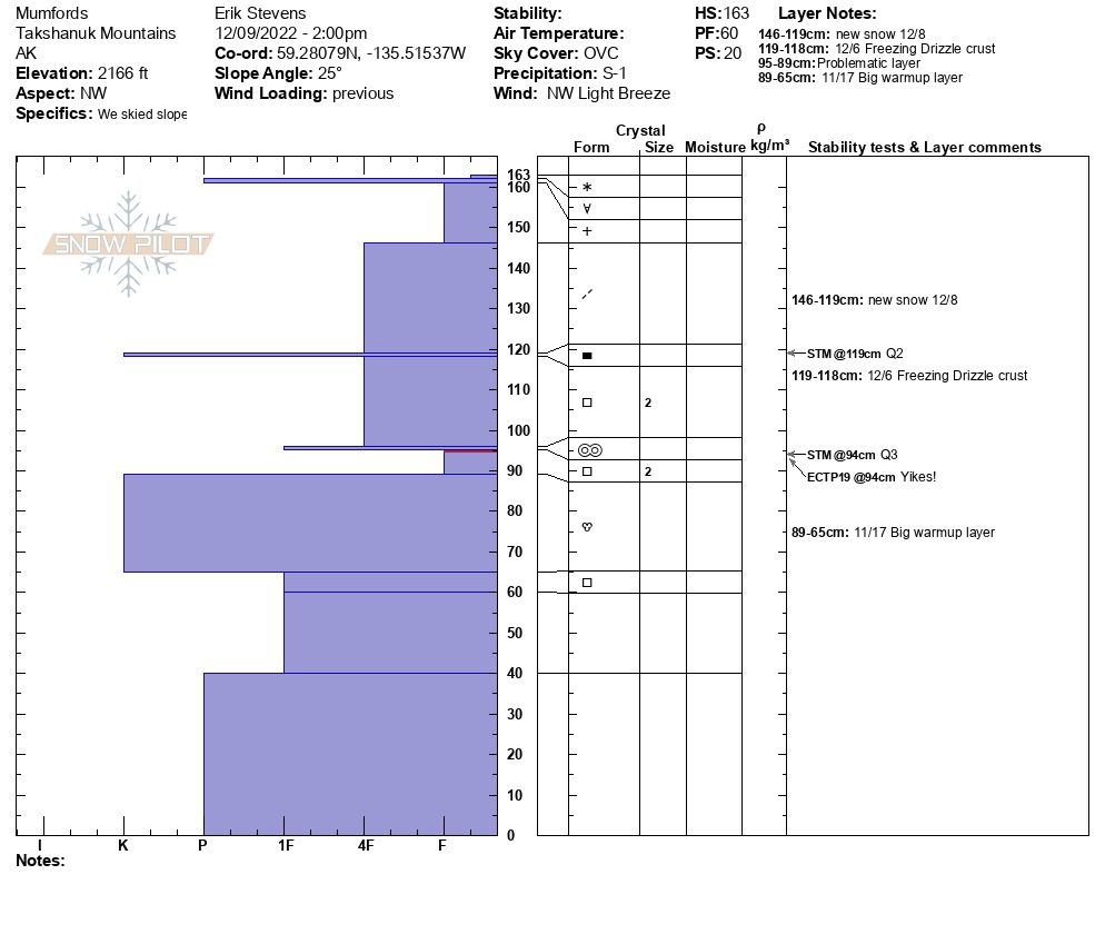
Snow profile from Lutak Zone 12/9
Snow pit photo from Lutak zone 12/1


Likelihood:
- Almost Certain
- Very Likely
- Likely
- Possible
- Unlikely
Size:
- Historic
- Very Large
- Large
- Small
Trend
- Increasing
- Steady
- Decreasing
Weather
Forecast:
Get ready for another arctic air outbreak. NW winds will start blowing hard Friday and bring temperatures crashing down below 0F in the alpine by Saturday. Skies should remain mostly clear into next week, with the cold temps and NW wind persisting.
Recent Weather Summary:
- Dec 15 brought warmth/light rain up to 2600ft.
- 4″ of snow fell Dec 12 in the Lutak zone, SE winds were quite strong
- There was a strong and cold NW wind event Dec 9 and 10
- A storm on Dec 7th brought 17″ of snow to the Lutak zone and 7-10″ to the Transitional/Pass zones
- Strong inversion on Dec 3 warmed higher elevations (38F Glacier Creek, 4800ft)
- An arctic outbreak brought very cold temperatures and strong NW winds Nov 27-Dec 2nd
- Complete Season Histories: Transitional Zone Lutak Zone
| Snow Depth [in] | Last 24-hr Snow/SWE [in] | Last 3-days Snow/SWE [in] | Today’s Freezing Level [ft] | Today’s Winds | Next 24-hr Snow/SWE | |
| Mount Ripinsky @ 2,500′ | 56″ | 0″ / 0.10″ | 4″ / 0.40″ | 0′ | strong, NW | 0″ / 0.00″* |
| Flower Mountain @ 2,500′ | 31″ | 0″ / 0.00″ | 0″ / 0.00″ | 0′ | strong, NW | 0″ / 0.00″* |
| Chilkat Pass @ 3,100ft | 9″ | 0″ / 0.00” | 4″ / 0.29″ | 0′ | strong, NW | 0″ / 0.00″* |
( *star means meteorological estimate )
Additional Information
It’s time to start thinking avalanche. Dust off your gear and make sure it is fully functional. Put new batteries in your beacons! Do a beacon practice to start the season and keep your skills fresh.
If you head into the hills, watch out for avalanche prone areas, and be especially careful of rocks and hidden hazards like crevasses beneath the snow. WEAR A HELMET!
Announcements
Forecasts for the 2022/2023 winter season will be Fridays-Sundays. Click the +Full Forecast link below for each zone to read more. Please submit your observations if you head out into the hills!