Valdez
Above 3,000ftModerate
1,500 to 3,000ftModerate
Below 1,500ftLow
Degrees of Avalanche Danger
Avalanche Problems
Problem 1
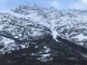
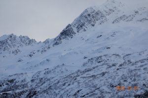
Strong north winds have been occurring since 11/26. Prior to the wind, around a foot of soft snow existed above the 11/13 rain crust. The strength of the latest wind event has stripped this soft snow away in most areas. A significant amount sublimation has occurred (the process of snow going from a solid directly to a gas state). In plain term, the snow blew away into space and deposition was limited in areas that received the strongest winds (Thompson Pass).
Wind slabs have since gained a lot of strength. on 11/30 wind slabs were found to be very hard (1 finger-pencil) and stubborn to unreactive up to 5000 feet. We can not yet rule out the possibility of a person or machine triggering a wind slab avalanche in a cross loaded gully, or the lee side of a high elevation ridge line (SE-NW). The most likely areas to encounter wind slabs that remain reactive will be in the Continental zone, where slabs overlay a faceted snowpack. In addition, protected areas where wind slabs are found to be softer (4 finger), slabs may still be reactive. Shooting cracks or collapsing are a sign that windslabs remain reactive. Further wind slab development should be limited as there is very little-no snow available for transport. The hazard for this avalanche problem is decreasing.

Likelihood:
- Almost Certain
- Very Likely
- Likely
- Possible
- Unlikely
Size:
- Historic
- Very Large
- Large
- Small
Trend
- Increasing
- Steady
- Decreasing
Problem 2
There are multiple rain crusts from October that are faceting in the mid and lower snowpack. Recent winds have created very strong snow at the surface making it difficult for a person or machine to affect these deeper layers.
At the present time this layer does not appear active, but if the weather remains cold and dry, these old rain crusts (bottom of the snowpack) will continue to weaken and could cause problems within our snowpack in the future.
There is a higher possibility of affecting these layers in the continental zone where a more faceted snowpack exists.

Likelihood:
- Almost Certain
- Very Likely
- Likely
- Possible
- Unlikely
Size:
- Historic
- Very Large
- Large
- Small
Trend
- Increasing
- Steady
- Decreasing
Avalanche Activity
11/14- Debris from a D3 natural avalanche at snow slide gulch ended 100 vertical feet above the Lowe river.
Large avalanches (D2-2.5)also occurred in multiple other locations including Berlin Wall, Catchers Mitt, South Three Pigs and Billy Mitchell. The activity extends beyond this list, and mostly occurred during the peak of warming and precipitation on 11/13.
Multiple natural D1-1.5 avalanches were observed on multiple aspects at low elevation. No step downs noted.
12/1- 2 D2.5 natural avalanches were noted on Three Pigs (Beaver slide, Pig Leg). Pig leg ran into the top 1/3 of the fan and Beaver Slide stopped near the end of its track. These both likely occurred during the outflow wind event 11/26-11/29.
D2 natural wind slab was observed on 40.5 mile peak on a west aspect ~3000′. Crown depth range estimated 1-2 feet and 200′ long
Weather
Check out our updated weather tab! A collection of local weather stations are available for viewing with graphs and tabular data included.
NWS Watches and warnings
None
NWS Point forecast for Thompson Pass
Date               Friday 12/02/22         Saturday 12/03/22
Time (LT)          06    12    18    00    06    12    18    00    06
Cloud Cover        FW    SC    SC    SC    SC    BK    OV    OV    SC
Cloud Cover (%)    20    45    50    50    35    55    80    75    50
Temperature         6    16    21    20    19    25    27    23    22
Max/Min Temp                   22          18          27          21
Wind Dir           NE    NE     N    NE     W    SW     W    SW    SW
Wind (mph)         16    11     4     3     4     4     3     3     3
Wind Gust (mph)    34    27    20    14
Precip Prob (%)     0     0     0     0     0     0     0     0     0
Precip Type
12 Hour QPF                  0.00        0.00        0.00        0.00
12 Hour Snow                  0.0         0.0         0.0         0.0
Snow Level (kft)  0.0   0.3   0.7   1.2   1.0   0.5   0.6   0.7   0.7
Click on link below for Thompson Pass weather history graph:

| Date:
12/2 |
24 hr snow | HN24W* | High temp | Low temp | 72 hour SWE* | December snowfall | Seasonal snowfall | Snowpack Depth |
| Valdez | 0 | 0 | 41 | 29 | 0 | 0 | 34 | 11 |
| Thonpson pass | 0 | 0 | 22 | 9 | .04 | 1 | 98 | 30 |
| 46 mile | 0 | 0 | 22 | -2 | Trace | 1 | 1** | 16 |
*HN24W- 24 hour Snow water equivalent in inches
*SWE– Snow water equivalent
**46 mile seasonal snowfall total begins December 1st.
Additional Information
Our snow season began with above average precipitation and temperatures. Beginning in September, snow lines generally hung around 4500′ until 10/12. At that point our area received the first snow down to sea level with 12-16 inches on the north side of Thompson Pass.
On 10/15 wet conditions continued with the freezing line rising to 5000′ or higher. As skies finally cleared on 10/22 we were left with a thin rain saturated snowpack capped by a stout rain crust up to 4500′. Above 4500′ much deeper snowpacks existed due to significant early season snowfall at upper elevations.
Dry and cold conditions along with moderate outflow winds finished out the month of October.
On 11/1 precipitation returned with 18 inches of snow and ~1″ of SWE on Thompson Pass. This new snow was initially reactive with several natural D2 avalanches reported on Thompson Pass. These slides were running on a firm bed surface consisting of old rain crusts and old wind slabs from October.
On 11/4 a strong north wind event kicked up with 65 mph+ winds on Thompson Pass. Our snowpack received significant damage as already thin snow below 4500′ was stripped down to old wind slabs, rain crusts and the ground.
Precipitation returned on 11/8 and became heavy on 11/11. Storm totals of around 50 inches were recorded at Thompson Pass DOT between 11/8-11/13. Snow lines rose to ~3000′ near the tail end of the storm with heavy rain occurring in low lying areas.
Skies cleared on 11/14 through 11/18 with a strong temperature inversion setting up. Valley temperatures north of Thompson Pass fell to 0° F with above freezing temperatures existing above 4000 feet. Valdez temps remained mild. This weather allowed for widespread surface hoar up to 1 cm to develop in low lying areas.
Precipitation returned on 11/19, with incremental snowfall on Thompson Pass and areas north. The Valdez area received rain during this period. 12 inches have been recorded at TP DOT between 11/9-11/23.
11/26-11/29- Strong outflow (N) wind event. Many areas below 3000′ were stripped to the 11/13 rain crust, destroying the 11/19 BSH layer.
Announcements
The avalanche hazard is Moderate above 1500 feet in The Maritime zone. Human triggered wind slab avalanches 1-2 feet deep remain a possibility in cross loaded gullies, as well as the lee side of terrain features and high elevation ridge lines. This avalanche problem is becoming less likely moving forward as wind slabs gain strength. The avalanche hazard is low below 1500 feet due to a very thin snowpack that has been rain saturated and is now refrozen.
Posted by Gareth Brown 12/2 8:00am.
For a description of avalanche problems, weather information, season history and more click the (+ full forecast) button. Avalanche forecasts will be issued Wednesday-Sunday.