Haines Avalanche Center
Above 2,500ftConsiderable
1,500 to 2,500ftModerate
Below 1,500ftModerate
Degrees of Avalanche Danger
Avalanche Problems
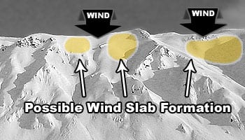
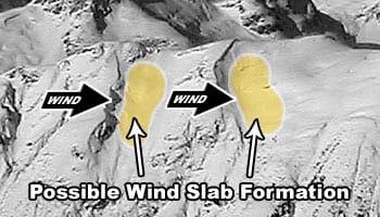
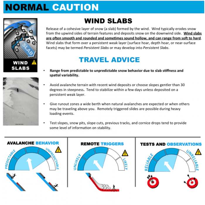
Problem 1
Confidence: High. Distribution: Specific to wind loaded aspects (E-N-W). Sensitivity: Reactive.
On Wednesday evening a strong SE wind event caused new wind slabs to build on lee aspects E-N-W above treeline. The drifted storm snow will be more likely to trigger from thin areas in the terrain, such as underlying rocks, cliffs, or vegetation. Keep in mind the possible loading and cross loading patterns, look/listen for slabby snow underfoot. If you venture into avalanche terrain, reduce your exposure by traveling one-at-a-time across suspect slopes, and be mindful of any terrain traps below you where all this new snow can pile up extremely deep.
Very sunny weather means strong solar radiation. Sun weakens snow, especially on un-supported slopes and around cornices (see cornice problem below).
The deep persistent problem has been taken off for now. These layers have not seen recent activity and are considered dormant.

Likelihood:
- Almost Certain
- Very Likely
- Likely
- Possible
- Unlikely
Size:
- Historic
- Very Large
- Large
- Small
Trend
- Increasing
- Steady
- Decreasing
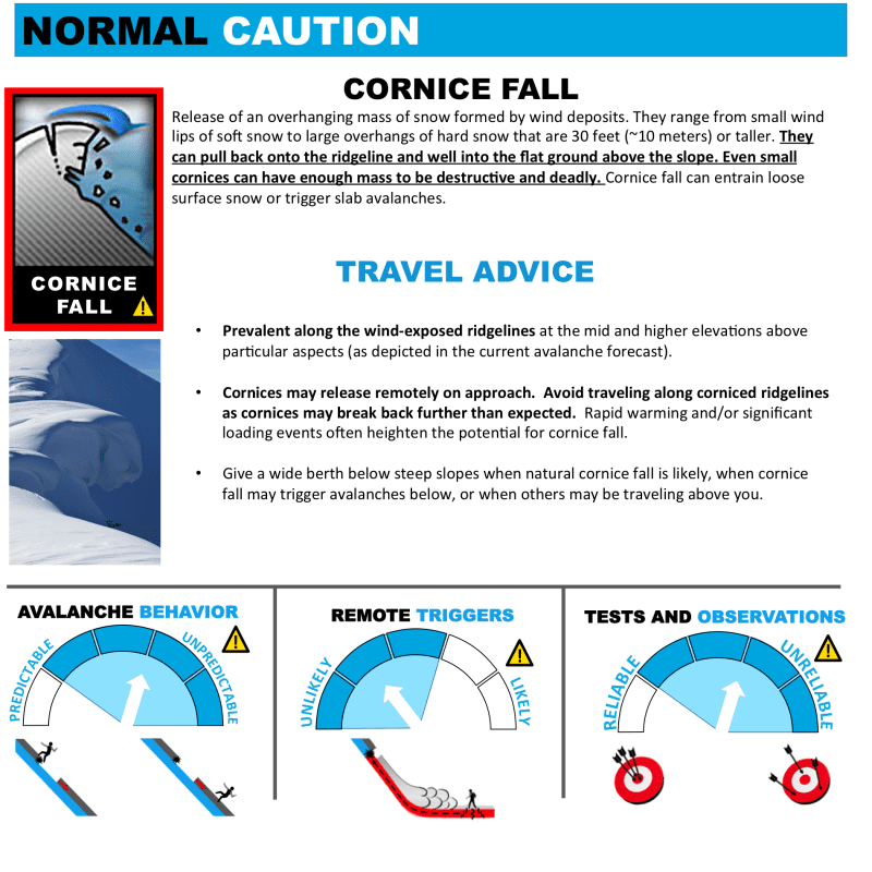
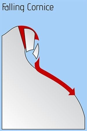
Problem 2
Confidence: High. Distribution: Specific to wind loaded aspects (E-N-W). Sensitivity: Reactive.
Recent SE winds have amplified cornices along ridges and on mountain tops. Solar radiation weakens cornices and increases the likelihood. Minimize your time spent under cornices and lookout for run-out with looming cornices above. On ridgelines they are difficult to judge from above and usually always break further back than expected. They are more reactive when the sun comes back in the spring.
Likelihood:
- Almost Certain
- Very Likely
- Likely
- Possible
- Unlikely
Size:
- Historic
- Very Large
- Large
- Small
Trend
- Increasing
- Steady
- Decreasing
Problem 3
Confidence: High. Distribution: Specific to solar aspects. Sensitivity: Reactive.
Last week’s daytime temperatures reached forty degrees at 2500′ Flower Mountain SNOTEL. Many southerly slopes at lower elevation have been active. Solar radiation and warm daytime temperatures will increase the likelihood of wet avalanches at lower elevations and around shallow terrain features.

Likelihood:
- Almost Certain
- Very Likely
- Likely
- Possible
- Unlikely
Size:
- Historic
- Very Large
- Large
- Small
Trend
- Increasing
- Steady
- Decreasing
Avalanche Activity
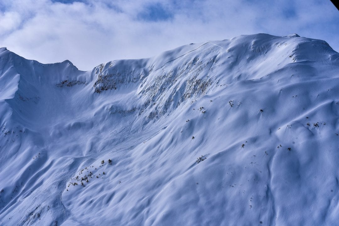
March 22nd – an impressive D3 natural slide in the Transitional Zone, on a steep unsupported S/SE aspect at about 4500ft. Occurred with direct solar radiation on the slope. This is an indication of the wide propagation potential and deep slab nature of our tricky persistent slab problem. South aspects should be considered highly suspect during times of solar radiation. Other aspects will likely also get into the action as temperatures warm up this spring.
Weather
A short lived but significant SE wind event Wednesday evening occurred after 16-24″ snow fell above 2,500′. Thursday into Friday high temperatures in the forties, with lows overnight in the twenties at sea-level. Northwest wind 10 – 15 mph. Increasing clouds through the weekend as more precipitation enters into the picture Sunday.
| Snow Depth [in] | Last 24-hr Snow/SWE [in] | Last 3-days Snow/SWE [in] | Today’s Freezing Level [ft] | Today’s Winds | Next 24-hr Snow/SWE | |
| Mount Ripinsky @ treeline | 130″+* | 0″ / 0.00* | 16″ / 0.80* | 0′ | mod, NW | 0″ /0.00* |
| Flower Mountain @ treeline | 110 | 0″ / 0.00 | 14″ / 0.60 | 0′ | mod, NW | 0″ /0.00* |
| Chilkat Pass @ 3,100ft | 61″ | 0″ / 0.00 | 4″ / 0.20 | 0′ | mod, NW | 0″ /0.00* |
( *star means meteorological estimate )
—The Mt. Ripinsky weather station is completely buried and no longer reporting.—
Additional Information
Practice like you play. Make sure all your rescue gear it is fully functional and your beacon has full batteries. Make sure 1) everyone in the group has a functioning beacon, shovel and probe 2) knows how to use them and 3) has trained in companion rescue in the last year. Keep your skills fresh. If you head into the hills, watch out for red flag avalanche conditions, natural avalanches, whoomphing or collapsing, and shooting cracks.
Education Video Links:
- AIARE
- How to Practice Avalanche Rescue Snowmobile Edition: https://youtu.be/2ML499MMDfM
- AK Sled Shed Motorized Learning:
- Intro: https://youtu.be/aoagKHfGkxs
- Personal Electronics in Avalanche Terrain: https://youtu.be/2Vz9S0OEyFk
- Snowmobile Macgyver Tool Kit: https://youtu.be/4WBNu_t6Bbk
- Head and Face Protection: https://youtu.be/jIzW89wOyZI
- Pre-season prep: https://youtu.be/zJmrb8cZlR4
- My Transceiver: https://youtu.be/yblaDWP7Jf8
- BCA Avalanche Safety for Snowmobilers
- How to Fix Common Snowmobile Problems in the Field: https://youtu.be/g9fiTxEvuFk
- Sleducation: Avalanche Safety for Snowmobilers: https://youtu.be/EWFOd_9DYb8
- Intro to Avalanche Transceivers for Snowmobilers: https://youtu.be/6ZLSBmsceog
- Avalanche Transceiver Trailhead Test for Snowmobilers: https://youtu.be/rWoXbadFBsY
- Avalanche Transceiver Searching Use Snowmobiles: https://youtu.be/w1ucyI6LMXM
- BCA Avalanche Rescue Series
- Beacon Search 101: https://youtu.be/nnHXLVA2FcE
- Avalanche Probing 101: https://youtu.be/-0_yDN5Drzw
- Avalanche Shoveling 101: https://youtu.be/dGQg9o3vAkM
- Organizing a Backcountry Rescue: https://youtu.be/gywtmukgt8s
- Post Avalanche Patient Care: https://youtu.be/9FyIeUy4wpQ
- Backcountry Evacuation: https://youtu.be/WPF-dciefL8
- Complex Multiple Burials Backup Techniques: https://youtu.be/pB6AfY2KyYo
- National Avalanche Center
- Avalanche Problems Explained: https://youtu.be/DkbnT_9-cHU
- Intro to North American Avalanche Danger Scale: https://youtu.be/r_-KpOu7tbA
Announcements
Click the + Full Forecast link below for each zone to read more. Keep an eye out for weather-related surprises this weekend. Anywhere with more new snow or wind than expected may have elevated danger.