Haines Avalanche Center
Above 2,500ftNone
1,500 to 2,500ftNone
Below 1,500ftNone
Degrees of Avalanche Danger
Avalanche Problems
Problem 1
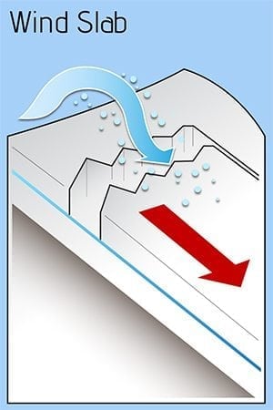
Northwest winds have been blowing pretty steadily in October, causing some fresh wind loading on Leeward aspects and building sporadic wind slab in our thin alpine snowpack. Normal caution is advised if you venture onto slopes 30 degrees and steeper. Avalanche season has begun in the higher elevations. Get out your avalanche eyeballs!
Likelihood:
- Almost Certain
- Very Likely
- Likely
- Possible
- Unlikely
Size:
- Historic
- Very Large
- Large
- Small
Trend
- Increasing
- Steady
- Decreasing
Weather
We have had a few good snowfalls above 4,000ft so far this autumn. Currently, snow depths range from a few inches at 3500ft, up to around 2ft above 4,500ft. We have had a long period of cold, clear, dry conditions that will likely begin the faceting process of any snow that does exist in higher elevations.
| Snow Depth [in] | Last 24-hr Snow/SWE [in] | Last 3-days Snow/SWE [in] | Today’s Freezing Level [ft] | Today’s Winds | Next 24-hr Snow/SWE | |
Mount Ripinsky @ treeline |
1″ | 0″ / 0.00* | 0″ / 0.00 * | 0 | Mod, NW | 0″ / 0.00 * |
Flower Mountain @ treeline |
1″ | 0″ / 0.00* | 0″ / 0.00* | 0 | Mod, NW | 0″ / 0.00 * |
Chilkat Pass @ 3,100ft |
1″ | 0″ / 0.00* | 0″ / 0.00* | 0 | Mod, NW | 0″ / 0.00 * |
( *star means meteorological estimate )
Additional Information
It’s time to start thinking avalanche. Dust off your gear and make sure it is fully functional. Put new batteries in your beacons! Do a beacon practice to start the season and keep your skills fresh. If you head into the hills, watch out for avalanche conditions, and be especially careful of rocks and hidden hazards like crevasses beneath the snow. WEAR A HELMET!

Announcements
We have begun periodic conditions updates for winter 2020/2021. Click the Full Forecast link below to read more.
