Hatcher Pass
Above 3,500ft Moderate
2,500 to 3,500ft Moderate
Below 2,500ftLow
Degrees of Avalanche Danger
Avalanche Activity
Yesterday a human triggered avalanche was triggered on the Truck Ramp, North side of Pinnacle Peak, in the Archangel Valley. This avalanche occurred on old, stiff, pillowed, wind deposited snow, sitting on facets over the (2/5) Chinese New Year’s Crust. It was very stubborn to trigger. Debris was shallow and not likely to bury a person, but the avalanche size was big enough to injure a person if they were caught and washed. One person was caught, but arrested within 15 feet. No injuries.
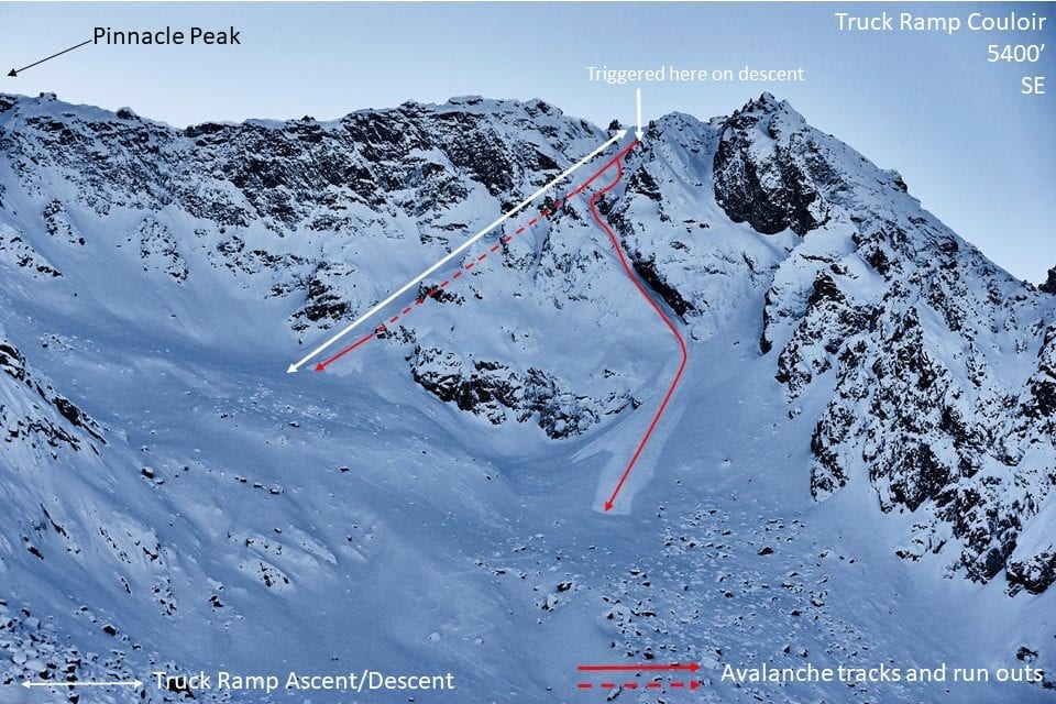
Truck Ramp, SE, 5300′, SS-ASc-D1.5-2-O, intentionally triggered at indicated trigger point in picture 40-50′ wide, 4-8″ deep, propagated around the corner and into the couloir on right, pulling out another starting zone and crown zippering down the sidewall of the couloir, 20′ wide, 2-8″ deep. Crown was continuous, one avalanche, two paths. Ran 800-900′ long.
Previous to yesterday’s human triggered avalanche, the last observed avalanche was on 2/6; click here for more information.
Weather
This week’s weather at 3550′:
Temps averaged 17ºF, with a low of 2ºF and a high of 32ºF.
2″ of new snow accumulated this week with 0.16″ SWE.
Overnight at 3550′:
Temps averaged 17°F.
No new snow.
This week’s weather at 4500′:
Temps averaged 13ºF, with a low of 1ºF and a high of 30ºF.
Winds averaged ESE 4 mph, max 13 mph . Gusts averaged 10 mph, max gust SSW 27 mph.
Overnight at 4500′:
Temps averaged 18ºF overnight, with a Low of 16ºF.
Winds averaged E 4 mph overnight. Max gust S 14 mph.
NWS Rec Forecast HERE
NWS point forecast HERE
State Parks Snow Report and Motorized Access information HERE
Additional Information
TREND – Rising avalanche hazard tonight through Monday.
A change in the weather pattern will begin today, with good chances for snow accumulation at HP through Monday. More chances for snow exist through the week with several low pressure weather systems in the line-up for south central AK.
2″ of new snow (0.14″ SWE) and light winds are forecasted today. This will not increase the avalanche hazard rating today. However, if the timing of the incoming storm is forecasted incorrectly and we get more than 6-8″ of snow today expect the avalanche hazard to rise abruptly.
NWS is forecasting 5-8″ of new snow tonight. This will begin to tip the balance and allow for some possible natural avalanche activity to begin.
Moving into Sunday a significant weather system could push snow totals from Saturday into Sunday evening close to the 20″ mark. Expect the avalanche hazard to rise to CONSIDERABLE at mid to upper elevations tomorrow, and MODERATE at low elevations. Weak layers in the snowpack have been re-activated by similar loading cycles this season, and tomorrow is no exception.
Monday is a bit far out for weather forecasting accuracy, with some model discrepancy, however, there is a chance for upper level SW flow, and another classic Hatcher Pass Dump. If this occurs more natural avalanche activity will be on tap.
This morning’s NWS point forecast for Hatcher Pass:
Announcements
BOTTOM LINE
A weather pattern change is expected today through Monday. Significant new snow is expected beginning tonight through Sunday which will increase the avalanche hazard to CONSIDERABLE tonight. Preliminary estimates could put snow totals from today through Sunday at 14-20″.
Today, a MODERATE avalanche hazard exists for stubborn to unreactive persistent slab avalanches at mid to upper elevations, on a variety of aspects, 0.5-3 feet deep, on slopes 35° and steeper, and may be large enough to bury, injure or kill. Human triggered avalanches are possible and natural avalanches are unlikely.
This kind of avalanche problem is difficult to assess and may behave unpredictably.
Today, a LOW hazard exists at low elevation.
For today, safer, good riding conditions can be found in wind protected areas at the lower elevations. Other areas include wind protected, low angle slopes, at the mid to upper elevations, out of the runnout of steeper slopes from above.
SUBMIT your OBSERVATIONS here!
Donte by clicking on the Blue Donate to support HPAC button to the right of the home page >